| N.C.
16 155 miles |
|
|
|
|
| The Road: |
|
Begins at NC 75 Waxhaw (Union County) and ends at the Virginia State Line above Grassy Creek (Ashe County). The route continues 307 more miles as VA 16 and WV 16 to WV 2 St. Mary's, WV.
|
Towns and Attractions: |
|
Union Co:Waxhaw
Mecklenburg Co:Charlotte
Gaston Co:None
Lincoln Co:None
Catawba Co:Newton, Conover
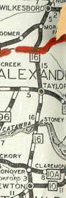
Alexander Co:Taylorsville
Wilkes Co:Moravian Falls, Wilkesboro
Ashe Co:Blue Ridge Pkwy, Jefferson
|
History: |
|
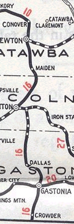
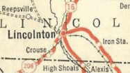
NC 16 is an original state highway that initially ran from NC 10 Conover south through Lincolnton, Dallas and Gastonia before reaching the South Carolina line. The route continued as SC 16 to Columbia, SC.
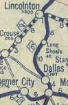
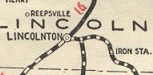
NC 16 between Lincolnton and Dallas may have originally used Southside Rd to Long Shoals then Long Shoals Rd and today's NC 279 to Dallas. The 1922 and 1923 Auto Trails Maps suggest this routing. Hoping to acquire a 1923 NC Official Map to confirm...the 1924 Official shows NC 16 heading east from Lincolnton east to Boger City, then used Salem Church road to head south to High Shoals, then using today's US 321 Business down to Dallas.
In 1926 NC 16 definitely was rerouted in the Lincolnton area. Instead of NC 16 heading east to Boger City, 16 continued south on Aspen St to South Lincolnton and on to High Shoals.
NC 16 original routing
|
NC 16 Dallas to Lincolnton?
NC 16 with NC 27 duplex
NC 16 more direct
|
In 1929, NC 16 was extended north to Taylorsville and Wilkesboro, replacing the original NC 67.
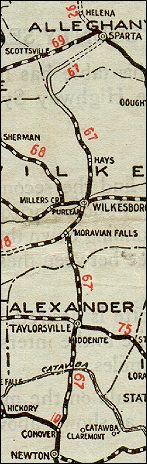
NC 67 Conover to Wilkesboro
|
NC 16 Conover to Wilkesboro
|
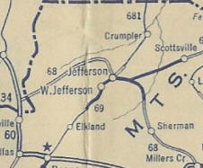
Also in 1929, NC 16 was further extended northwest to Jefferson and then west to the Tennessee State Line. This was a replacement for the first NC 68.
Original NC 68
|
NC 16 replaces NC 68
|
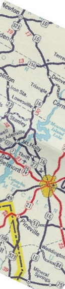
In 1930, US 321 was assigned to NC 16 from Conover to the South Carolina Line. Thus in 1934, NC 16 was truncated to US 64-70-321 (1st Ave at 1st St) Conover. Today, the original route followed by NC 16 is NC 16 from Conover to NC 10 Newton; S. Main St; US 321 Business through Maiden to Lincolnton, where NC 16 used Aspen St through the city; US 321 Business south to NC 275-279 Dallas; Gaston St and Marietta St south to Gastonia; US 321 to the state line.
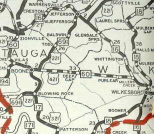
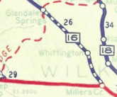
In 1937, NC 16 was rerouted northwest of Wilkesboro to its modern ascent of the Blue Ridge to Glendale Springs, leaving behind today's lengthy and gnarly "Old NC 16"
NC 16 original Blue Ridge ascent
|
NC 16 rebuilt to the west
|
About 1940, NC 16 was re-extended southeast from Conover: Duplex with US 321 to Newton; replaced NC 73 from Newton to Lincoln County; replaced NC 271 Lincoln County to Charlotte; replaced NC 262 Charlotte to Waxhaw.

Conover to Waxhaw using several routes
|
NC 16 Conover to Waxhaw
|
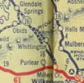
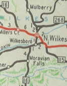
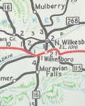
Wilkesboro area changes NC 16 initially followed Brooktown Rd into Moravian Falls, then along "old NC 18", then Fletcher St and Corporation St to S Cherry St. to Main St Wilkesboro; follows today's NC 268 to N. Wilkesboro; the D St west to SR 1500 then northwest to SR 1372 "Old US 421 Boone Trail" over to Millers Creek then up today's NC 16.
In 1954, NC 16 went northwest at NC 268 west of Wilkesboro and followed in today's SR 1185 Curtis Bridge Rd to SR 1372 "Old US 421". Much of the old route remained part of NC 18-268.
Between 1966-68, NC 16 was placed on US 421's routing west out of the area, then due north to Millers Creek like today. This left behind SR 1372.
In 1969, US 421 and NC 16 were placed on the new freeway. Also, NC 16 received its Moravian Falls Bypass.
NC 16 through all the towns
|
NC 16 bypasses N. Wilkesboro
|
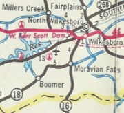
NC 16 bypasses Wilkesboro
|
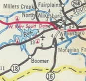
NC 16 bypasses Moravian Falls
|
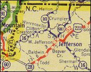
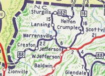
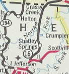
Ashe County changes: NC 16 underwent changes in Ashe County starting about 1940, when NC 16 was rerouted at Jefferson to continue north to the Virginia State Line at Grassy Creek. This was a replacement of NC 681. The old route west to Tennessee became an extended NC 88. Very briefly the Virginia side may have been VA 92, but officially VA 92 was renumbered as VA 16 in October 1940.
In two stages, NC 16 was totally rebuilt from Jefferson north to Virginia. First, in 1956 or 1957, NC 16 was routed north with US 221 away from Jefferson instead of into town, proceeding north to Shatley Springs where it met with old NC 16 (this is the overpass with ramps on NC 16). Then in 1958, NC 16 was placed on new alignment west of Crumpler all the way into Virginia (old 16 has its own state line crossing that meets up with VA 16 nearly a mile into the Old Dominion. The old route is Healing Springs Rd SR 1573 (SR 856 in Virginia).
NC 16 west of Jefferson
|
NC 16 north of Jefferson
|
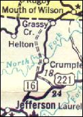
NC 16 avoiding Jefferson but not Crumpler
|
NC 16 avoiding Crumpler
|
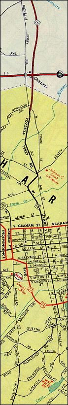
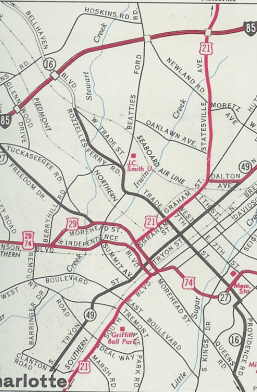
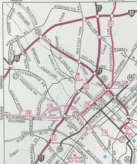
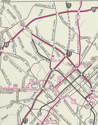
Charlotte changes: Initially, NC 16 ran through Charlotte (from South to North): Providence Road, as far north as Caswell Street, where today Providence changes its name to 3d Street; Caswell Road (now called Caswell Street) north for one block; Crescent Avenue (now called Randolph Road) north for a short distance; Hawthorne Avenue for a short distance; Elizabeth Street and Trade Street through the city center; and Rozzelles Ferry Road northwest to Gaston County. Parts of Rozzelles Ferry have since been renamed to Mount Holly Road and Valleydale Road. The 1959 General Drafting map shows this except also shows a change that occured about 1958 where it was put on new multilane alignment to meet the new I-85.
In South Charlotte, Providence Road originally did not continue north of Caswell Street into downtown -- there was no 3d Street there yet. This changed around 1963, when part of 3d Street was built as an extension of Providence. From the Providence/Caswell intersection, 16 was then run northwest over a short stretch of 3d, then northeast over Queens Road and Hawthorne Avenue before continuing into town on Elizabeth Street. This gave 16 one less zigzag on its way into town.
Even for a few years after the Northwest (now Brookshire) Freeway was built, 16 was signed all the way though downtown on Trade Street. This started to change in 1975, when 16 was taken off Rozzelles Ferry Road and routed from Trade along North Graham Street onto the freeway, continuing along Belhaven (now Brookshire) Boulevard north of where the freeway ended.
Between 1983-84, NC 16 was given its current routing through Downtown Charlotte.
Much of the Charlotte routing changes are from research done by Matt Steffora.
1. NC 16 through Charlotte 1959
|
2. NC 16 with one less zig-zag
4. NC 16 using some freeway
|
3. NC 16 still on Trade St all the way
5. NC 16 all freeway through downtown
|
Northwest of Charlotte, NC 16 has been undergoing a multilaning, a lot of which is totally new alignment. By 1990 this had reached Lucia (this resulted in a slightly expanded NC 273) and in 2007 was extended as new alignment to NC 73. NC 16 now has a temporary duplex with NC 73.
The 2007 Official implies the old 16 alignment is more NC 273.
The 2008 Rand McNally shows new NC 16 alignment complete past NC 150 an into Catawba County.
The 2007 Official also implies a Newton-Conover Bypass has been opened, but the online Catawba County map shows this as secondary right now and not NC 16 Bypass.
Adam Prince reports NC 16 may have recently been placed on the Newton-Conover Bypass, as the NC 16 exit on I-40 is closed and the exit signed as TO NC 16 is now just NC 16.
|
Comments: |
|
From Steffora: For a few blocks south of downtown Charlotte, N.C. 16 today runs over a pair of one-way streets: 4th Street northbound and 3d Street southbound. This creates a problem when trying to follow southbound 16 off the John Belk Freeway. The only exit is for 4th street, but 4th street runs the "wrong" way. So to follow 16, one must make a U-turn at the end the off-ramp (which itself makes a 180-degree turn), take a short connector between 4th and 3d, then turn left on 3d. Clearly the freeway was designed with little concern for 16.
NC 16 is a multistate route that almost makes 5 states. Waxhaw directly south to the state line was once part of NC 25 so it could've happened! In West Virginia, the route ends near a bridge to Ohio...
With the modernization of 16 everywhere, it is not much of a challenge to drive. Stick with it in Virginia and West Virginia and the story is much different!
The old NC 16 ascent up the Blue Ridge is still partially unpaved for your yesteryear driving pleasure.
In case you were wondering, the old Wilkesboro Rd north out of Taylorsville stopped being a state highway in 1926 when it was still NC 67.
|