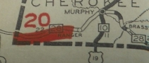
N.C. 28
< 27 | Home | 29 >
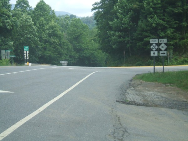
Photo: NC 28 at the NC 143 junction (Nicholas Mooneyhan)
| N.C. 28 83 miles | |||
| The Road: | Begins at US 129 Deals Gap very near the Tennessee Line (Swain County) and ends at the Georgia State Line below HIghlands (Macon County). The route continues 142 more miles as GA 28 and SC 28 two times each before ending at US 278/SC 125 in Beech Island, SC. | Towns and Attractions: | Swain Co.: Smoky Mtn National Park, Fontana Dam
Graham Co.: Fontana Village, Nantahala National Forest Swain Co.: Almond Macon Co.: Franklin, Cullasaja Gorge/Falls, Highlands |
History: |
Appeared in 1938 as the 3rd NC 28. It replaced NC 282 from the Georgia Line to Highlands, duplexed with US 64 to Franklin, and replaced NC 286 to Lauada (was called "Swain" on early maps), where NC 28 ended at US 19. Ironically, 282 and 286 were daughters of the original NC 28.
US 19 was relocated to avoid Almond about the same time NC 286 became NC 28. US 19 used to loop west and north to meet NC 286 about 1.5 miles north of Lauada, thus NC 28 might for the briefest of periods ended a little further north at first.
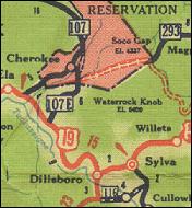
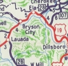
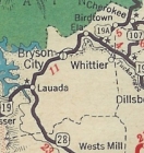
In 1939 or 1940, the Swain County portion of NC 28 below US 19-74 was completely reworked, a lot of it on new alignments. Surviving segments are Poppy Dr; bits of SR 1128 Sawmill Creek Rd/SR 1127 Davis Branch Rd; a bit of Old Brush Creek Rd; a bit of SR 1133 Brush Creek Rd In 1940, NC 28 was extended northeast with US 19 through Bryson City and Ela, then replaced part of NC 107 to end at the rerouted NC 107 (now US 441 Business) Cherokee. Between 1945-47, NC 28 was removed from Cook Rd in Highlands. In 1947, NC 28 was truncated back to US 19 Lauada. The piece from Ela to Cherokee became US 19 ALT (now it is just US 19).
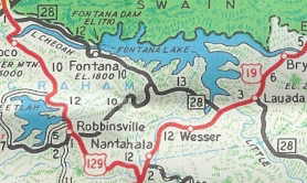
In 1954, NC 28 was extended south along US 19 to the Almond area, then split west as new primary routing along Old US 19 NB to Almond, then along the south side of Fontana Lake, then crossed over near Fontana Dam (but not on it). NC 28 then replaced NC 288 from here to US 129.
Sometime in the 1950s, NC 28 was rerouted to not pass under Bridal Veil Falls in the Cullasaja Gorge. About 1969 (bridge dates), NC 28 was rebuilt from Franklin to Gneiss. Surviving pieces are: SR 1571 Crane Cir in Franklin; SR 1669 Dutton Dr; a bit of SR 1668 Dutton Rd; Jake Rd/River Rd; SR 1564 Fuchs Dr; SR 1697 Old Highlands Rd; SR 1565 Dean Farm Cir; SR 1566 Lullwater Rd In May 1974 (NCDOT), NC 28 was given one-way splits in Franklin - NC 28 northbound continued to use Main St to Harrison Ave. NC 28 southbound used Main St west to Porter St, then south to Palmer St, then east on Palmer St with US 441 Bus NB back to Main St. Between 1992-94, US 19/74-NC 28 was removed from SR 1394 In 2005, NC 28 was improved from Stecoah to the Nantahala River. A few segments were new alignment. Surviving segments: unnamed loop bisected by Fontana Forest Rd; Laura Ln Between 2008-15, NC 28 was rerouted in Franklin to leave US 441 Business via Depot St, leaving behind Harrison Ave. As of 2025, Macon County maps do not show this change.
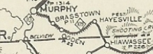
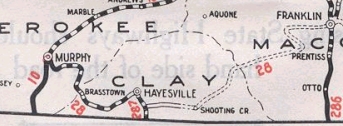
NC 28 Original Route In 1923, NC 28 west was rerouted west of Franklin to instead go to Rainbow Springs, Hayesville, and Brasstown to end at NC 10 (now US 19 Business) Murphy. The route from Franklin to Hayesville was new primary routing but Hayesville to Murphy was a renumbering of the original NC 109.The old route to Andrews is SR 1505/SR 1400 Junaluska Rd to Aquone, then SR 1310 Wayah Rd
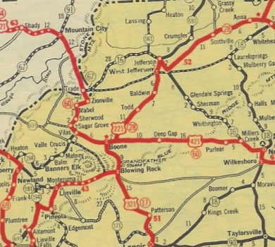
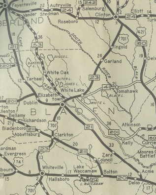
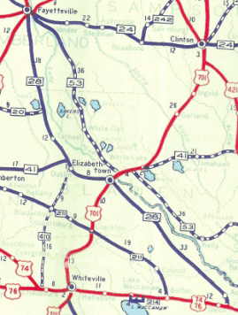
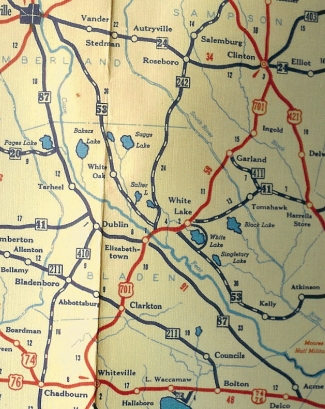
Surviving segments of the old route from Tennessee to Franklin that are not US 64 now: SR 1103 Simmonds Rd and SR 1137 Wolf Mtn Rd surrounding Wolf Creek; SR 1105 Allen Cir; SR 1111 Old State Rd near Johnsonville; SR 1133 Hopewell Rd at Hothouse; SR 1113 Holiness Church Rd at Sunny Point; Hardy Truett Rd/SR 1125 Clonts Rd loops; SR 1164 Rich Rd; Harris Chapel Rd; Hornet Ln; Bear Cub Ln; SR 1301 Wingate Rd; Die Bend Rd/NC 60 and SR 1676 Quarter Mile Rd in the Ranger area; Mauney Rd in Kinsey; SR 1304 Old Murphy Rd; SR 1398 Old Ranger Rd; US 19 Business into Murphy; leaving Murphy, NC 28 used Peachtree St, SR 1687 "US 64 ALT", a bit of NC 141, and SR 1685 Family Church Rd; SR 1548/1100 Old Hwy 64 through Brasstown, Ogden and Warne just north of the Georgia State line; US 64 Business into Hayesville NC 28 used Herbert St/Sanderson St/Anderson St/Myers Chapel Rd leaving Hayesville; SR 1146 Chatuge Dam Rd which ends at Chatuge Lake; abandoned; a bit of Hinson Center Rd; underwater; a bit of Patterson Rd/SR 1153 Elf School Rd; underwater to the NC 175 intersection with Old US 64; SR 1353 "Old Hwy 64 E"; SR 1349 "Old Hwy 64 E"; also National Forest Rd and Deep Gap Rd to Macon County. NC 28 used SR 1448 W. Old Murphy Rd/Charles Nolan Rd, plus SR 1451 Bill Dalrymple Rd; SR 1442 Patton Rd/Old Murphy Rd into Franklin. NC 28 likely used the W. Main St loop but it is unclear when that was bypassed; Palmer St Surviving segments of the old route from Franklin to Highlands that are not current NC 28 now: SR 1571 Crane Cir in Franklin; SR 1669 Dutton Dr; a bit of SR 1668 Dutton Rd; Jake Rd/River Rd; SR 1564 Fuchs Dr; SR 1697 Old Highlands Rd; SR 1565 Dean Farm Cir; SR 1566 Lullwater Rd; Surviving segments of the old route from Highlands to Bat Cave that are not US 64 now: under Bridal Veil Falls in the Cullasaja Gorge; Windy Hollow Rd and SR 1143 Frozen Creek Rd east of Quebec; SR 1320 "Old 64"/W. Loop Fork Rd near NC 215; US 178 and SR 1388 Old Rosman Hwy through Rosman...NC 28 may have used Main St initially but it is unclear when that was bypassed; SR 1392 Cherryfield Loop Rd/SR 1196 Avian Ct; SR 1393 Catheys Creek Church Rd; a bit of SR 1159 Old Country Home Rd; SR 1338 Selica Rd approaching Brevard. Leaving Brevard, NC 28 used SR 1504 Old Hendersonville Hwy/Vineyard Loop through Pisgah Forest and Penrose; SR 1203 Old US 64/McKinney Rd through Etowah to (no longer connects to) Cheerful Circle and SR 1324 Morgan Rd; part of Horseshoe Bend Rd/abandoned road along RR/Old Brevard Hwy/SR 1314 Banner Farm Rd to Horse Shoe. NC 28 probably used SR 1302 Pisgah Dr west of Hendersonville but it is unclear when that was bypassed; NC 28 used 6th/Church/7th through Hendersonville; SR 1898 Old Chimney Rock Rd at I-26 location Surviving segments of the old route from Bat Cave to Old Fort: NC 9 (except used SR 1608 Old Fort Loop Rd; SR 2804 Morgan Hill Rd; SR 2786 Lower Sand Branch Rd; SR 2797 Broad River VFW Rd/Rock Creek Rd); today's SR 2791/1103 Old Fort Rd to Old Fort The second NC 28 was immediately christened in the Great Renumbering. It was assigned to replace NC 21 from Fayetteville south to Elizabethtown and southeast to US 17 (now US 74-76) near Delco. Today this is approximated N to S by: Ramsey St; NC 24; Wilmington Hwy to below I-95; NC 87; NC 87 Bus; NC 87; Old Acme Rd
|
Comments: |
NC 28 is extremely mountainous for the most part and spends much time above 2000 feet. It is especially scenic from Highlands to Franklin through the Cullasaja Gorge. NC 28 (with US 64) used to run behind the falls until the 1950s. But the hairpin ride doesn't have to end at US 129. You can tackle the Tail of the Dragon as you follow US 129 north to Maryville. The northern GA 28 segment is extremely twisty and difficult to make any time at all. The main segment of SC 28 is a major corridor connecting Walhalla, Seneca, Clemson, Anderson, Abbeville and McCormick with Augusta, GA. The first several miles of NC 28 northwest of US 19-74 have been improved to multilane status with the intent of one day being part of a rerouted US 19-74 around the Nantahala Gorge. Most of NC 28 north of Lake Fontana follows the ancient decommissioned path of NC 288. Fontana Village is essentially a family-oriented resort area. NC 28 is the last state route to keep its number into Georgia, thanks to the ol' GA 60 SPUR designation. The area around Franklin is dotted with "mine-your-own" gem operations. |

Last Update: 7 November 2025
Previous: N.C. 27 |
Next: N.C. 29
Top | NCRoads.com
Home