N.C. 40
< 39 | 40-A | Home | 41 >
Photo: Both NC 40 #1 and NC 40 #3 used this bridge over Smith Creek near Wilmington (Adam Prince)

| N.C. 40 dead | ||||||||||||||||||
| Formerly: |
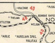
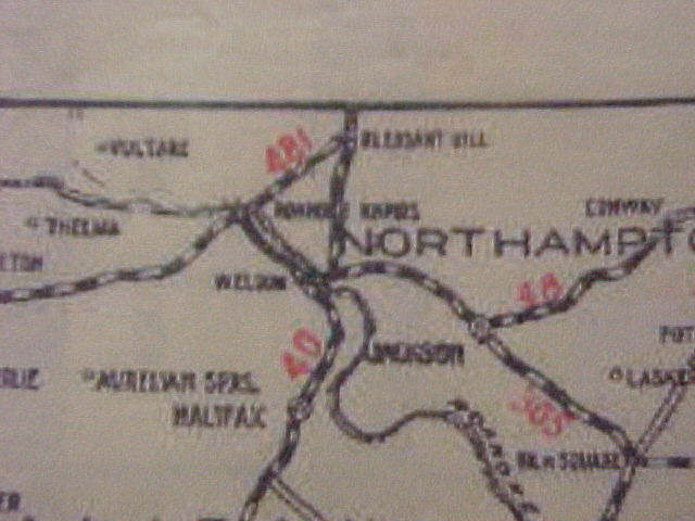
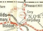
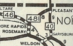
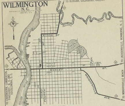
NC 40 #1: The first NC 40 was one of North Carolina's original main highways. In 1922, NC 40 began at original NC 20, on the corner of 4th and Market St in Wilmington. It proceeded to Nixon St, then east to today's McRae St. to leave the Wilmington area (none of these streets NC 40 used in Wilmington is primary highway now). NC 40 proceeded north on Castle Hayne Rd. At Castle Hayne NC 40 used Old Bridge Site Rd to cross the NE Cape Fear River. NC 40 followed US 117 and US 117 Business to Burgaw and to Burgaw and Wallace. It is ambiguous what NC 40 did next. The 1922 and 1923 Auto Trails Maps show NC 40 continuing along todays US 117 to Magnolia then using NC 903 over to Kenansville. The 1922 Pocket Map shows what the 1924 Official Map Shows (1921 and 1922 Officials are sufficiently vague here) NC 40 following today's NC 11 to Kenansville. Either way, NC 40 followed today's NC 24 Business west to Warsaw, then US 117 to Faison and Calypso. NC 40 picked us today's US 117-A into Mt. Olive. NC 40 may have used Center St and Old Mount Olive Hwy all the way to Goldsboro but if it did it stopped doing so (based on pavement) before 1924. NC 40 followed today's US 117 Bus through Goldsboro, then US 117 through Pikeville and Fremont. NC 40 picked up today's US 301 via Dorothy Ln and Lattice Rd SE (cutoff by US 264 freeway). NC 40 followed US 301, Forest Hills Loop, US 301 and Goldsboro St into Wilson, exiting via Herring St out to the current US 301/NC 42 jct. NC 40 then followed US 301 north, used Elm City Rd through Elm City, US 301 through Sharpsburg, then US 301 Business through Rocky Mount. NC 40 continued on US 301 through Whitakers and Enfield, then used US 301 Business through Halifax. Approaching Weldon, NC 40 veered off US 301 and instead used Washington Ave into Weldon. NC 40 then cut west on 3rd St, following today's US 158 west to NC 125, then NC 40 followed Weldon St to NC 48 in Roanoke Rapids. NC 40 followed today's NC 48 to Gaston (the bridge over the Roanoke River was slighlty east of the current crossing) then followed today's NC 46 through Vultare into Virginia at today's NC 46 crossing. Virginia did not have its side as a primary highway then. In 1925, NC 40 was rerouted at Weldon. Instead of heading west on 3rd St, NC 40 went east on 2nd St then north on Sycamore St to cross the Roanoke River. NC 40 then followed US 301 through Garysburg and Pleasant Hill into Virginia, which assigned VA 24 to its side. Previously, only Weldon to Garysburg had been a primary route (NC 48). The old NC 40 became an extended NC 48 from Weldon to Roanoke Rapids, part of NC 481 from Roanoke Rapids to Gaston, and unnumbered from Gaston northwest to Virginia (though eventually this became NC 46). It appears that in 1926, NC 40 was rerouted in the Weldon area back to its 1922 routing to Roanoke Rapids and Gaston, then went northeast to Pleasant Hill generally along today's NC 48 but may have used Brooks Rd right at US 301. This replaced the first NC 481, and the straight Weldon to Pleasant Hill road became the second NC 481. Additionally in 1927, US 17-1 was assigned to all of NC 40, except in the Weldon area (US 17-1 always followed today's US 301 routing). In 1930, NC 40 was rerouted in the Weldon area back to its 1925 Routing, replacing the second NC 481. NC 40's old routing became NC 40A. The NC 40 routing changes all sound too strange to be true, but reflect what the NC Officials of 1924-31 show. I noticed that VDOT official maps stopped labeling these roads on the NC side between 1929-33, probably because they couldn't keep up with the changes.
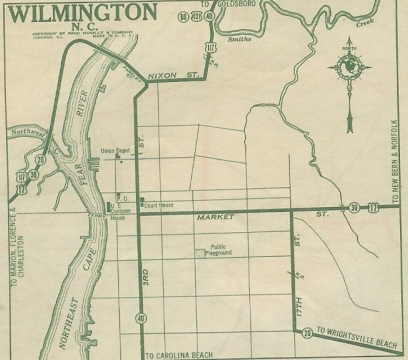
About 1929, NC 40 was extended south to Carolina Beach as new primary routing. Additionally, US 17-1 was renumbered as US 117 Wilmington to Wilson, and US 301 Wilson to Virginia. The 1930 New Hanover County Map shows NC 40 using 3rd St. instead of 4th Street in Wilmington, though that change could have occurred anytime between 1924-30.
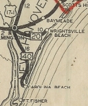
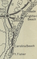
In 1932, NC 40 was extended as new routing south from Carolina Beach to Fort Fisher. The small stub of Atlanta Ave east of US 421 looks to have been the end of NC 40 from 1929-32.
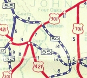
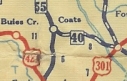
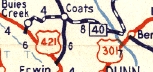
As you can imagine, the Great Renumbering was hard on NC 40. NC 40 was truncated to run only from Wilmington south to Fort Fisher, starting in late 1934, leaving behind US 117 and US 301. Alas, this short remaining NC 40 piece was renumbered as an extended US 421 in 1935. The second NC 40 was born about 1937. It began at NC 50 (using Lincoln St) Benson and used today's NC 27 into Harnett County. At the Black River, NC 40 used Delma Grimes Rd to Cane HIll Rd to Main St and ended at NC 55 Coats. This was a renumbering for part of today's NC 50. In 1940, NC 40 was extended west as new routing by duplexing with NC 55 north to modern NC 27, then west as new primary routing along NC 27. NC 40 used a smidge of Sheriff Johnson Rd to Old Stage Rd, then south on Old Stage Rd to Kivett Rd, then west to Main St in Buies Creek. NC 40 ended at US 421 which was using Leslie Campbell/Marshbanks at that time. Between 1947-49, NC 40 was placed on NC 27's modern routing everywhere. Also, NC 40 east was truncated slightly to the current NC 27-50 split in Benson. NC 40 was renumbered as an extended NC 27, as it remains today (except right in Buies Creek), in 1957.
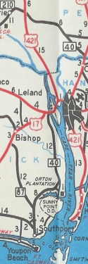
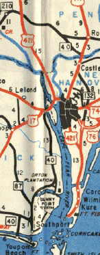
There was a third NC 40 for a brief time. In 1957, NC 40 was reborn in the Wilmington area. It ran from NC 87 Southport north to US 17-74-76 Belville, replacing part of NC 130. NC 40 was then multiplexed with US 17-74-76 north and east across the Cape Fear River into northern Wilmington, then followed US 117 to Castle Hayne, then veered west to end at NC 210 Bells Crossroads. The piece northwest of US 117 had been part of NC 210 briefly after being US 421 for years.
| |||||||||||||||||

Last Update: 21 June 2008
Previous: N.C. 39 |
Next: N.C. 40-A | N.C. 41
Top | NCRoads.com
Home