| N.C.
66 45 miles |
|
|
|
|
| The Road: |
|
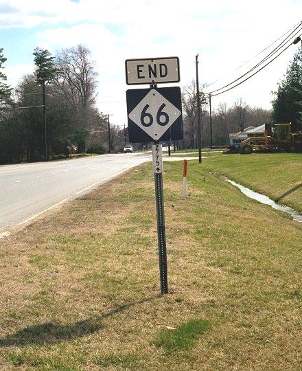
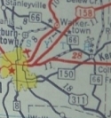
Begins at US 311 Horneytown (Forsyth County) and ends at NC 89 in northern Stokes County
|
Towns and Attractions: |
|
Forsyth Co.: Kernersville, Walkertown, Stanleyville, Rural Hall
Stokes Co.: Hanging Rock State Park
|
History: |
|
NC 66 was born in late 1934 as a renummbering of NC 661. Ran from US 52 (now "Old US 52") near Rural Hall north to NC 89.
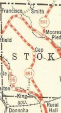
NC 661 Rural Hall to NC 89
|
NC 661 becomes NC 66
|
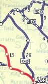
In 1936, NC 66 was extended southeast with US 52 through Rural Hall to Stanleyville, then southeast as new primary routing to US 421 (now Old Greensboro Rd) at Talleys Crossing.
Between 1947-49, NC 66 was rerouted to the south of central Walkertown, leaving behind today's Salem Rd and Main St.
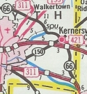
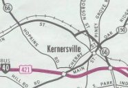
In 1955, NC 66 was extended south with US 421 to Kernersville, then south further as upgraded routing to end at US 311.
In 1983 or 1984, NC 66 south was truncated to the new US 311 freeway.
No later than 1993, NC 66 was rerouted around the north side of central Kernersville, leaving behind Mountain St.
NC 66 extended to US 421
|
NC 66 extended to US 311
|
NC 66 truncated to US 311 fwy
|
NC 66 rerouted around Kernersville
|
The first NC 66 was an original state highway that began at NC 60-65 (current 4th at Cherry) Winston-Salem. It followed today's Cherry St (parts of which have been usurped by University Pkwy), then Germanton Rd to today's US 52-NC 8, then went north on NE Patterson Ave, then north on University Pkwy to Stanleyville.
NC 66 then coincidentally followed today's NC 66 to Rural Hall, then picked up "Old US 52" to King, where old 66 used E. Dalton Rd and W. Dalton Rd out to Dalton. NC 66 then likely used Dalton Loop Rd and old US 52 to Pinnacle. 66 then followed VFW Rd, Old 52 Rd and Old Winston Rds from Pinnacle to Pilot Mtn. NC 66 used Main St through Pilot Mtn.
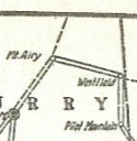
The 1921 Official map clearly shows NC 66 then heading due north on Old Westfield Rd and ending at NC 89 Westfield.
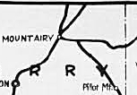
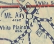
In 1922, NC 66 was rerouted at Pilot Mtn to head out Old US 52 and US 52 Business to Mt. Airy (except NC 66 used Main St all the way through downtown). NC 66 then followed Springs Rd and Gap Rd to the virginia State Line where Patrick and Carroll County Virginia meet. Both the 1922 Official and 1922 Rand McN Pocket Map show this.
In 1923, NC 66 was rerouted at Mt. Airy to turn left with current US 52 Business then use Old Fancy Gap Rd to the Virginia State Line where US 52 now crosses over, to meet the new VA 15. Springs Rd became secondary but later was part of NC 800/104 for a while.
NC 66 routed to Westfield
|
NC 66 rerouted to Mt Airy
|
NC 66 rerouted north of Mt Airy
|
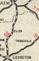
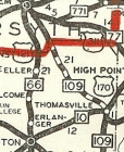
In 1925, NC 66 was rerouted south of Stanleyville to follow Patterson Ave into Winston-Salem. Then it replaced original NC 64 following Main St south to Waughtown St, then it used Old Lexington Rd to Davidson County where it becomes "Old NC 109". NC 66 followed this to Gum Tree, then used Gum Tree Rd over to "Old US 52". NC 66 followed Old US 52 through Midway and Welcome (used Old Winston Rd) before picking up NC 8 and going into Lexington where the route ended at NC 10 (now just Main St).
In late 1926, US 121 was assigned to the entirety of NC 66.
In 1928 or 1929, NC 66 was rerouted south of Winston-Salem to use today's Spur St south which becomes Old US 52. The old route to the east remained a piece of NC 77 and another part became a piece of NC 109 for a brief time.

Original NC 64 routing
|
NC 66 replaces NC 64
|
NC 66 straightened out south of W-S
|
In late 1934 both US 121 and NC 66 were renumbered as US 52.
|
Comments: |
|
Today's NC 66 looks extremely gnarly north of Rural Hall. The DeLorme Atlas implies it has never really been improved from its NC 661 days.
NC 66 does have a partial connector to the US 52 freeway near Rural Hall.
|