ROUTE LOG
SC 145: 0 - 0
SC 265: 6.8 - 6.8
SC 9 EB: 1.4 - 8.2
SC 9 WB, SC 268: 3.2 - 11.4
NC STATE LINE: 3.2 - 14.6
|
|
Creation: SC 109 appeared in 1934 or 1935 as new primary routing, running from SC 9 Mt Croghan to connect with NC 109. This is the only SC 109.
Adjustments: About 1938, SC 109 was removed from today's S-13-56 Hough Rd and placed on a more northerly route to North Carolina.

NC 109 initial N.C. entry
1936 Anson County NC
|

NC 109 shifted eastward
1938 Anson County NC
|
In 1939, SC 109 was extended east with SC 9 to Ruby, then south as new primary routing SC 85 (now SC 145).
In 1940 (bridge date) SC 109 was removed from S-13-57 and La Watson Rd.
In 1942, SC 109 was extended south as new primary routing to US 15 Hartsville, then a second discontinuous piece of SC 109 was added as new primary routing from SC 155 (now S-16-13) Auburn east to US 52 Floyd.
In 1947, SC 109 was reduced to its current routing leaving behind S-13-29, S-16-20, and S-16-24.
Improvements: SC 109's first pavement came in 1939 with its SC 9 multiplex.
In 1940, SC 109 was paved from NC south to SC 85.
No multilane segments
Comment: SC 109 serves local Chesterfield County traffic, while NC 109 has a long route through the Tar Heel State which once stretched to the Virginia State Line.
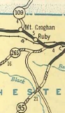
SC 109 out of Mt. Croghan
1937 Official
|
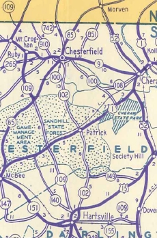
SC 109 extended to Hartsville and beyond
1942 Official
|
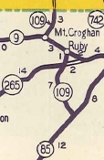
SC 109 truncated to SC 85
1948 Official
|
|