 |
From: North Carolina State Line (Cherokee County)
To: Kings Mountain National Battlefield Park (Chester County)
Total Length: 1.1 miles
The route continues 15 miles as NC 216 to end at NC 274 near Cherryville NC.
|
|
|
|
|
ROUTE LOG
NC STATE LINE: 0 - 0
END SC 216: 6.7 - 6.7
|
|
Creation: SC 216 appeared in 1960 as an upgrdade to S-11-45, running as it does today. This is the 2nd SC 216.
Adjustments: None
Improvements: SC 216 was fully paved upon creation; no multilane segments
Comment: SC 216 serves as the main way to reach the Kings Mountain National Battlefield. Note that NC 216 had ended at the South Carolina Line all the way back to 1930.
| 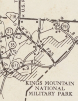
SC 216 at Kings Mtn NMP
1963 Cherokee County
|
| Previous SC 216's:
1946 ROUTE LOG
US 21: 0 - 0
END SC 216: 1.0 - 1.0
|
|
SC 216 #1: Appeared in 1939 as new primary routing running from US 21 south a mile through Sheldon.
In 1940, SC 216 was extended around in a loop back to US 21.
In 1942, the eastern half of SC 216 was downgraded to secondary status and is now S-7-47.
In 1947, the rest of SC 216 was downgraded to S-7-19.
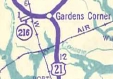
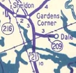
SC 216 appears in western Beaufort County
1939 Official
|
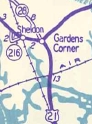
SC 216 loops back around to US 21
1940 Official
|
east half of SC 216 decommissioned
1942 Official
|
|