< 400 to 409 | Home | 430 to 439 >
|
|
|
| ROUTE LOG |
US 701: 0 - 0 SC 9 Bus EB, SC 917: 9.5 - 9.5 SC 9, SC 9 Bus END: 1.5 - 11 NC STATE LINE: 6 - 17
|
Creation: Appeared in 1949 as a renumbering of part of US 701. Ran as it does today. This is the 2nd SC 410.
| Adjustments: None Improvements: Fully paved at creation. No multilane sections. Comment: SC 410 was once part of original SC 40. The only place SC 410 really goes is Green Sea. | Previous SC 410's: |
SC 410 #1: Appeared in 1941 or 1942 as new primary routing. Ran from US 178-SC 2 Bowman north to SC 4 (current US 301), a total of 9 miles.
In 1948, SC 410 was downgraded to S-38-36. |
||||||||
| SC 411 not currently assigned | |||||||||||||||||
| Previous SC 411's: |
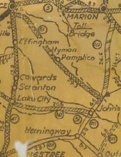
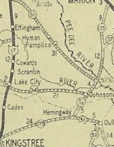
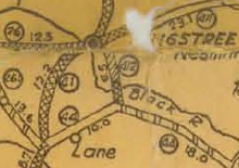
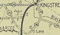
SC 411 #1: Appeared in 1924. Ran from SC 41 (current US 52 corridor, probably today's S-45-8) Kingstree east to Hemingway (replacing part of original SC 26's first routing), then north to end at SC 38 near Marion
In 1928, SC 411 was renumbered in its entirety to SC 175. Today this is SC 261 from Kingstree to Hemingway, SC 41 from Hemingway to near Centenary, and SC 41 ALT from SC 41 to US 501.
SC 411 #2: Appeared in 1941 or 1942 as new primary routing. Ran from SC 391 in eastern Saluda County northeast across SC 43 (current US 378) and ending at Lake Murray Shores, for a total of 5 miles. In 1948, SC 411 was downgraded to S-41-40. |
||||||||||||||||
|
|
|
| ROUTE LOG |
US 29: 0 - 0 SC 187: 1.4 - 1.4 SC 181: 5.5 - 6.9 SC 81: 0.3 - 7.2
|
Creation: Created in 1949 as new primary routing, running as it does today, except US 29 was 1/2 mile or so futher west than it is today. This is the 2nd SC 412.
| Adjustments: Between 1962-64, SC 412 was shortened by that 1/2 mile when Lake Hartwell appeared and US 29 was rerouted a little southward. Improvements: Paved since inception; no multilane segments Comment: SC 412 when combined with SC 187 makes a usable bypass of Anderson to Clemson when approaching from SC 81 NB. | Previous SC 412's: |
SC 412 #1: Appeared by 1926 as new primary routing. Ran from SC 41 (current SC 261) Kingstree south to SC 44 (current US 521).
In 1928, SC 412 was renumbered as part of SC 26. Today it is part of SC 377.
|
||||||||
|
|
|
| ROUTE LOG |
SC 81, SC 184: 0 - 0 SC 28: 6.3 - 6.3 SC 185: 3.4 - 9.7 SC 252: 5.9 - 15.6 US 76, US 178: 2 - 17.6
|
Creation: Appeared in 1949 as new primary routing. Ran as it does today.
| Adjustments: None Improvements: Fully paved upon creation; no multilane sections Comment: I have had no experiences with SC 413. | Previous SC 413's: |
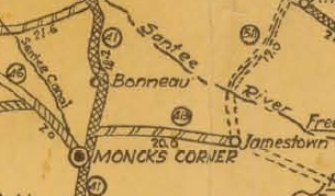
SC 413 #1: Appeared by 1926 as new primary routing. Ran from SC 41 (current US 17A-52 Business) Moncks Corner east to SC 511 (current US 17A-SC 41/45).
In 1928, SC 413 was renumbered as SC 178. Today all but the western 3 miles is US 17A. The rest is S-8-343, no crossing of the Tail Race Canal, S-8-342 and S-8-360.
|
||||||||
|
|
|
| ROUTE LOG |
US 276: 0 - 0 US 25 SB: 4.7 - 4.7 US 25 NB: 0.1 - 4.8 SC 253: 4.3 - 9.1 SC 101: 2.7 - 11.8 SC 14: 5.1 - 16.9
|
Creation: Appeared in 1949 as new primary routing. Ran as it does today. | Adjustments: None Improvements: Fully paved upon creation; multilaned only with its very brief US 25 multiplex, which was 4-laned between 1965-67. Comment: SC 414 serves Tigerville. | Previous SC 414's: |
SC 414 #1: Appeared in 1923 as new primary routing. Ran from SC 41 (current US 52 Business) Darlington southwest to SC 341 Elliott.
By 1926, SC 414 was extended southwest to SC 3 (current US 76 Business) Sumter. In 1928, SC 414 was renumbered as SC 763. Today it is US 401.
|
||||||||

| SC 415 not currently assigned | |||||||||||||||
| Previous SC 415's: |
SC 415: Appeared in 1949 as new primary routing. Ran from US 25 near its SC 414 jct southeast to SC 101 Greer, a distance of 12 miles.
Between 1962-64, SC 415 was renumbered as an extended SC 290. |
||||||||||||||
| SC 416 not currently assigned | |||||||||||||||
| Previous SC 416's: |
SC 416: Appeared in 1949 as new routing. Ran from SC 183 (current SC 8) Pickens east to US 25-276 (jct of Buncombe Ave and Rutherford St) in Greenville.
In 1956, SC 416 was renumbered as part of SC 183. |
||||||||||||||
|
|
|
| ROUTE LOG |
US 276: 0 - 0 I-385 (exit 31): 1.6 - 1.6 SC 14 NB: 0.9 - 2.5 SC 14 SB: 1.5 - 4 SC 146 WB: 6.2 - 10.2 Spartanburg-Greenville Line: 1 - 11.2 SC 146 EB: 0.4 - 11.6 SC 101: 1.7 - 13.3 SC 296: 8.4 - 21.7
|
Creation: Appeared in 1949 as new primary routing. Originally ran from US 276 (current SC 14) Simpsonville to SC 296.
| Adjustments: SC 417 was extended west to its current end between 1959-61, replacing a piece of US 276 which had been put on the newly completed freeway (now I-385). Improvements: Fully paved upon creation; no multilane segments. Comment: I used to used SC 417 (with SC 86 and SC 88, among other routes) as a backroad alternative to get to Spartanburg from Clemson. SC 417 is pretty quiet east of Simpsonville. |
||||||||
|
|
|
| ROUTE LOG |
US 25, SC 8: 0 - 0 I-385 (exit 23): 11.6 - 11.6 SC 14 SB: 0.8 - 12.4 SC 14 NB: 0.3 - 12.7 Laurens-Greenville Line: 0.9 - 13.6 Spartanburg-Laurens Line: 7.7 - 21.3 SC 101, SC 146: 3.9 - 25.2
|
Creation: Appeared in 1949 as new primary routing. Originally ran from US 25, 3 miles south of Ware Place northeast to Fork Shoals, Fountain Inn and over to Woodruff. The original length was 26 miles.
| Adjustments: In 1951 or 1952, SC 418's west end was moved 1.5 miles north, still to US 25, and still not in Ware Place. The old end route became part of S-23-50. Between 1962-64, SC 418 was put on mostly new construction from US 25-SC 8 to nearly Fountain Inn. The old route through Fork Shoals became S-23-154. In 1988, SC 418 was rerouted west of Fountain Inn to cross I-385 at Exit 23 instead of Exit 24. This routing replaced S-23-240. The old way presumably is more of S-23-154. Improvements: Fully paved upon creation; no multilane segments. Comment: I used to use SC 418 (with SC 8 and SC 88) as my main way to get from Charleston to Clemson. SC 418 east of Fountain Inn is convoluted with several turns required to get to Woodruff. |
||||||||
|
|
|
| ROUTE LOG |
SC 267: 0 - 0 US 601: 5 - 5 END SC 419: 2 - 7
|
Creation: Appeared in 1951 or 1952 running the way it does now, which was a renumbering of SC 267, which had been routed this way (and through Ft. Motte back around to US 601). This is the 2nd SC 419.
| Adjustments: None Improvements: Fully paved upon creation; no multilane segments. Comment: SC 419 is a rare case of a SC Primary route that ends abruptly without a body of water being the cause. | Previous SC 419's: |
SC 419 #1: Appeared in 1950 as new primary routing. Ran from SC 267 (current SC 419) near Ft. Motte east to US 601, a total of 1.6 miles.
In 1951 or 1952, SC 419 was downgraded to S-9-80. |
||||||
|
|
|
| ROUTE LOG |
US 178: 0 - 0 US 25 Bus: 5 - 5
|
Creation: Appeared in 1951 or 1952 as a renumbering of the northern discontinuous piece of SC 39. SC 420 ran the way it does now.
| Adjustments: None Improvements: Fully paved upon creation; no multilane segments. Comment: I have never driven SC 420, so I have nothing to offer here... |
|||||
|
|
|
| ROUTE LOG |
US 1, US 78, US 278, SC 125: 0 - 0 SC 126: 2 - 2 SC 191: 7 - 9 SC 118: 2 - 11 US 1, US 78: 0.5 - 11.5
|
Creation: Appeared in 1951 or 1952 as a renumbering of part of US 1-78, which was moved to its new 4-lane routing. Ran as it does today.
| Adjustments: None Improvements: Fully paved upon creation; no multilane segments. Comment: SC 421 serves the towns of Bath, Langley, Gloverville, and Warrenville. |
|||||
Last Update: 11 May 2005
Previous: SC 400 - 409 |
Next: SC 430 - 439
Top | South Carolina Hwy Index
Home