Previous SC 612's:
1946 ROUTE LOG
SC 64: 0 - 0
SC 64 WB: 3.9 - 3.9
SC 6 EB, SC 64 EB: 0.1 - 4.0
SC 6 WB: 0.2 - 4.2
END SC 612: 2.5 - 6.7
GAP IN ROUTE
BEGIN SC 612: 0 - 6.7
US 52: 1.7 - 8.4
|
|
SC 612: Appeared in 1940 as new primary routing. Ran from SC 6 Moncks Corner to Lions Beach and from US 52 Santee Circle west 1.7 miles. A projected road was shown to connect the two pieces that never existed due to Lake Moultrie.
In 1942, SC 612 was extended east with SC 6 and southwest on SC 64 (now US 17 ALT) before looping back around to SC 64 as new primary routing near the Berkeley County Airport.
In 1946, SC 612 was downgraded to S-8-34 Old Whitesville Rd/Bonnoitt St, S-8-21 Broughton Rd/Water Plant Rd, and S-8-20 Power House Rd.
Neither end of the missing section of SC 612 is publicly accessible although it is not underwater.
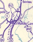
SC 612 appears at Moncks Corner
1940 Official
|
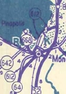
SC 612 extended south
1942 Official
|
|