< 700 to 709 | Home | 720 to 759 >
| SC 711 not currently assigned | |||
| Previous SC 711's: |
SC 711: Appeared in 1939 as new primary routing. It ran from US 17 over to Pawleys Island, a distance of 2 miles.
SC 711 was downgraded to S-22-10 in 1948. | 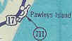 |
|
| SC 712 not currently assigned | |||
| Previous SC 712's: |
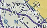
SC 712: Appeared in 1940 as new primary routing. Ran from SC 9 Riverdale east to SC 913 (current S-17-22).
In 1941 or 1942, SC 712 was extended east to SC 41 Lake View, for a maximum length of 12 miles. In 1948, SC 712 was downgraded to S-17-30. | 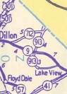
 |
|
| SC 713 not currently assigned | |||
| Previous SC 713's: |
SC 713: Appeared in 1941 or 1942 as new routing. Ran from SC 64 near Olar north to SC 70 Hilda, a distance of 8 miles.
In 1948, SC 713 was downgraded to S-5-27 and S-6-37. | 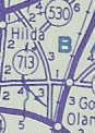 |
|
| SC 714 not currently assigned | |||
| Previous SC 714's: |
SC 714: Appeared in 1941 or 1942 as new routing. Ran from SC 70 Barnwell east to SC 304 (current S-6-14) south of Hilda.
The 5 miles of SC 714 were downgraded to S-6-29 in 1948. |  |
|
| SC 715 not currently assigned | |||
| Previous SC 715's: |
SC 715: Appeared in 1941 or 1942 as new primary routing. Was a 1 mile cutoff between SC 70 and SC 304 in Hilda.
In 1948, SC 715 was downgraded to S-6-xx Delk Ave. | |
|
| SC 716 not currently assigned | |||
| Previous SC 716's: |
SC 716: Appeared in 1941 or 1942 as new primary routing. Ran from US 17-701 Maryville south past Belle Isle Gardens to Cat Island, a distance of 9 miles.
In 1948, SC 716 was downgraded to S-22-18. | 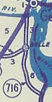 |
|
Last Update: 5 January 2005
Previous: SC 700 - 709 |
Next: SC 720 - 759
Top | South Carolina Hwy Index
Home