ROUTE LOG
SC 48: 0 - 0
US 76, US 378: 9.7 - 9.7
|
|
Creation: SC 769 appeared in 1942 with the same endpoints as today. This is the only SC 769.
Adjustments: n the mid-1940s, SC 769 was rerouted around Congaree National Guard Air Base.
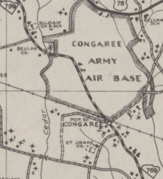
SC 769 through the Air Base
1942 Richland County
|
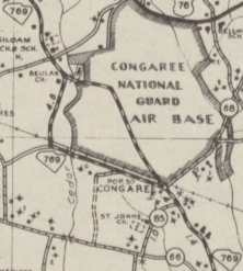
SC 769 around the Air Base
1948 Richland County
|
In 1947, SC 769 was downgraded to S-40-30.
In 1949, SC 769 was resurrected to its current routing. The 1948 Richland County map shows this already back in place.

SC 769 in eastern Richland County
1942 Official
|

SC 773 decommissioned
1947 Official
|

SC 769 returns
1949 Official
|
Improvements: Paved upon designation; no multilane segments.
Comment: SC 769 is a rare instance of a paved primary route being downgraded in the 1947 denumbering.
|