< 900 to 909 | Home | 920 to 929 >
| SC 910 not currently assigned | |||||||||||||
| Previous SC 910's: |
SC 910: Appeared in 1940 as new primary routing. Ran from SC 109 to SC 9 a little west of Chesterfield.
In 1941 or 1942, SC 910 was extended in both directions: east along SC 9 for a mile, then northwest towards North Carolina, ending about at S-13-47; SC 910 was also extended southwest from SC 109 over new routing through Angelus and ended at SC 151 near its jct with SC 903. These extensions brought SC 910's length to 23 miles. In 1948, SC 910 was downgraded to S-13-33 and S-13-34. | 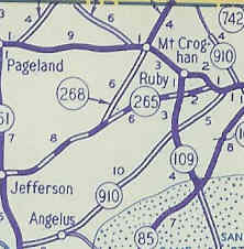 |
|||||||||||
| SC 911 not currently assigned | |||||||||||||
| Previous SC 911's: | SC 911: Appeared in 1940 as new primary routing, as a 1 mile stub south off of SC 9 east of Hickson. In 1948, SC 911 was downgraded to S-34-55. | 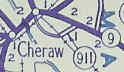 |
|||||||||||
|
|
|
| ROUTE LOG |
US 15, US 401: 0 - 0 SC 9: 8.5 - 8.5
|
Creation: Opened as a resurrected state route in 1951 or 1952, running as it does today. | Adjustments: SC 912 began in 1940 and originally ran from SC 9 west of Bennettsville north to SC 383 (current SC 79). In 1941 or 1942, SC 912 was extended east on SC 9 for a mile, then southwest to Madeline, then south to US 15-15A. SC 912 was 12 miles long at this point. In 1948, SC 912 north of SC 9 became S-34-55. The piece from Madeline east to SC 9 near Bennettsville became S-34-33. The piece from Madeline south to US 15 was downgraded too, but is today part of SC 912 once again. Improvements: Fully paved when resurrected Comment: A cutoff west of Bennettsville, but not really a traffic movement people need to make. 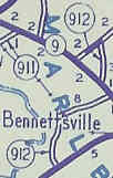 |
||||||
| SC 913 not currently assigned | |||||||||||||
| Previous SC 913's: |
SC 913: Appeared in 1940 as new routing. Began at today's S-17-34 in Dillon County, proceeding north across SC 9 Olivers Crossroads, and ending at the North Carolina State Line (continued as Ward Store Rd).
In 1941 or 1942, SC 913 was extended on its southern end to continue east to SC 41 below Kemper, maxing SC 913's distance out at 12 miles. In 1948, SC 913 was downgraded to S-17-22 and part of S-17-34. | 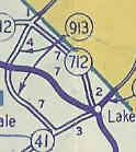 |
|||||||||||
|
|
|
| ROUTE LOG |
SC 200: 0 - 0 SC 9 Bus: 1.7 - 1.7
|
Creation: Opened as new state route in 1940. Originally ran from SC 9 southeast across SC 93 (today's SC 200) and ended at SC 529 (current S-29-19) Flemings Crossroads.
| Adjustments: In 1941 or 1942, SC 914 east was extended to US 521 at Elgin. In 1954 or 1955, SC 914 east was truncated to its current routing, leaving behind S-29-25 and S-29-38. Improvements: SC 914 was paved from SC 9 to SC 529 in 1942 and by 1948 was shown to be all paved. Oddly, the 1953 Official Map shows part of SC 914 to be not paved. Comment: Forms a southwest bypass of central Lancaster. Shown but not labeled on most official maps in the last 40+ years. 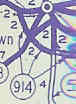 |
||||||
| SC 915 not currently assigned | |||||||||||||
| Previous SC 915's: |
SC 915: Appeared in 1940 as new routing, running a bowed 10 mile path between SC 9 on both ends bypassing Clio in the middle.
In 1948, SC 915 was downgraded to S-34-23 and S-17-21. | 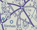 |
|||||||||||
| SC 916 not currently assigned | |||||||||||||
| Previous SC 916's: |
SC 916: Appeared in 1940 as new routing, running as a 3 mile spur west off SC 9 just outside Little Rock.
In 1941 or 1942, SC 916 was extended northwest to end at SC 831 (current S-34-19), bring SC 916's length to 7 miles. Additionally, a discontinuous second piece of SC 916 appeared, running from SC 381 near McColl east 4 miles to SC 83. In 1948, SC 916's original piece was downgraded to S-17-24 and S-34-40. The McColl piece became S-34-27. | 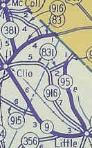 |
|||||||||||
|
|
|
| ROUTE LOG |
SC 38: 0 - 0 US 301, US 501: 5.7 - 5.7 SC 41 ALT: 9.3 - 15 Marion-Dillon Line: 0 - 15 SC 41 NB: 2.2 - 17.2 US 76 WB, SC 41 SB: 3.9 - 21.1 US 76 EB: 0.1 - 21.2 Horry-Marion Line: 4.6 - 25.8 SC 9 Bus, SC 410: 14.5 - 40.3
|
Creation: Appeared in 1940 as new primary routing. Originally ran from US 76 Mullins south to US 501 (current SC 319) Cool Springs.
| Adjustments: In 1948, SC 917 was rerouted to run from Mullins to US 701/SC 9 (now SC 410/9 Bus) as it does today. The piece running south to Cool Springs became part of S-26-23. The new route had been partly SC 804. In 1951 or 1952, SC 917 was extended west through Latta to SC 38 as it runs today, by multiplexing with SC 41; replacing SC 573 from SC 41 to Latta, and replacing a rerouted SC 38 from Latta westward. About 1968, SC 917 west was extended to I-95. About 2000, SC 917 west was truncated back to where it first ran into SC 38. Improvements: SC 917 became fully paved in 1949. There are no substantive multilane segments to SC 917. Comment: SC 917 is the highest number to survive the 1948 de-numbering, and remains the highest number in use today. 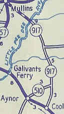 |
||||||
| SC 918 not currently assigned | |||
| Previous SC 918's: |
SC 918: Appeared in 1940 as new routing, running from SC 9 (at current SC 9-9 Bus split west of Lancaster) north to about Caskey.
In 1941 or 1942, SC 918 was extended north to SC 504 (current SC 5-75 jct) near Van Wyck for a total of 10 miles. In 1948, SC 918 was downgraded to S-29-29. | 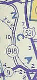 |
|
| SC 919 not currently assigned | |||
| Previous SC 919's: |
SC 919: Appeared in 1940 as new primary routing. Ran from SC 9 Clio northwest past Tatum and ending at SC 384 (current S-34-17) northeast of Breeden, a total of 8 miles.
In 1948, SC 919 was downgraded to S-34-22. | 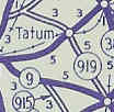 |
|
Last Update: 11 December 2004
Previous: SC 900 - 909 |
Next: SC 920 - 929
Top | South Carolina Hwy Index
Home