< 920 to 929 | Home | 1 to 9 >
| SC 930 not currently assigned | |||
| Previous SC 930's: | SC 930: Appeared in 1940, as a cutoff between SC 97 and SC 93 (current SC 200) east of Great Falls. In 1941 or 1942, SC 930 was extended 3 miles south of SC 97 to the Catawba River. In 1948, all 6 miles of SC 930 was downgraded to S-29-20. | 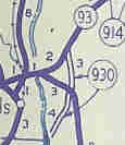 |
|
| SC 941 not currently assigned | |||
| Previous SC 941's: |
SC 941: Appeared in 1940 as a new primary route, running as a short spur south off of SC 94 (current S-14-37) in the Pudding Swamp. In 1941 or 1942, SC 941 became a 3-piece discontinuous route. The original piece was the middle piece. The northern piece ran from SC 54 (current US 378) south 4 miles to the north side of Pudding Swamp (ending at today's S-14-34). The southern piece ran from the US 301-521 split north of Manning east to SC 527.
It is unclear if these sections were connected before SC 941 was downgraded in 1948. The northern piece became S-14-35, the center original piece became S-14-19, and the southern piece became S-14-40. The 3 pieces in 1942 constituted 17 miles total. SC 941 was briefly the highest number in South Carolina. | 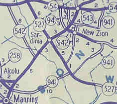 |
|
| SC 942 not currently assigned | |||
| Previous SC 942's: | SC 942: Appeared in 1941 or 1942 as new primary routing. Ran from SC 543 (current S-14-37) south through New Zion (crossing its parent SC 94) and ending 2 miles further south near current S-14-122, for a grand total of 3 miles. In 1948, SC 942 was downgraded to S-14-36. | |
|
| SC 943 not currently assigned | |||
| Previous SC 943's: | SC 943: Appeared in 1941 or 1942 as new primary routing. Ran from SC 902 (current US 601) just north of SC 265 jct, and looped around past SC 9 (today's SC 903) to end at SC 96 (current S-29-123) Taxahaw. SC 943 was 7 miles long. In 1948, SC 943 was downgraded. Today it is S-29-204 and part of S-29-37. | 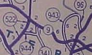 |
|
| SC 944 not currently assigned | |||
| Previous SC 944's: | SC 944: Appeared in 1941 or 1942 as new primary routing. Ran 2 miles between SC 522 and SC 341 (current S-29-26). In 1948, SC 944 was downgraded to S-29-47. | |
|
| SC 945 not currently assigned | |||
| Previous SC 945's: | SC 945: Appeared in 1941 or 1942 as new primary routing. Ran 2 miles from SC 9 Adamsburg south to SC 91 (current SC 49) in Union County. In 1948, SC 945 was downgraded to S-44-26. |  |
|
| SC 946 not currently assigned | |||
| Previous SC 946's: | SC 946: Appeared in 1941 or 1942 as new primary routing. Ran from SC 901 to SC 5 (current S-46-6) Lesslie, then 4 more miles northeast near today's Catawba Indian Reservation. In 1948, SC 946 was downgraded to S-46-31. 946 was the highest primary route number ever used in South Carolina and came in at 8 miles long. The 1946 Mobilgas of NC/SC mislabels this as SC 964. | 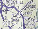 |
|
Last Update: 10 December 2004
Previous: SC 920 - 929 |
Next: SC 1 - 9
Top | South Carolina Hwy Index
Home