< US 501 | Home | US 601 >
|
|
|
| ROUTE LOG |
US 17: 0 - 0 US 17 ALT NB: 0.1 - 0.1 US 17 ALT SB: 9.5 - 9.6 SC 41 Bus: 8.6 - 18.2 SC 41: 1 - 19.2 Williamsburg-Georgetown Line: 0 - 19.2 SC 377: 17.1 - 36.3 US 52: 7.3 - 44 SC 375: 2.9 - 46.9 Clarendon-Williamsburg Line: 3.5 - 50.4 SC 261 EB: 3.3 - 41.4 SC 261 WB: 11.6 - 53 US 301 SB: 0.7 - 53.7 US 301 NB: 1.1 - 54.8 I-95 (exit 122), US 301 CONN: 1.8 - 56.6 Sumter-Clarendon Line: 5.2 - 61.8 US 15: 8.4 - 70.2 US 76 Bus EB, SC 763: 1.7 - 71.9 US 401: 0.3 - 72.2 US 15-521 CONN: 2.5 - 74.7 US 76, US 76 Bus END, US 378: 1 - 75.7 SC 441: 8 - 83.7 Kershaw-Sumter Line: 8.3 - 92 SC 261: 4.9 - 96.9 I-20 (exit 98): 2.8 - 99.7 US 1, US 601 SB, SC 34: 2.4 - 102.1 SC 97: 2 - 104.1 Lancaster-Kershaw Line: 15.3 - 119.4 US 521 Bus, US 601 NB: 3.1 - 122.5 US 521 Bus: 1.2 - 123.7 SC 522 SB: 5.9 - 129.6 SC 522 NB: 2.2 - 131.8 US 521 Bus: 5.7 - 137.5 SC 903: 1.9 - 139.4 SC 9 EB, SC 9 Bus: 0.6 - 140 SC 200: 1.8 - 141.8 US 521 Bus, SC 9 WB: 0.2 - 142 SC 5: 7.3 - 149.3 SC 75 WB: 2.2 - 151.5 SC 75 EB: 3.4 - 154.9 SC 160: 7.3 - 162.2 NC STATE LINE: 1 - 163.2
|
Creation: Appeared in late 1932, the same year is appeared nationally. It was attached to the entirety of SC 26, running from Georgetown to Andrews, then jogging north to Kingstree, then west to Manning, north to Sumter, Camden, Kershaw, and Lancaster, before exiting into North Carolina about where is does today, shown in 1932 as 179 miles.
| Adjustments: In 1949, US 521 was rerouted in Williamsburg County to run directly from Andrews to Salters and Greeleyville on its way to Manning. This was a replacement of the first SC 171 and some of SC 261. The old way via Kingstree became part of SC 377 and SC 261. This shaved 5 miles off US 521's route. In 1962-64, US 521 was rerouted at the Sumter-Kershaw Line to run more directly towards Camden. This left behind S-43-2, S-28-2, and an extended SC 261. Between 1965-67, US 521 received its bypass of Lancaster, and perhaps Kershaw as well. In both cases US 521 Business was left behind. I believe that in 1968, US 521 was extended south along Highmarket St to the Georgetown waterfront, then east on St. James St back over to US 17 at the Pee Dee River Bridge. I suppose this could've happened sooner, but I think when the US 17 bridge over the Pee Dee was opened around 1968, they changed its Georgetown routing as well. US 521 was signed with a double arrow from US 17 (521's current end) all through the 80's-90's. I did not see any 521 signs east of US 17, though. This extension is shown in my County Map Atlas and today is even shown on the MSN map of Georgetown. 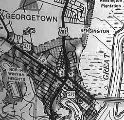
Between 1986-88, US 521 was placed on new alignment to bypass Dalzell, leaving behind S-43-1342. The last time I drove through Georgetown (January 2004), US 521 appeared to have been truncated to US 17 at Fraser St, as only a northbound arrow now exists at the 521 sign. Improvements: Paved everywhere in 1932 except between Wilson (current US 521-SC 261 split) and US 52 near Kingstree, and from Kingstree to Andrews; Wilson to Kingstree was paved in 1933; Kingstree to Andrews was paved in 1934 The first multilane sections of US 521 appeared by 1958: Its US 76 multiplex and from Lancaster north to the SC 200 split. The next section to be upgraded between 1959-64 was through Sumter to the US 15 split. In 1965-67, US 521 was 4-laned on the Lancaster Bypass. Between 1974-77, US 521 was 4-laned: from SC 200 to Andrew Jackson State Park; I-20 to SC 97; US 17 out to the railroad tracks 3 miles west of Georgetown. Between 1983-85, US 521 was 4-laned from A.J. State Park to just north of SC 75 Hancock. Between 1986-88, US 521 was 4-laned: SC 75 to the NC State Line; US 76 north to just past SC 441; Georgetown out to the US 17 ALT split. In 2001 or 2002, US 521 was 4-laned from US 17 ALT to Andrews. In total, US 521 is 4-laned on 61 miles of its route. Comment: US 521 is touted as an alternative route to the Myrtle Beach area from I-95 (via SC 261 in Manning). Most of 521 east of Manning is 2-lane, although it doesn't go through many towns. US 521 follows the Black River from the south side for a large portion of its Lowcountry routing. US 521 is North Carolina's shortest US Route. |
||||||
|
|
|
| ROUTE LOG |
US 521: 0 - 0 SC 200 SB: 2.2 - 2.2 SC 903: 0.6 - 2.8 SC 9 Bus EB: 0.1 - 2.9 SC 9 Bus WB: 0.2 - 3.1 SC 200 NB: 0.8 - 3.9 US 521, SC 9: 0.2 - 4.1
|
Creation: Appeared between 1965-67. It was of course mainline US 521 before that. | Adjustments: None Improvements: Fully paved from inception with no multilane sections. Comment: US 521 Business is Main St through Lancaster, which was once original SC 26. |
||||||
|
|
|
| ROUTE LOG |
US 521, US 601: 0 - 0 SC 341: 0.2 - 0.2 US 601 NB: 0.2 - 0.4 US 521: 0.8 - 1.2
|
Creation: Appeared in the mid 1960's? This was mainline US 521 prior.
| Adjustments: None Improvements: Fully paved from inception with no multilane sections. Comment: US 521 Business is Hampton St through Kershaw, and was once the original SC 26. The date of creation is not known, as this is not shown on any maps other than the county map I have. When I drove US 521 Bypass for Kershaw in 1989, there were still carolina style cutouts on the route, which is where I base the mid-60's guess from. 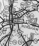 |
||||||
Last Update: 21 December 2004
Previous: US 501 |
Next: US 701
Top | South Carolina Hwy Index
Home