ROUTE LOG
US 41 ALT, TN 15, TN 56: 0 - 0
Marion-Franklin Line: 3.5 - 3.5
Franklin-Marion Line: 3.0 - 6.5
Marion-Franklin Line: 2.3 - 8.8
US 72, TN 27: 15.1 - 23.9
TN 422: 1.7 - 25.6
TN 377: 3.9 - 29.5
I-24 (exit 161): 5.2 - 34.7
TN 134: 0.4 - 35.1
|
Creation: Appeared in 1957 or 1958 running from US 72 (now 3rd at Cedar) South Pittsburg to TN 134 Haletown.
Adjustments: In 1968, TN 156 was rerouted as part of the Nickajack Lake creation, moving generally closer to where the Tennessee River was. Most of the old route is under water but small parts of today's TN 377, Mapleview Rd and Macedonia Rd exist that were part of TN 156.
It also appears that around this time that TN 156 bypassed Ladds, leaving behind Old Shellmound Rd and Ladds Switch Rd
In 1981, TN 156 in South Pittsburg was rerouted to its bridge over the Tennessee River to meet Cedar Ave further north. Previously, TN 156 used 3rd St east to Ferry Rd then after the ferry used Rivers Landing
About 1983, TN 156 was extended south with US 72 (Cedar Ave) ito central South Pittsburg, then west and north to end at US 41A Sewanee.
Posting: Posted as secondary routing throughout
Secret US Route Overlay: None
Comment: Runs across the edge of nickajack Lake and its recreational opportunities.
Traverses Franklin-Marion State Forest at its other end.
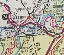
TN 156 from S. Pittsburg to Haletown
1971 Official
|
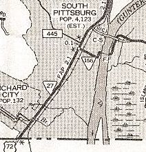
TN 156 old and new routing at the Tennessee River
1979 Marion County
|
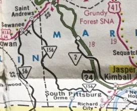
TN 156 extended west to Suwanee
1986 Official
|
|