I-26
< 20 | Home | 36 >
| I-26 71 miles | |||
| The Road: |
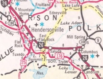
Begins at the South Carolina State line below Tryon (Polk County) and ends at the Tennessee State Line near Faust (Madison County).
Nationally I-26 runs from US 17 Charleston, SC to US 11W Kingsport, TN. |
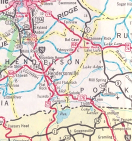
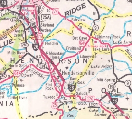
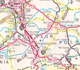
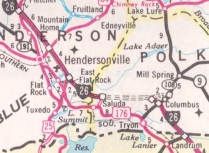
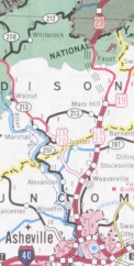
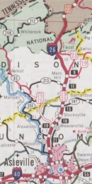
Towns and Attractions: | Polk Co.: Tryon, Saluda Henderson Co.: Hendersonville Buncombe Co.: West Asheville, Asheville, Weaverville Madison Co.: Mars Hill |
History: |
I-26 was an original 1957 interstate that first appears on the 1964 Official as dotted lines from US 25 south of Hendersonville north to NC 280 (now NC 146). It appears the I-26 corridor was first assigned as NC 296 in the original 1946 approval for interstates in North Carolina.
Many of the following timelines are from North Carolina's I-26 entry on their 50th anniversary of interstates website. I-26's first open segment arrived in 1966 from NC 280 (now NC 146) Skyland south to the US 25 Connector (now US 25) near East Flat Rock.
In 1969, I-26 was opened from I-40 Asheville to NC 280 (now NC 146) and also from NC 108 to the South Carolina line. In 1973, I-26 was opened from the US 25 Connector to the Saluda exit. In 1976, I-26 was opened from the Saluda exit to NC 108, completing the original I-26 routing in NOrth Carolina.
In 2003, I-26 was extended "west" over I-240 into Asheville, then north with US 23 to the Tennessee State Line when the older US 23 freeway was opened north of Mars Hill. Note that from I-240 north to Mars Hill the freeway doesn't meet all interstate standards and is technically FUTURE I-26.
|
Comments: |
All the exit numbers from I-40 to South Carolina were renumbered following I-26's extension to Tennessee.
I-26 is supposed to eventually get some newly constructed alignment in the Asheville area to avoid the area around I-240 and its French Broad River with two tight interchanges on either end. NCDOT has a website covering this planned work. The I-26 bridge over the Green River is reported as the tallest bridge in North Carolina. North of Mars Hill the interstate reaches over 3000 feet in elevation for a few miles and maxes out over 3700 feet. John Lansford put together a comprehensive personal website that followed the progress of I-26 construction north of Mars Hill including lots of photos - link. In 2013 NCDOT resurrected the idea of widening I-26 from Asheville to Flat Rock, which had been planned 10 years prior but stopped by legal challenges. One of my earliest travel memories was taking a trip to Asheville from Charleston, SC and having to use US 176 between Tryon and Saluda because the last bit of I-26 wasn't open yet. |
Exit List: |
EXIT 3: US 23-A
EXIT 9: US 19 NORTH, US 23-A EXIT 11: NC 213 EXIT 13: SR 2148 Stockton Rd EXIT 15: NC 197 EXIT 17: SR 2207 Old Mars Hill Hwy EXIT 18: US 19 Bus EXIT 19: US 25 NORTH, US 70 WEST EXIT 21: US 19 Bus EXIT 23: US 25 SOUTH EXIT 24: SR 1684 Elk Mountain Rd EXIT 25: NC 251 NO EXIT # (WB only): SR 1477 Hill St EXIT 4A: I-240 EAST, US 70 EAST, US 74-A EAST EXIT 3: US 19 SOUTH, US 23 SOUTH, US 74-A WEST EXIT 2: US 19 Bus SOUTH, US 23 Bus SOUTH EXIT 1C (WB only): SR 3556 Amboy Rd EXIT 1B: NC 191 EXIT 31 (old 1): I-40, US 74 WEST EXIT 33 (old 2): NC 191 EXIT 37 (old 6): NC 146 EXIT 40 (old 9): NC 280 EXIT 44 (old 13): US 25 NORTH, US 25 Bus EXIT 49 (old 18): US 64 EXIT 53 (old 22): SR 1722 Upward Rd EXIT 54 (old 23): US 25 SOUTH EXIT 59 (old 28): SR 1145 Ozone Dr EXIT 67 (old 36): US 74 EAST, NC 108 |