I-74
< 73 | Home | 74 TEMP | 274 | 77 >
| I-74 151 miles in four sections | |||
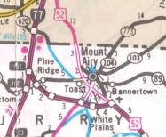
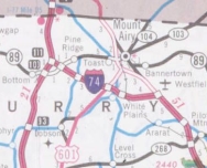
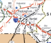
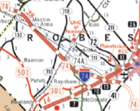
| The Road: | Begins at the Virginia State line near Mt. Airy (Surry County) and ends at NC 41 near Lumberton (Roberson County). | Towns and Attractions: | Haywood Co.: Pisgah Nat'l Forest, Clyde, Canton Surry Co.: Mt. Airy Stokes Co.: King Forsyth Co.: Winston-Salem Guilford Co.: High Point Randolph Co.: Randleman, Asheboro Montgomery Co.: Biscoe, Candor Richmond Co.: Ellerbe, Rockingham, Hamlet Scotland Co.: Laurinburg Robeson Co.: Maxton, Lumberton |
History: |
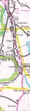
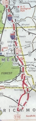
I would be foolish to suggest you get your detailed information about the progress of I-74 from anywhere other than Bob Malme's I-74 website. But for completeness of the NCroads Annex I present the basics here... Some information below comes from the aaroads.com interstate guide. The I-74 corridor was first created by the National Highway Designation Act of 1995. North Carolina first applied for the use of the I-74 designation in April 1996. In Sept 1996 (NCDOT), I-74 was assigned to the newly constructed freeway between US 220 ALT near Steeds to US 220 Business near Ulah. In Feb 2000 (NCDOT), I-74 replaced NC 752 from I-77 to US 52 in the Mt Airy area and was also assigned to I-77 north to the Virginia line.
In Nov 2000, I-74 FUTURE was signed on the US 74 freeway bypassing Rockingham and Hamlet. The 2011 official was the first to show this. In summer 2007, I-74 was signed on the Laurinburg and Maxton bypasses, then deposted in 2009. In Dec 2009 (NCDOT), I-74 was added to the newly completed freeway from the east end of the US 74 Maxton bypass to US 74-A near I-95, then added to existing US 74 east to NC 41.
In July 2011 (NCDOT), I-74 was approved by FHA to be assigned to the newly constructed freeway from US 220 Emery to US 220 south of Ellerbe.
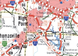
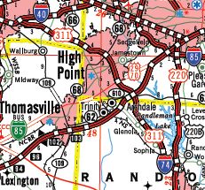
In Oct 2012 (NCDOT), I-74 was added to the existing US 311 freeway from I-40 near Winston-Salem southeast around High Point to US 29-70, then as new freeway to SR 1928 Cedar Square Rd. In Nov 2012, NCDOT requested that I-74 be assigned to the new freeway from SR 1928 to I-73/US 220 upon its completion. This freeway opened in June 2013 as is signed as I-74.
In June 2018, I-74 was extended further south along existing US 220 to the north end of the future Rockingham bypass. In January 2025, I-74 was extended around Rockingham to US 74, then posted along some of US 74 towards Hamlet. Three exisitng roadways are also going to be part of I-74: US 52 from the current end of I-74 south to NC 74; all of NC 74; US 74 from NC 41 to roughly NC 211 Bolton. In June 2026, I-74 was deposted from the unfinished Winston-Salem Beltway to I-40 and replaced by NC 192. Also, I-74 was signed on the portion of the beltway between US 52 and US 421/NC 150, replacing NC 74. |
Comments: |
Note that I-74's overlay with I-73/US 220 uses I-73 mileage for exit numbers at this writing. I-74 will definitely be completed through North Carolina. Originally conceived to connect to I-74 at Cincinnati, it seems unlikely I-74 will be signed outside of North Carolina in my lifetime. Virginia's segment just followd I-77, but West Virginia would follow US 52 which is being upgraded but not to interstate standards. Kentucky has shown zero interest in what would be their section. |
Exit List: |
|