| I-77 105 miles |
|
|
|
|
| The Road: |
|
Begins at the South Carolina State line near Pineville (Mecklenburg County) and ends at the Virginia State Line near Mt. Airy (Surry County).
Nationally, I-77 runs from I-26 Cayce, SC to I-90 Cleveland, OH
|
Towns and Attractions: |
|
Haywood Co.: Pisgah Nat'l Forest, Clyde, Canton
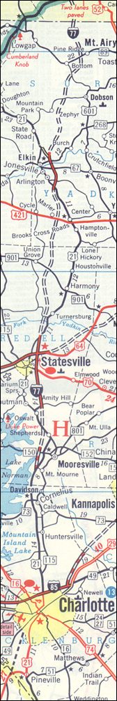
Mecklenburg Co.: Pineville, Charlotte, Huntersville, Cornelius, Davidson
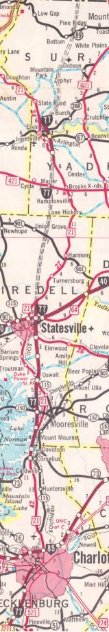
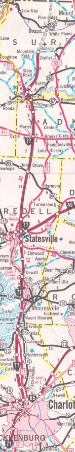
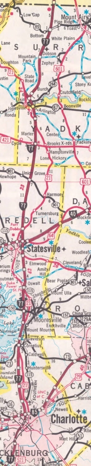
Iredell Co.: Statesville
Yadkin Co.: Jonesville
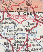
Surry Co.: Elkin
|
History: |
|
Many of the following timelines are from North Carolina's I-77 entry on their 50th anniversary of interstates website.
I-77 was created as a renumbering of I-79 between April and June 1958. I-77 was slated to run from I-85 north to Virginia via Statesville and Elkin. The original routing north of Elkin had I-77 climbing the mountain in North Carolina and entering Virginia in the NC 89 Low Gap area. The first explicit I-77 labeling came with the 1962 official (Elkin bypass).
In late 1960, I-77's routing north of Elkin was changed to its current alignment to Fancy Gap with the mountain climb in Virginia. The 1962 Rand McN showed the original proposed routing.
In June 1963, I-77 was requested by NCDOT to be extended from I-85 south to US 74 Independence Blvd. This extension was approved in Oct 1964.
In 1966, I-77 opened from SR 2342 Troutman to US 21 north of Statesville and also on the US 21 overlay bypassing Jonesville/Elkin.
In Nov 1968, I-77 was requested by NCDOT to be extended to the South Carolina line by being added to the already funded and under construction US 21 relocation south of central Charlotte.
In 1969, I-77 was open from Cornelius to the US 21 NORTH exit near Mooresville; also from US 21/NC 115 to SR 2432.
In 1971, the gap between US 21 and US 21/NC 115 opened.
In 1972, I-77 was opened from what is now I-277/NC 16 to South Carolina.
In 1974, I-77 was opened from US 421 north to the Elkin Bypass.
In 1975, I-77 was opened from US 21 Statesville to US 421.
In 1976, I-77 was opened from NC 16 to Cornelius; also from the Elkin Bypass north to SR 1001 Dobson.
In 1977, I-77 was opened from Dobson to Virginia, completing I-77.
|
I-77 proposed further west
1962 Rand McN
|
I-77 open Elkin and Statesville
1966 Gen Draft
|
I-77 open Mooresville and S. Charlotte
1972 Official
|
I-77 open N. Charlotte and N. Iredell
1977 Official
|
I-77 fully finished
1978 Official
|
|
Comments: |
|
I-77 has an unusual interchange with I-85...the NB and SB lanes of I-77 switch sides through the interchange.
|
Exit List: |
|
EXIT 1A: SR 1128 Westinghouse Blvd
EXIT 1B: I-485
EXIT 3: SR 1138 Arrowood Rd
EXIT 4: SR 1168 Nations Ford Rd
EXIT 5: Tyvola Rd
EXIT 6: NC 49
EXIT 7: Clanton Rd
EXIT 8 (NB only): Remount Rd
EXIT 9A (SB only): NC 160
EXIT 9B-C: I-277, US 74
EXIT 10A (SB only): US 29, NC 27
EXIT 10B-C: Trade St/5th St
EXIT 11: I-277, NC 16
EXIT 12: LaSalle St
EXIT 13: I-85
EXIT 16: US 21 NORTH
EXIT 18: NC 24
EXIT 19: I-485
EXIT 23: SR 2136 Gilead Rd
EXIT 25: NC 73
EXIT 28: US 21 SOUTH
|
EXIT 31: SR 2158 Griffith St
EXIT 33: US 21 NORTH
EXIT 35: SR 1100 Brawley School Rd
EXIT 36: NC 150
EXIT 42: US 21, NC 115
EXIT 45: SR 2432 Amity Hill Rd
EXIT 49A: US 70
EXIT 49B: SR 2340 Salisbury Rd
EXIT 50: SR 2321 Broad St
EXIT 51: I-40
EXIT 54: US 21
EXIT 59: SR 1890 Tomlin Mill Rd
EXIT 65: NC 901
EXIT 73: US 421
EXIT 79: US 21 SOUTH, US 21 Bus
EXIT 82: NC 67
EXIT 83 (NB only): US 21 NORTH
EXIT 85: NC 268
EXIT 93: SR 1001 Zephyr Rd
EXIT 100: NC 89
EXIT 101: I-74 EAST
|
| |
|