| N.C.
10 49 miles |
|
|
|
|
| The Road: |
|
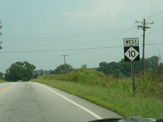
Begins at NC 226 at Polkville (Cleveland County) and ends at I-40 Exit 138 near Catawba (Catawba County).
|
Towns and Attractions: |
|
Cleveland Co: Polkville
Lincoln Co: None
Catawba Co: Newton
|
History: |
|
NC 10 was initially part of the great Central Highway and designated as an original numbered state route about 1921. NC 10 was the cream of the crop as far as state routes go in the early days.
In October 1924 (NCDOT), NC 10 was removed from three loops north of Beaufort: SR 1165 Russells Creek Rd; SR 1161 Tuttles Grove Rd/SR 1705 Core Creek Ct; SR 1160 Hardesty Loop Rd
In April 1926 (NCDOT), NC 10 was removed from
Also in April 1926 (NCDOT), NC 10 was removed from SR 1761 in Pine Grove and SR 1746 Greenfield Heights Blvd/SR 1745 Miller Blvd north out of Havelock.
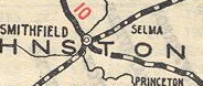
In 1926, NC 10 was rerouted at Smithfield to head north with NC 22 (now US 301/NC 96) to near Selma, then east as new construction to Pine Level and Princeton. The old route became unnumbered for nearly 30 years before becoming US 70 again (now US 70 business).
 N.C. 10 goes to Smithfield only, 1925
1925 Official
|
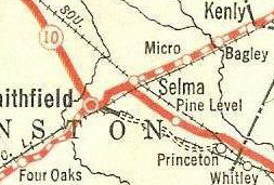 N.C. 10, Smithfield and Selma, 1926
1926 Official
|
Now, a look at the 1921-34 routing of NC 10, North Carolina's Backbone. We will look at NC 10 from a geographic standpoint rather than a chronological view.
Georgia State Line to Asheville
NC 10 entered the Tar Heel State from Georgia south of Murphy, proceeded to Murphy, then northeast through Andrews, Bryson City, Whitier, Dillsboro, Sylvia, Waynesville and Canton before reaching Asheville.
The 1926 Rand McN Auto Trails scan below shows most of this routing.
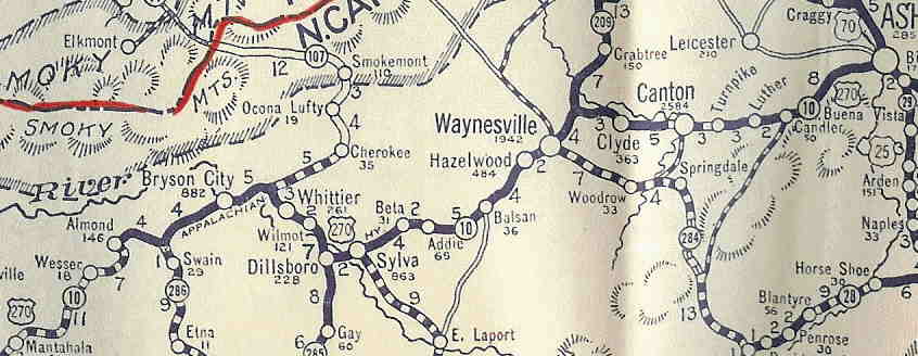
It does not appear that NC 10 in this segment had any routing changes of note.
In 1927, US 19 was assigned to all of NC 10 from Georgia to Asheville (this was initially considered as US 270 first). US 19 was still assigned to all of this when NC 10 was dropped in 1934.
Today the route of NC 10 is approximated by: US 19-129 from Georgia to Bellview; Martins Creek Rd to Murphy; US 19 Business through Murphy; Old State Rd through Regal and Marble; US 19 Business through Andrews; US 19 from Andrews to NC 28; NC 28 west to Almond; old NC 10 went north from Almond and is now under water...pick old NC 10 back up at Lower Alarka Rd to Bryson City (for a mpa showing US 19 moving alignments look at map #2 on the US 19 page; Valley Rd through Ela, Whittier and Wilmont; US 23 Business through Sylva; Skyline Dr through Beta and Addie; US 23-74 through Willets; "Old US 19A-23" through Saunook; US 23 Business through Waynesville; Broad St through Lake Junaluska, Clyde and Phillipsville; US 19-23 through Canton; "Old US 19-23" through Luther; US 19-23 through Candler; US 19-23 Business through West Asheville; Haywood Road into Asheville.
Asheville
NC 10 initially used Haywood St across the French Broad River, then down Depot St a little before using Jefferson St to Patton Ave to downtown Asheville. NC 10 turned south onto Broadway then to Biltmore Ave to leave Downtown Asheville, then east on Swannanoa Ave out to the Oteen area.
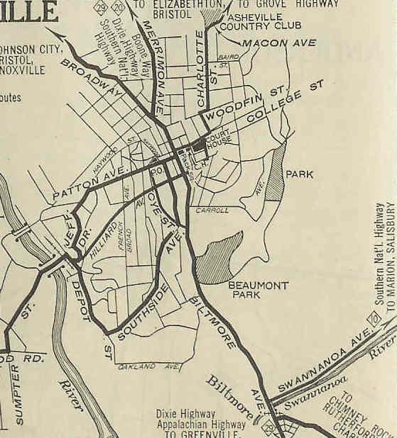
In 1927, US 19 was assigned to NC 10 east into Asheville, while US 70 was assigned to NC 10 from Asheville eastward.
In 1932, US 70 and NC 10 split up in the Asheville area. NC 10's routing did not change, while US 70 was routed through Beaucatcher Tunnel. NC 10 was still paired with US 25 on Biltmore Ave, but solo NC 10 on Swannanoa over to today's US 74-NC 81 jct.
It does not appear NC 10 used any other Asheville routing although 1934 maps show US 70 put back with NC 10 with US 74 rerouted to use the tunnel.
In 1934, NC 10 was dropped in favor of US 19 and US 70. Today, a lot of the city routing within Asheville is not primary route except for NC 81.
Asheville to Hickory
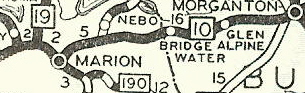
NC 10 headed east from Asheville to Black Mountain, Old Fort, Marion, Morganton and Hickory.
In 1925, NC 10 was given new routing to approach Marion from Old Fort, clearly shown on NC Official Maps of 1924 and 1925. This left behind today's "Old NC 10":
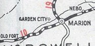 N.C. 10, original Marion approach
|
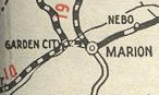 N.C. 10, new Marion approach
|
In 1927, US 70 was assigned to the entirety of this segment of NC 10.
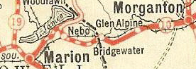
It appears that in 1929 or 1930, US 70/NC 10 was given a straighter alignment from Marion to Nebo, leaving behind Memorial Park Dr.
 N.C. 10, original east of Marion
|
 N.C. 10, new route east of Marion
|
In 1934, NC 10 was dropped from US 70. Today, to follow old NC 10 this is approximated by NC 81; US 70 to Oteen; "Old US 70" through Swannanoa to Black Mountain; Yates Ave through Ridgecrest; Mill Creek Rd to Old Fort; US 70 through Marion, Nebo and Glen Alpine; US 70 Business through Morganton; US 70 to Hickory.
Although it appears Jamestown Rd could have been an older alignment of NC 10, the 1922 Auto Trails Map clearly shows NC 10 through Glen Alpine.
Adam Prince has a nice profile of the old piece of NC 10 between Black Mountain and Old Fort and also has a feature on Point Lookout in the same area.
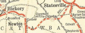
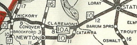
Hickory to Greensboro
NC 10 ran from Hickory to Conover, then to Newton, Statesville, Salisbury, Thomasville, High Point to Greensboro.
In 1927, US 70 was added to this entire segment of NC 10..
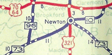
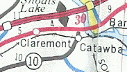
Maps seem to conflict upon the year of the following change but about 1928, NC 10 was rerouted between Newton and Statesville. Initially, NC 10 followed today's NC 16 southeast to Claremont Rd north to today's NC 10 to near Catawba, then used Hudson Chapel Rd and Buffalo Shoals road through Kyles Crossroad to Statesville, picking up Front St.
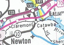
The new NC 10 used today's NC 10 from Newton to Catawba, then today's US 70 to Statesville. This change also took US 70 off NC 10 from Hickory to Catawba, following the new NC 110 and leaving solo NC 10. Except for the small piece of NC 16 out of Newton, none of this has been primary since.
 N.C. 10, original Newton-Statesville
|
 Rerouted N.C. 10, Newton-Statesville
|
The only other noticeable change to this segment of NC 10 occurred in 1933 when US 70 was removed from it through High Point along a new routing around the north part of town ( a new NC 10-A), but US 29 remained paired with NC 10.
In 1934, NC 10 was removed from all the US Route duplexes of US 70 and US 29, but the NC 10 solo piece remained from Newton to Catawba. The changes that came to this surviving bit of NC 10 are outlined at the top of this page.
To follow old NC 10 from Hickory to Greensboro today, you would use 1st Ave SW through Hickory, and Highland Ave NE to Conover; NC 16 from Conover to Newton; NC 10 Newton to Catawba; US 70 to Statesville; Front St and Salisbury Rd through Statesville; US 70 to Elmwood; a brief "Old US 70"; Bakers Mill Rd through Cleveland and Barber; US 70 from about NC 801 to US 601; Statesville Ave and Mahaley Dr. to US 29-70 in Salisbury; US 29-70 to the Yadkin River; Salisbury Rd to Lexington; Main St through Lexington; Atlantic St to Thomasville; Main St through Thomasville; Blair St to High Point; English St, Main St and Montelieu Sts through High Point; Greensboro Rd and Main St to Jamestown; High Point Rd through Sedgefield to Greensboro.
Adam Prince profiles the still-used Yadkin River Bridge from NC 10's time.
This segment of NC 10 had one of the interesting stories of developing North Carolina's highway system. The 1931 book, The State Highway System of North Carolina: Its Evolution and Present Status by Cecil Kenneth Brown has a lot of information about the mechanics of putting together and expanding the highways of the Tar Heel State. The book is available for certain at the Virginia State Library as well as the New York State Library. The Virginia State Library's copy had a 1930 Official Map and the 1921 Official Map with it!
Matt Steffora on the original NCRoads.com summarized some of the book's contents as it related to NC 10, the Central Highway. His research is presented here as an argument over NC 10 in the Conover-Newton area is discussed in the book.
From Steffora:
The idea of a single highway stretching from one end of North Carolina
to the other precedes any numbering scheme or state-level highway planning.
Occasionally early roads received state funding, but before 1921, most
roadbuilding was done by the counties, between which there was little coordination.
Figurehead State Highway Commissions existed from 1901-03 and from 1915
onward, but their duties were mostly limited to advisory and oversight
of county roadbuilding, not on actual road construction.[1]
The Central Highway was the perfect crusade for the Good Roads supporters,
because it ran through every part of the state, and went through most of
its major cities including the capital:
-
One of the most important steps taken in this direction
[statewide road planning] was the creation by the legislature in
1911 of the Central Highway. This was by no means a highway in any practical
sense of the word, but was only a projected route for travel through the
state. The route was to begin at Morehead City and go through the state
from east to west by way of Raleigh, Greensboro, Salisbury and Asheville.
All the way it followed closely the line of railroad built by the state
in the middle third of the last century. That route, long ago broken up
into several routes with various directions, was built on a most circuitous
survey. But the Central Highway followed its sweeping curves and even today
[1931] the magnificent state route number 10 takes the same roundabout
course from the seashore to the Tennessee [sic] line. In 1911 a
Central Highway Committee was appointed with the function of designating
the route in detail, and getting the various counties to cooperate in building
it through from one end of the state to the other. The idea was to show
people what a highway trip through the state would mean. Every year the
committee made a trip over the route, traveling by automobile, exhorting
the people to good works and telling them what the other counties were
doing.... Soon there was a vast number of such paper highways.... These
were roads with ringing names, no matter how ephemeral their substance
was. They furnished rallying points for the good roads sentiment.[2]
(If the "magnificent state route number 10" is a comment on the number
rather than on the road, it is likely the first rhapsodization over a highway
number in recorded history.)
The second State Highway Commission of 1915 and the third Commission
of 1919 were mainly charged with the task of "surveying and mapping those
routes which in its estimation ought ultimately to be incorporated into
a state system."[3] The Central Highway, entering the state near Murphy
and ending at the coast, naturally became the centerpiece of this system.
The dream of building it as more than an agglomeration of many smaller
roads finally came true in late February 1921, with the passage of $50
million in roadbuilding bonds and the formation of the fourth State Highway
Commission.
The designation of the Central Highway as route number 10 affirmed it
as top dog among the state's roads. Under North Carolina's original
highway numbering system, the most important routes received low numbers
and/or multiples of 10, but single digits went unassigned. Although a few
major cities such as Charlotte and Wilmington were not served by the Central
Highway, the majority of North Carolinians used at least some part of 10
in traveling any considerable distance within the state.
By mid-1924, about half of the Central Highway was paved, and the remainder
was improved clay or gravel. By the end of 1926, almost all of it was paved.
The exceptions were one stretch between Marion and Old Fort, another at
its eastern end near Beaufort and a segment near Newton where the alignment
had not yet been finalized.
The Newton Case. One of the state's earliest road controversies
involved the location of N.C. 10 in the Newton area. The 1921 roads bill
(and the prior 1915 legislation authorizing the second Highway Commission)
called for primary highways to connect every neighboring county seat; Newton
is the seat of Catawba County. The Central Highway was planned to somehow
run from Statesville, the seat of Iredell County to the east, west to Hickory,
the largest city in Catawba County, and on towards Morganton, the seat
of Burke County. The most direct route from Statesville to Hickory would
have missed Newton completely to the north. A number of different routings
for the Central Highway through Newton were considered as a remedy (image
below).
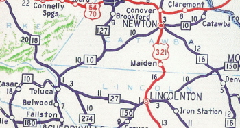
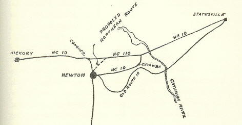 Alignment of 10 and 110 in 1931, along with original ("old")
10 and abandoned Northern Route proposal. Road south of Newton is original
N.C. 16. [4]
Alignment of 10 and 110 in 1931, along with original ("old")
10 and abandoned Northern Route proposal. Road south of Newton is original
N.C. 16. [4]
The 1921 bill provided immediate funding to pave only part of the Central
Highway in this area. The stretch from Newton north to Conover and west
to Hickory was chosen first. (Today, this routing is signed as N.C.
16 from Newton north to Conover and SR 1007 from Conover west to Hickory.
SR 1007 has two names, Highland Avenue Northeast and/or Old U.S. 70.) Money
was not immediately available to build or pave anything east of Newton.
In the meantime, the Central Highway east of Newton was run over a circuitous
route well to the south of the modern 10 and the settlement of Catawba.
The original routing probably went along modern Hudson Chapel Road (SR
1004) in Newton County, and modern Buffalo Shoals Road (SR 1004) in Iredell
County. It may have also run over Bandys Creek Road (SR 1813), Long Island
Road (SR 1833) and N.C. 16 in Catawba County. These roads would have carried
10 until at least 1926, while debate raged over building a shorter route
between Statesville and Hickory.
A direct route straight east out of Newton toward Statesville was precluded
by the existence of a deep ravine east of Newton into which several creeks
drain. The original 10 stayed to the south of this ravine. The state highway
commissioner for Newton's district, W.C. Wilkinson, first proposed that
the new 10 run straight from the Catawba River west to Conover, missing
Newton entirely (this is what U.S. 70 does today). While this route would
have been the most expedient for through travelers, Newtonians decried
the possible loss of commerce to their city and the disrespect shown it
as a county seat. The Highway Commission as a remedy proposed an alternative
"northern route", which would have run due west from the Catawba River
before tacking southwest along the Southern Railway line into Newton, then
doubling back north along the already-paved 10 to Conover (see image above).
A third option that was considered, the eventual modern 10 east of Newton,
would have been 1.4 miles longer and $200,000 more expensive to build than
the Northern Route.
Newtonians opposed the Northern Route as well, because then 10 would
only graze the city limits rather than pass in front of the courthouse.
Under the Northern Route plan, a state highway would still run through
downtown Newton and past the courthouse. But it would have been N.C. 16,
which was apparently not sufficient for the locals, who wanted their 10.
The issue boiled down to the interests of locals versus those of through-travelers.
The locals won -- sort of. Newton took the Highway Commission to court,
obtained a restraining order against building the Northern Route in April
1926 and eventually prevailed in the state Supreme Court that May. State
Highway 10 would have to go by the Newton courthouse.
But the state ended up building two new roads. A new Catawba River crossing
was built well north of the original 10, and just west of the river the
road forked. One road jogged south into the village of Catawba before running
southwest into Newton. This road became the "new" N.C. 10, and is still
part of 10 today. The other road followed Wilkinson's original intent,
running due west to Conover and bypassing Newton entirely. This road was
first numbered as N.C. 110; today it's part
of U.S. 70. Both 10 and 110 were paved in early 1929 (they show up unpaved
on a 1928 map). "So Newton has its road through the center of town and
the rest of the state has its through route that is nearly six miles shorter.
Present traffic conditions by no means require the duplication. To satisfy
Newton the state built ten miles of concrete roadway at a cost of a quarter
of a million dollars."[5] The Northern Route was never built.
Although Newton won its battle, it probably lost the war. The locals'
goal was to get out-of-towners to "stop for a sandwich or a tank of gasoline....
Perhaps some of them would be so enchanted as to take up residence there
and maybe start a factory. At least they could see her civic beauties and
spread her fame around as they journeyed on."[6] But through-travelers
could blow off Newton on 110.
By 1930, 110 was renumbered to 10A (see below), as if the state's preference
hadn't been made clear enough already.
Sources as cited by Steffora:
[1] Cecil Kenneth Brown, Ph.D. The State Highway System of North
Carolina: Its Evolution and Present Status. Chapel Hill, N.C.: UNC
Press, 1931. 54-55.
[2] Brown 57-58.
[3] Brown 152.
[4] Brown 157.
[5] Brown 161.
[6] Spencer Murphy, editorial in Salisbury [N.C.] Evening Post,
as quoted by Brown 159.
Generally, information about the Newton controversy taken from Brown
156-161.
Greensboro
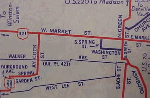
NC 10's routing through Greensboro remained the same throughout the early period: High Point Rd to Lee St (current NC 6) to Fairground Ave, then Spring Garden St. to Aycock St to West Market St., where NC 10 exited to the east before meeting up with today's Wendover Ave near I-840. This is shown as US 70 on the scan below.
Greensboro to Raleigh
NC 10 ran from Greensboro to Elon College, Burlington, Graham, Hillsboro, Durham, Cary before heading into Raleigh.
In 1927, US 70 was added to all of this segment of NC 10.
In 1929 or 1930, US 70/NC 10 was given a southern bypass of Gibsonville and Elon College over new routing. The old route through these towns became NC 100 and then NC 10A (today this is NC 100 and the old 100 through Elon College on Haggert St). Also, US 70/NC 10 was rerouted to the north of Graham on its way to Mebane. Burlington to Graham became NC 54 (now NC 87) and Graham northeast out towards mebane became NC 62 (now NC 49).
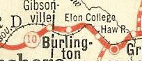 N.C. 10 goes through Gibsonville, 1926
|
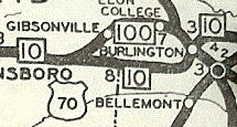 N.C. 10, bypassing Gibsonville, 1930
|
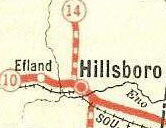
It appears that by 1930, US 70/NC 10 was given a new routing east of Hillsborough to about NC 751. The old route through University became a small piece of NC 14 (now NC 86) and what is today an "Old NC 10." This segment of old NC 10 in Eastern Orange County is profiled by Adam Prince.
 N.C. 10 and N.C. 14 duplex, 1926
|
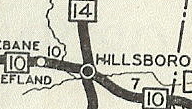 N.C. 10, directly east from Hillsborough, 1930
|
NC 10 did not receive any adjustments within Durham or from there to Raleigh.
To follow the last route of NC 10 through this segment, use Wendover Ave east of Greensboro to US 70; US 70 through Burlington; a small piece of old 70 and NC 49 through Haw River; US 70 through Mebane to the west end of Hillsborough; West Hill St, King St, then US 70 Business through Hillsborough; US 70 to the US 15-501 freeway; then Hillsborough Rd east to 9th St, then south to Main St., which it followed to Alston Av where it jogged one block south to Angier Ave. From there US 70 left Durham and went to Bethesda, where it veered due south on today's Miami Rd until it reached today's NC 54 at Nelson. NC 10 followed today's NC 54 to Maynard Rd in western Cary (except used Church St in Morrisville), then used Chapel Hill Rd to Durham Rd to Chatham St which becomes Hillsborough St to continue towards Raleigh
Raleigh
NC 10 initially entered Raleigh on Hillsborough St to Edenton St, then turned south and east at Capitol Square (using Salisbury and Morgan Sts) at the State Capitol onto Fayetteville St, then east on Cabarrus, then south on Bloodworth before angling SE to Garner Rd. which carried US 70 out of Raleigh.
By 1930, US 70/NC 10 US 70 used a different routing in Raleigh, using Western Blvd to Boylan Dr, then South St east to Fayetteville St north, then east on Lenoir St then south on East St and Hollman Rd. The original way became part of US 1/NC 50 approaching Raleigh, then unnumbered streets mostly downtown.
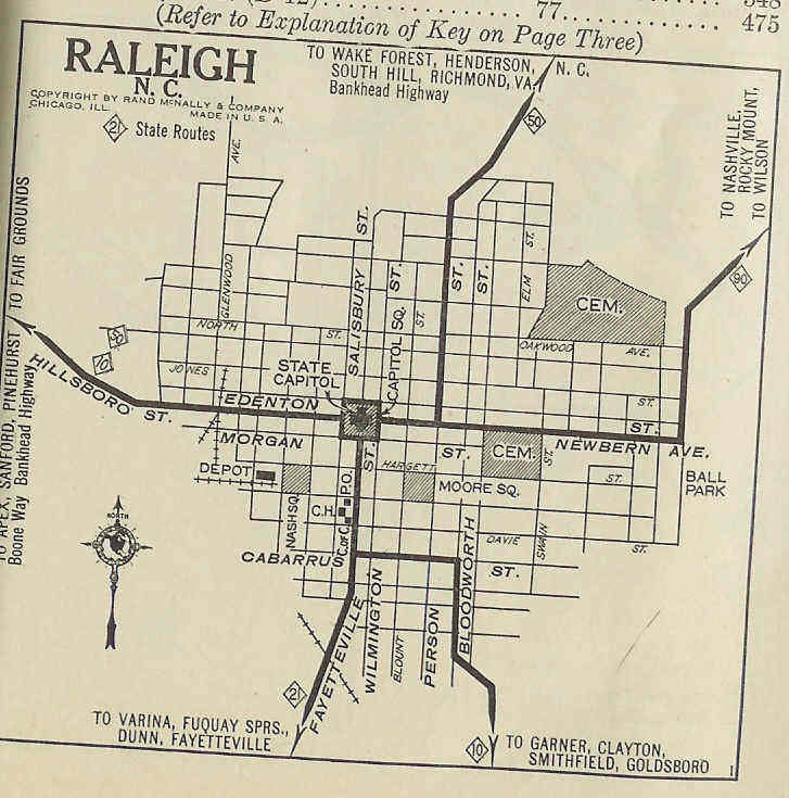 N.C. 10, original Raleigh routing
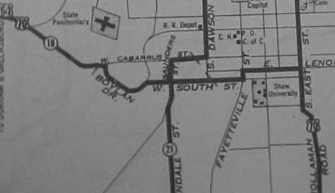 N.C. 10, final Raleigh routing
Raleigh to the Coast
NC 10 ran from Raleigh to Smithfield, Princeton, Goldsboro, La Grange, Kinston, New Bern, Havelock, and ended in Beaufort.
In 1927, US 70 was again added to this entire segment of NC 10.
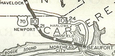
In 1928, NC 10 swapped places with NC 101, and ran from Havelock to Beaufort. The old route to Beaufort became NC 101 and NC 10 and NC 101 ended at each other.
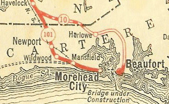 N.C. 10 goes to Beaufort only, 1926
|
 N.C. 10, Morehead City and Beaufort, 1930
|
In late 1930, NC 10 east was extended over a bit of NC 101, then as new primary route out to Atlantic.
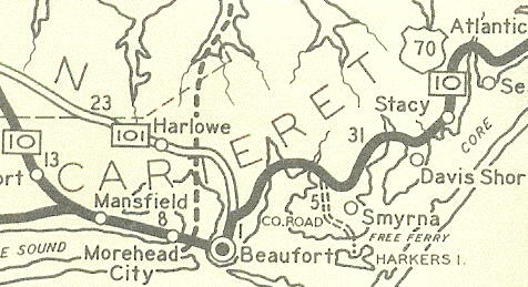 N.C. 10, east of Beaufort, 1933
In 1934, NC 10 was dropped on this segment in its entirety for US 70. Today, the last routing of NC 10 can be followed: Garner Rd through Garner and Auburn; Johnston SR 1004 and Main St. through Clayton; US 70 then US 70 Business to Smithfield; US 301 to below Selma; US 70 east to US 70-A through Pine Level to Princeton; Edwards St through Princeton; US 70 to US 13-117; US 70 Business through Goldsboro; US 70 to Lenoir Co; Washington St through La Grange; US 70 to US 258; US 70 Business into Kinston; NC 55 from Kinston through Fort Barnwell to New Bern; Broad St to George St south (NC 10 ran through what is now the Tryon Palace). On the other side of the Trent River: Old Cherry Point Rd to Riverdale; US 70 to Havelock; Cunningham Blvd and a small piece of NC 101; "old us 70" south to US 70; Chatham St through Newport; US 70 through Morehead City, Beaufort, and ending at Atlantic.
In 1934, NC 10 ran only from NC 73 (now NC 16) Newton east to US 64-70 Catawba.
In 1940 or 1941, NC 10 was extended southwest to Toluca replacing part of NC 73 and then further southwest to NC 26 (now 226) Polkville replacing part of NC 27.
NC 10: 1934-41
|
NC 10 extended to Polkville
|
Between 1951-53, NC 10 was taken off most of its NC 18 duplex to Toluca and given a more direct route southwest. This left behind solo NC 18 and the piece of NC 27 west of NC 18.
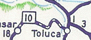
NC 10 going to Toluca
|
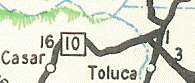
NC 10 rerouted around Toluca
|
Official maps didn't show this until the late 90s, but NC 10 was extended to I-40 from US 70 by 1990.
NC 10 stops at US 70
|
NC 10 extended to I-40
|
|
Comment: |
|
NC 10's distance on the 1933 Official Map totaled 599 miles. The original NC 10 was shown as fully paved on its entire length on the 1930 Official Map.
Today NC 10 cannot be viewed as a main route of any sort in the modern North Carolina.
The only portion of NC 10 that was also NC 10 in 1922 is what is now the NC 10-16 duplex.
In the 80s and 90s there were still original NC 10 bridges with NC 10-labeled nameplates on bypassed alignments, one in Havelock and one near Marion
Adam profiles the Central Highway here.
Thanks to S.D. Rhodes for editorial help with this page in the Raleigh area.
|