| N.C.
11 196 miles |
|
|
|
|
| The Road: |
|
Begins at US 74-76 near Freeman (Columbus County) and ends at US 158 Bus-US 258 Murfreesboro (Hertford County).
|
Towns and Attractions: |
|
Columbus Co: None
Bladen Co: None
Pender Co: Atkinson, Penderlea
Duplin Co: Kenansville
Lenoir Co: Pink Hill, Kinston
Pitt Co: Grifton, Ayden, Winterville, Greenville, Bethel
Edgecombe Co: None
Martin Co: Oak City
Bertie Co: Lewiston-Woodville, Aulander
Hertford Co: Murfreesboro
|
History: |
|
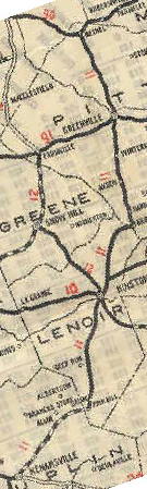
NC 11 was designated as an original numbered state route about 1921. NC 11 initally ran from NC 40 (current NC 11-50 west split) Kenansville, northeast to Kinston where it crossed its parent NC 10. NC 11 continued north through Greenville and ended at NC 90 (now US 64 ALT) Bethel.
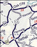
In 1929 or 1930, NC 11 was extended as new primary routing north to Oak City, via Hassell to end at NC 125.
NC 11: 1921-30
1925 Official
|
NC 11 extended to Oak City
1931 Official
|
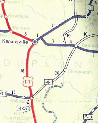
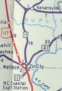
In 1940, NC 11 was extended south to Tin City replacing part of US 117 and then duplexed with US 117 a short piece, then west to the NC Coastal Experimental Station. The mile from US 117 to the Experimental Station was a replacement for NC 401.
NC 11 ending in Kenansville
1936 Official
|
NC 11 extended south of Tin City
1941 Official
|
About 1942, NC 11 was rerouted between Bethel and Oak City to its current more direct routing. The road to Oak City via Hassell became secondary, though today it is part of NC 142 to Hassell and SR 1002 to Oak City.
NC 11 in Martin County 1930-42
1938 Gen Draft
|
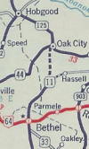
NC 11's route no longer a Hassell after 1942
1942 Gen Draft
|
Kinston changes
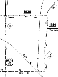
Between 1942-44, NC 11 was reoruted within Kinston. Initially, NC 11 entered on Caswell St, north on Queen St, then east on Vernon and northeast on Minerva St out of town with NC 11.
Now NC 11 duplexed with NC 55 east at Jackson Store and picked up US 258 north which is Queen St. The old route on Caswell appears to have gone unnumbered for a number of years.
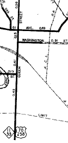
Between 1945-49, NC 11-55 was rerouted on Quuen St to King St east to East St north to Washington St east to Minerva St on out of town. The old route through central Kinston became NC 11-A.
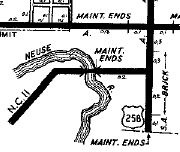
In 1952, NC 11-55 was rerouted to use King St across the Neuse River as it runs today. This left behind US 70-258 and today's SR 1341 between Jacksons Store and US 258.
Sometime after 1968, NC 11-55 was rerouted to use King to Tiffany instead of East and Washington.
NC 11 approaching Kinston from the southwest
1936 Lenoir County
|
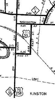
NC 11-55 through central Kinston
1944 Lenoir County
|
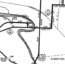
NC 11-55 rerouted away from central Kinston
1949 Lenoir County
|
NC 11-55 rerouted onto King
1953 Lenoir County
|
NC 11-55 modern routing
2007 Lenoir County
|
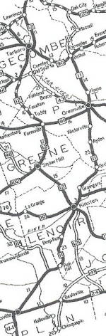
Between 1956-58, NC 11 was rerouted in Greenville to its current routing. Initially NC 11 followed Dickinson Ave to Greene St.
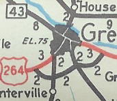
NC 11 in central Greenville
1955 Official
|
NC 11 avoiding downtown
1958 Official
|
In April 1966 (NCDOT), NC 11 was extended north as new construction across the Roanoke River to end at NC 308 Lewiston
In Nov 1967 (NCDOT), NC 11 north was extended over SR 1200 to end at NC 305 Connaritsa.
In Sept 1969 (NCDOT), NC 11 was placed on new 4-lane construction to bypass Grifton, leaving behind Highland Blvd and a small piece of extended NC 118.
In Feb 1971 (NCDOT), NC 11 was moved to its new bypass of Lewiston-Woodville. The old route became SR 1209 and SR 1204 for a while but is now NC 11 Business.
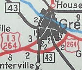
In May 1971 (NCDOT), NC 11 was placed on new 4-lane construction bypassing Ayden and Winterville, leaving behind Lee St and SR 1149.
NC 11 original alignment
1969 Official
|
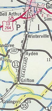
NC 11 bypassing only Grifton
1970 Official
|
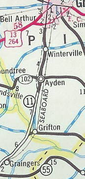
NC 11 bypassing everybody
1971-72 Official
|
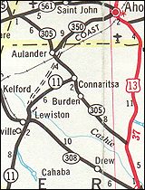
In Sept 1972 (NCDOT), NC 11 was rerouted north of Lewiston-Woodville to near Aulander (new construction), then northeast to Ahoskie as a duplex with NC 350. NC 11 then duplexed with US 13 north 2 miles before angling northwest replacing SR 1001 to US 158-258 Murfreesboro.
In April 1974 (NCDOT), NC 11 was rerouted at Tin City to follow US 117 further south, then replaced SR 1001 through Willard then SR 1321 west through Penderlea to end at US 421. The old NC 11 route from US 117 to the NC Experiment Station (not shown on officials past 1961) became SR 1357.
In Sept 1974 (NCDOT), NC 11 was extended south along US 421 south to NC 53, then with NC 53 through Atkinson to the Black River. From there, NC 11 replaced NC 141 south to US 74-76.
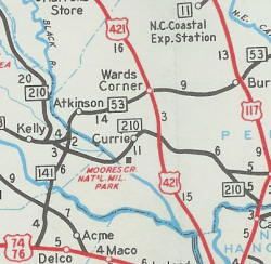
NC 141 running south to US 74-76
1954 Official
|
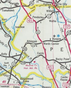
NC 11 replaced NC 141
1978-79 Official
|
In July 1979 (NCDOT), NC 11 was put on a new road bypassing Ahoskie to the west, which met the old NC 11 on its way to Murfreesboro without touching US 13. The old route south of Ahoskie became part of NC 42.
1967 Official
NC 11 heading for Lewiston
|
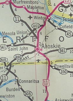
NC 11 ends at Connaritsa 1967-74
1972-73 Official
|
NC 11 extended to Ahoskie and Murfreesboro (1974-80)
1974-75 Official
|
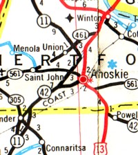
NC 11 bypasses Ahoskie, since 1980
1980-81 Official
|
In Sept 2003 (NCDOT), NC 11 was given an expressway bypass of Bethel to the east. The old route through town became NC 11 Business.
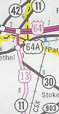
NC 11 through Bethel
2003 Official
|
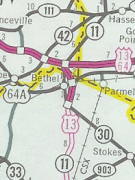
NC 11 Bus in Bethel
2004 Official
|
In Nov 2019, NC 11 was given a freeway bypass of Greenville, utikizing the existing US 264 freeway north of Memorial Dr. This new routing is signed as NC 11 BYPASS while the route through Greenville remains bannerless NC 11.
|
Comment: |
|
NC 11 offers an attractive alternative to US 13 from Bethel to north of Ahoskie, even with the US 13-64 freeway in place in Martin County. North of NC 125 the road is quite straight and empty through swampland.
NC 11 was 4-laned from Kinston to Greenville in pieces from the late 60s to 1971. North of Greenville was 4-laned in 2001 or 2002. Kinston southward to PInk Hill is also 4-laned.
Although a Kenansville bypass exists that NC 11 could use, the 2004 Duplin County map shows it as only NC 903.
NC 11 is part of Corridor 53 of the NC Strategic Vision Corridors.
|