| Formerly: |
|
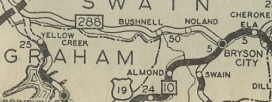
NC 288 #1: Appeared about 1929 as new primary routing, from NC 108 (now US 129), at the Tennessee State Line east to NC 10 (current US 19 and SR 1364 Everett St) Bryson City.
The last official map to show NC 288 was 1944, although the 1944 Swain County map shows the lake in place. The Little Tennessee River was dammed to make Lake Fontana. This also submerged the villages of Judson, Noland, Bushnell and Wayside.
The westernmost several miles of old NC 288 survived and became a secondary road (now some is NC 28). The easternmost few miles are a small piece of SR 1364 Everett St and SR 1321 Bryson Walk.
Portions of the rest of old 288 along the lake do exist on higher ground and are part of hiking opportunities. Matt Steffora reported that the road is discernable and there are even abandoned autos that are still there. One pice of this trail is easily reached from the Fontana Dam parking area.
The creation of this lake creates controversy that persists today, as the government promised to build a new road around the north side of the lake, where family homesteads and graveyards sit unreachable without canoes and hiking. In recent years there has been news with this as whether citizens should be paid a settlement or the state should build the road. A road was started from Bryson City that runs about 10 miles and ends at a tunnel. This is New Fontana Rd, SR 1364. Gribblenation profiles this North Shore Road here.
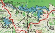
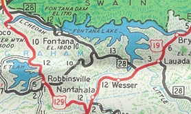
NC 288 #2: The westernmost portion of original NC 288 was revived as NC 288 about 1951, running from US 129 to Fontana. This was renumbered as NC 28 in 1954.
The number 288 is associated with lakes in the south...NC 288 with Lake Fontana; SC 288 was rerouted by Lake Jocassee; GA 288 is routed around Lake Chatuge...

NC 288 #1 appears in 1929
|

NC 288 revived in Fontana
|

NC 28 erases NC 288
|
|

