N.C. 731
< 721 | Home | 740 >
Photo:
| N.C. 731 23 miles | |||
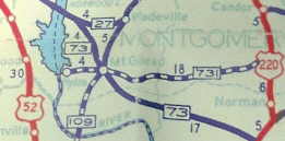
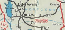
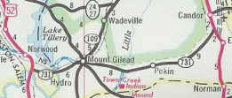
| The Road: | Begins at US 52 Norwood (Stanly County) and ends at US 220 ALT/NC 211 Candor (Montgomery County). | Towns and Attractions: | Stanly Co:Pembroke, Pembroke State Univ, Lumberton Montgomery Co: Mt. Gilead, Candor |
History: |
NC 731 was created about 1936, running from US 220 well south of Candor west through Mt. Gilead and ending at the community of Hydro along High Falls Lake.
In 1947 or 1948, NC 731's eastern end was moved much closer to Candor where it meets US 220-A today. This left behind SR 1524 Cemetery Rd. In 1975 or 1976, NC 731 was rerouted west of Mt. Gilead over new construction across the Pee Dee and over to US 52. The old route to Hydro became SR 1188.
|
Comment: |
NC 731 gets mentioned from the I-73/74, US 220 freeway at both the south end of US 220-A and also at the NC 211 interchange. |
Last Update: 24 August 2007
Previous: N.C. 721 |
Next: N.C. 740
Top | NCRoads.com
Home