< VA 266 | Home | VA 268 >
| |||||
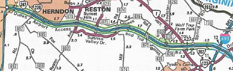
| ROUTE LOG EXIT 1 - US 15, VA 7: 0 - 0 EXIT 2 - Battlefield Pkwy: 0.9 - 0.9 EXIT 2B - Compass Creek Pkwy: 0.8 - 1.7 EXIT 3 - SR 653: 1.2 - 2.9 EXIT 4 - SR 659: 2.58 - 5.48 EXIT 5 - SR 901: 1.06 - 6.54 EXIT 6 - SR 772: 1.79 - 8.33 EXIT 7 - SR 607-1950: 1.40 - 9.73 EXIT 8 (old 7) - SR 606: 1.08 - 10.81 EXIT 9 (old 1) - VA 28: 1.72 - 12.53 Fairfax-Loudoun Line: 1.23 - 13.76 EXIT 10 (old 2) - SR 657: 0.94 - 14.70 EXIT 11 (old 3) - SR 7100: 1.77 - 16.47 EXIT 12 (old 4) - SR 602: 0.93 - 17.40 EXIT 13 (old 5) - SR 828: 1.04 - 18.44 EXIT 14 (old 6) - SR 674: 1.88 - 20.32 EXIT 15 (old 7) - SR 676: 2.21 - 22.53 EXIT 16 (old 8) - VA 7: 1.20 - 23.73 EXIT 17 (old 9) - SR 684: 0.63 - 24.36 EXIT 18 (old 10) - I-495: 1.60 - 25.96 EXIT 19 (old 11) - VA 123: 0.26 - 26.22 I-66: 2.46 - 28.68 |
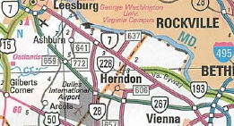
Creation: Appeared in 1984 as a new toll road that ran from VA 28 Dulles to VA 123 McLean. This is the 2nd VA 267.
Adjustments: The Dulles Access Road Extension to I-66 opened in 1985. VA 267 was extended west to US 15-VA 7 Leesburg in 1995. Improvements: Paved upon inception; 4-lane freeway upon inception, except I-495 to VA 7 was 6-laned. The 1995 extension was 6-lanes from the Dulles area toll plaza to Exit 5 By 2002, VA 267 was 8-laned from VA 28 to VA 7 and 10-laned from VA 7 to I-495. In 2008, VA 267 was 6-laned from Exit 5 north to Exit 2 Posting: Fully posted; On the approaches from both sides at US 15-VA 7, a borderless button is used on a white sign, giving an odd effect. Most of the Greenway's signs look exactly like normal road signs, although there's a few oddities as you might expect. Certain exits have special signs for housing developments. Also there seem to be a few more signs marking curves and other hazards than are absolutely necessary, such as turtle crossings. Liability limitation perhaps? :) Multiplexes: NONE Legislative names: Omard L. Hirst - Adelard L. Brault Expressway (entire route), since 3/91. Other names: Dulles Greenway (west of airport); Dulles Toll Rd (east of airport); Dulles Access Road Connector (east of I-495) Scenic Byway: No segments Comment: The VA 267 corridor began as the free Dulles Access Road, which opened in 1962 and connected Dulles Airport with VA 123. The Dulles Toll Road was built on the outside of this as the initial segment of VA 267. A rather unique road split in two distinct parts. East of Dulles Airport is the Dulles Airport Road and Toll Road. The older inner lanes are free and allow you to go only to/from the airport. The outer lanes are toll and have regular interchange access. Ramps allow access between the roadways. If you miss your ramp coming eastbound on the inner roadway be prepared to go way, way out of your way (as Dave did once, how embarrassing). Toll booths and ramps are strategically situated so that airport traffic never has to pay, while non-airport always has to pay. Some people going to the Herndon area have attempted to avoid the tolls (and rush hour traffic) by entering the airport and U-turning, but I've been told the cops are watching for this (exactly how I don't know). For a while, both the free and toll lanes were considered part of VA 267, but about 2003 the free lanes were designated internally as VA 90004. West of VA 28 is the Dulles Greenway, a privately owned and operated toll road which was opened to much fanfare in 1995, and promptly became a tremendous flop. Various theories abounded most of which had to do with the outrageous tolls and low speed limit (55 MPH). As tolls decreased, and the speed limit and local development have increased, the road's use has gradually increased The Greenway is considered part of VA 267 per the VDOT route and traffic logs. For more information on this corridor, see Scott Kozel's website here.
| ||||
| Previous VA 267's:
1951 ROUTE LOG US 340: 0 - 0 WV LINE: 2.80 - 2.80 |
VA 267 #1: Appeared in July 1933 as a renumbering of VA 823.
Ran from US 340 near Stringtown north to the WV line. This was
downgraded to SR 611 in April 1951 (CTB). The 1947 VDOT map
misidentifies VA 267 as VA 276.
| ||||
Previous: VA 266 |
Next: VA 268
Top | Virginia Hwy Index
Home
Page last modified 25 December 2023