< VA 338 | Home | VA 340 >
| |||||
|
Creation: Appeared Dec 1939 (CTB). This is the 2nd VA 339.
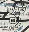
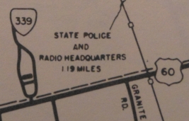
Adjustments: None Posting: None at US 60, none internally Comments: Appears on VDOT officials (on the main map, NOT in insets) from 1941-1959. Mapmikey drove this in October 2005. Only a very short segment is accessible to the public - enter, circle the first parking area (behind unmanned gate) and exit back to US 60. Outside normal business hours VA 339 is probably even shorter - a tight circle 50 feet off US 60.
| |||||
| Previous VA 339's: 1928 ROUTE LOG US 11, VA 33: 0 - 0 END VA 339: 4 - 4 |
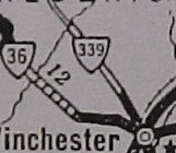
VA 339 #1: Created March 1927 (CTB) as an upgrade to CR 11,
running from US 11/VA 33 Winchester (at the corner at Picadilly and
Braddock) northwest 4 miles to the Gainsboro area.
In August 1928 this was renumbered as VA 822. Today it is part of US 522. VA 339 is shown only on the Winchester inset on the 1927 Official but is shown on the main side of the 1928 Official.
| ||||
Previous: VA 338 |
Next: VA 340
Top | Virginia Hwy Index
Home
Page last modified 26 March 2022