< VA 416 | Home | VA 418 >
| VA 417 not currently assigned | |||||||
| Previous VA 417's: 1931 ROUTE LOG VA 417: 0 - 0 VA 19: 6.14 - 6.14 1989 ROUTE LOG US 60: 0 - 0 VA 161: 1.83 - 1.83 VA 150: 1.59 - 3.42 Chesterfield-Richmond Line: 1.07 - 4.49 |
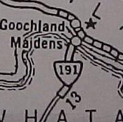
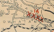
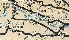
VA 417 #1: Appeared in Aug 1928 as a renumbering of VA 191 from VA 19 (now VA 6) Goochland C.H. south to VA 419 (now SR 711) Jefferson. See scan under VA 419 entry.
In Dec 1930 (CTB), VA 417 was assigned 0.80 miles from the James River bridge to VA 19. It is unclear where the original route actually was in relation to alignments visible today nor where the road before this may have hit VA 19. Satellite images suggest multiple possibilities. One theory is that VA 19 ran much closer to the river and this 0.8 miles was to get VA 417 out to the new location (where VA 6 currently runs). In 1932, VA 417 was renumbered as part of VA 419. Today it is US 522 and SR 664 south of the river. North of the river it used the SR 710/717 disconnected loop through Maidens.
|
||||||
Previous: VA 416 |
Next: VA 418
Top | Virginia Hwy Index
Home
Page last modified 15 February 2025