< SC 54 | Home | SC 56 >
|
|
|
| ROUTE LOG |
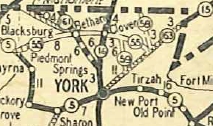
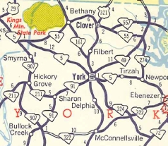
SC 5: 0 - 0 York-Cherokee Line: 0.5 - 0.5 SC 161: 7.3 - 7.8 US 321: 5.7 - 13.5 SC 557: 2.3 - 15.8 SC 49, SC 274: 5.5 - 21.3
|
Creation: Appeared in 1929 as new primary routing, running the way it does now but its western end was at today's SC 97 (then-SC 5) Kings Creek. This is the 2nd SC 55.
| Adjustments: In 1951, SC 55 west was truncated to its current endpoint at SC 5 Piedmont Springs. The road to Kings Creek became part of SC 5.
Improvements: In 1937, SC 55 was paved from Bethany to SC 557. In 1939, SC 55 was paved between SC 557 and SC 49/274. SC 55 became fully paved in 1941. SC 55 has no multilane segments. Comment: SC 55 runs across northern York county, just underneath Kings Mtn Natioanl Battlefield. | Previous SC 55's:
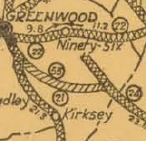
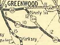
1937 ROUTE LOG SC 21: 0 - 0 SC 24: 11 - 11 |
SC 55 #1: Appeared about 1926 as new primary routing, running from SC 21 (now US 25) near Greenwood southeast to SC 24 (now SC 246) Friendship.
In 1929, SC 55 was renumbered as SC 24. Today it is part of US 178.
|
||||||||||
Previous: SC 54 |
Next: SC 56
Top | South Carolina Hwy Index
Home
Page last modified 1 January 2016