ROUTE LOG
US 276: 0 - 0
I-85 (exit 50): 3.0 - 3.0
I-385 (exit 35): 0.8 - 3.8
SC 14: 2.1 - 5.9
SC 296 WB: 1.8 - 7.7
SC 296 EB: 0.6 - 8.3
SC 417 WB: 2.6 - 10.9
Spartanburg-Greenville Line: 1.0 - 11.9
SC 417 EB: 0.4 - 12.3
SC 101 NB: 2.9 - 15.2
SC 418: 4.5 - 19.7
US 221 NB: 0.2 - 19.9
SC 101 SB: 0.9 - 20.8
US 221 SB: 0.5 - 21.3
I-26 (exit 38): 6.1 - 27.4
SC 56: 6.3 - 33.7
|
|
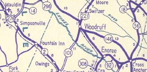
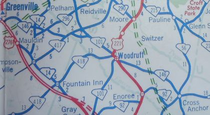
Creation: SC 146 appeared in 1942 as new primary routing, running from US 221 Woodruff to SC 56 Cross Anchor. This is the only SC 146.
Adjustments: In 1958, SC 146 was extended north with US 221, then northeast with SC 101, then west with SC 417, then replaced S-23-163, then west with SC 296, then replaced S-23-49 and S-23-145 to end at US 276 Greenville.
In 1959, SC 146 was given its current routing between SC 101 and SC 417 instead of going to Cashville.
About 1960, SC 146 was moved to accommodate the I-26 interchange, leaving behind S-42-87 and also "Old Hwy 146". Also around this time, SC 146 was removed from Buncombe Rd just north of SC 56.
Improvements: SC 146 was paved upon designation
By the late 1980s, SC 146 was multilane from S-23-183 Roper Mtn Rd to I-385; also through Woodruff
In 2006, SC 146 was multilaned on its SC 101 overlay.
In 2008, SC 146 was multilaned from US 276 to Roper Mtn Rd; also from I-385 to SC 296
Comment: SC 146 can serve as a useful route between I-26 and the Greenville-Spartanburg Airport (via SC 101).
SC 146 out of Woodruff
1942 Official
|

SC 146 extended to Greenville
1958 Official
|
SC 146 cuts off between SC 101-417
1959 Official
|
|