ROUTE LOG
SC 174: 0 - 0
SC 164: 2.3 - 2.3
SC 165: 4.4 - 6.7
US 17: 6.8 - 13.5
|
|
Creation: SC 162 appeared in 1942 as new primary routing (although this had been US 17 a few years prior), running as it does today, plus extended west to Parkers Ferry and then north to today's Greenwood Rd just past Bull Bridge Creek. This is the only SC 162.
Adjustments: In 1947, SC 162 was truncated to end at US 17 Osborn, concurrent with SC 174. The old route west became S-10-40, a bit of US 17, and S-10-38.
Between 1953-57, SC 162 was removed from its SC 174 overlay.
Improvements: SC 162 was paved upon inception except north of Parkers Ferry; no multilane segments
Comment: SC 162 is also the routing of today's SC 6 when it used to run from Charleston to Walterboro.

SC 162 in western Charleston County
1942 Official
|
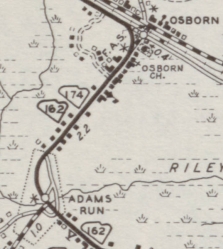
SC 162 truncated
1947 Official
|
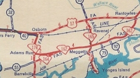
SC 162 duplex with SC 174 for a time
1952 Charleston County
|
|