Previous SC 169's:
1946 ROUTE LOG
SC 170: 0 - 0
SC 169 ALT: 4.4 - 4.4
END SC 169: 2.2 - 6.6
|
|
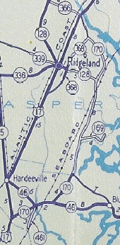
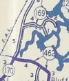
SC 169: Appeared in 1940 as new primary routing, running from SC 170 (now SC 462) east to today's S-7-27.
In 1942, SC 169 was extended east as new primary routing 2 more miles to the confluence of Chechessee Creek and Chechessee River.
In 1946, SC 169 was downgraded to S-7-18 and S-7-27. Today it is mostly SC 170 except for where the road loops south and around (and is still S-7-18) and SC 169 used Echotango Rd south of the SC 170 bridge over the Chechessee. Note that today's S-7-27 was SC 169 ALT.
SC 169 appears
1940 Official
|
SC 169 extended east
1942 Official
|
|