ROUTE LOG
SC 124: 0 - 0
US 25: 0.5 - 0.5
SC 183: 1.9 - 2.4
US 276, BEGIN SC 291: 2.3 - 4.7
SC 291 SB: 0.2 - 4.9
SC 290 EB: 8.7 - 13.6
SC 290 WB: 0.2 - 13.8
SC 414: 5.5 - 19.3
|
|
Creation: SC 253 appeared in 1939 as new primary routing, running from US 25-276 in north Greenville in a loop north around Paris Mountain State Park and ending at US 25 (now US 25 CONN Poinsett Hwy) Travelers Rest. This is the only SC 253.
Adjustments: In 1947, SC 253 was downgraded to S-23-22. It is unclear whether SC 253 only used the now-incomplete loop of S-23-169 Tanyard Rd plus Old Tanyard Rd.
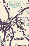
In 1950, SC 253 returned, running from US 25-276 North Greenville to SC 414 Tigerville.
Between 1958-63, SC 253 was removed from Camp Crrek Rd and Camp Creek Rd Ext just south of Tigerville.
In 1965, SC 253 south was extended as new primary routing (likely new construction) to SC 250 (now US 25).
In 1968 or 1969, SC 253 south was extended over S-23-105 to end at SC 124.
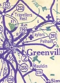
SC 253 appears north of Greenville
1939 Official
|
SC 253 decommissioned
1948 Official
|
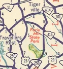
SC 253 returns but now to Tigerville
1950 Official
|

SC 253 extended to SC 250
1950 Official
|

SC 253 extended to SC 124
1950 Official
|
Improvements: SC 253 was fully paved in 1942.
SC 253 was multilaned on its SC 291 duplex in 1966 or 1967.
SC 253 was multilaned a short distance south of US 276 in 1975.
SC 253 was multilaned south from US 276 to US 25 in 2007 or 2008.
Comment: SC 253 still serves as the way to get to Paris Mountain State Park.
|