ROUTE LOG
SC 4: 0 - 0
US 321 NB, SC 400: 7.6 - 7.6
US 321 SB: 0.3 - 7.9
SC 70: 7.1 - 15.0
US 301, US 601: 3.0 - 18.0
|
|
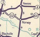
Creation: SC 332 appeared about 1929 as new primary routing, running from SC 6 (now US 321-SC 332-400 jct) Norway to SC 33 (now US 301-601) Cope. This is the only SC 332.
Adjustments: In 1940, SC 332 was extended west as new primary routing to SC 4 near Springfield.
In 1942, SC 332 east was extended as new primary routing to end at SC 36 (now S-38-39).
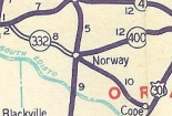
In 1947, SC 332 east was truncated to SC 5-400 Norway, leaving behind S-38-20 from Norway to Cope and S-38-44 (now S-38-63) east of Cope.
In 1949, SC 332 was re-extended to US 301 Cope. One section had not been SC 332 before in the Roberts Swamp/SC 70 area: Wayne Rd and a bit of modern SC 70 were bypassed.
SC 332 also used to use S-38-20 St. Johns Ave and a bit of SC 400. SC 332 may have been put on its current Norwy routing in 1949 but county maps do not explicitly and definitively show it until 1963.
Improvements: Paved from Norway to Cope in 1949.
SC 4 to Norway was paved in 1950
No multilane sections
Comment: SC 332's western half is a nicely aligned route that can be used along with SC 400 as an alternate to SC 4.
|
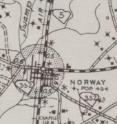
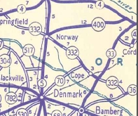
SC 332 using St. Johns Ave and SC 400 in Norway
1940 Orangeburg County
|
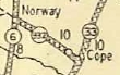
SC 332 Norway to Cope
1930 Official
|
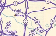
SC 332 extended to SC 4
1940 Official
|
SC 332 extended to SC 36
1942 Official
|
SC 332 truncated to Norway
1948 Official
|
SC 332 re-extended to Cope
1949 Official
|
|