< SC 524 | Home | SC 526 >
| SC 525 not currently assigned | ||||||
| Previous SC 525's: 1946 ROUTE LOG US 17, US 701: 0 - 0 SC ?: 3.9 - 3.9 US 52, US 78, SC 2: 6.3 - 10.2 END SC 525: 1.0 - 11.2 |
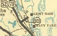
SC 525: Appeared in Sept 1937 (SCDOT) as new primary routing running from US 52-78 North Charleston along Remount Rd east to Virginia Ace near what was then an Army Depot.
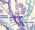
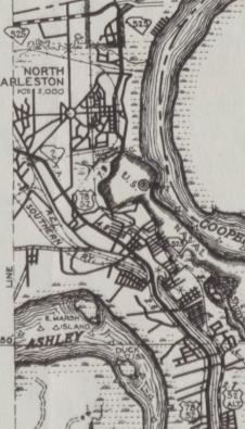
In 1940, SC 525 was extended west as new primary routing to the airport. The ending was 0.2 miles west of current Aviation Ave, with the last 0.1 mile not a road anymore and covred by airport runway. Also in 1940, SC 525 was extended south along Virginia Ave (now S-10-58), then Ave B on the old Naval Shipyard Base, then across (bridge gone now) Noisette Creek onto Ave D which has a fence blocking its continuance as St. Johns Ave. SC 525 followed St. Johns Ave (mostly still original concrete between the O'Hear Ave intersections) then east on Macmillan St, then south on Kephart St/North Carolina Ave (S-10-1026), south on Spruill Ave, then west on Clement Ave (S-10-22) to end at US 52 ALT (now US 52). In 1943 (bridge date), SC 525 was rerouted to leave Remount Rd on N. Rhett Ave, then south to Park Circle, then either Buist or Montague east to Spruill Ave all the way south to Meeting St, then replaced US 52 ALT to end at Meeting and Lee (then-US 17-701). Clement Ave likely remained in the primary system but whose number is not known (SC 525 ALT?). In 1947, SC 525 was downgraded to S-10-27 (now S-10-13) west of US 52-78; S-10-13 on Remount east of US 52-78; S-10-22 on N. Rhett Ave (now S-10-60); either S-10-62 Montague or S-10-59 Buist; S-10-32 on Spruill Ave. Meeting St became part of US 52.
| |||||

Previous: SC 524 |
Next: SC 526
Top | South Carolina Hwy Index
Home
Page last modified 14 May 2015