< SC 752 | Home | SC 760 ALT | SC 761 >
|
|
|
| ROUTE LOG |
US 76, US 378: 0 - 0 I-77 (exit 10): 1.1 - 1.1 Ft. Jackson Gate: 0.1 - 1.2
|
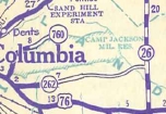
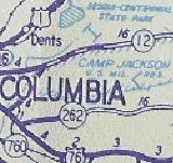
Creation: SC 760 appeared in 1939. Originally ran from US 76 Columbia into Fort Jackson, then east along the northern boundary of the Army Post at that time for a total of 8 miles, ending in the vicintiy of the Dixie Rd bridge over Rose Creek within Fort Jackson. This is the only SC 760.
| Adjustments: In 1940, SC 760 east was truncated to the current Jackson Blvd/Forest Rd/Dixie Rd intersection within Fort Jackson at SC 12. From here eastward SC 760 was replaced by SC 12 (now Dixie Rd). In 1941 (bridge date over Gills Cr), SC 760 was moved from Wildcat Rd to Fort Jackson Blvd. Wildcat Rd was shown as still primary (but unlabeled) on the 1942 Richland County map and my guess is that this was SC 760 ALT. Today it is US 76 CONN. Between 1943-48, SC 760 was removed from S-40-501 Oxford Rd. In 1953, SC 760 east was truncated to its current endpoint as Fort Jackson expanded its footprint, leaving behind Jackson Blvd.
Improvements: Fully paved since 1940; multilane since 1941. Comment: SC 760 is Fort Jackson Blvd, a main thoroughfare to reach the Army post. | |||||||
Previous: SC 752 |
Next: SC 760 ALT | SC 761
Top | South Carolina Hwy Index
Home
Page last modified 17 April 2015