< 810 to 819 | Home | 900 to 909 >
| SC 820 not currently assigned | |||||||||||||
| Previous SC 820's: |
SC 820: Appeared in 1941 or 1942 as new primary routing. Ran from SC 13-135 (current SC 93-135 jct) Easley southeast 4 miles to the Anderson County Line.
In 1948, SC 820 was downgraded to S-39-29. | 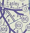 |
|||||||||||
| SC 821 not currently assigned | |||||||||||||
| Previous SC 821's: |
SC 821: Appeared by 1932 as a new primary route. Ran as a short stub off SC 82 (current SC 81) to the village of Bordeaux in McCormick County.
In 1940, SC 821 was extended south to SC 43 (current US 378) to its full length of 7 miles. In 1948, SC 821 was downgraded to S-35-7. | 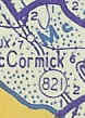 |
|||||||||||
| SC 822 not currently assigned | |||||||||||||
| Previous SC 822's: |
SC 822: Appeared by 1938 as a new primary route. Was a very short stub off SC 82 (curent SC 81) Lowdnesville.
In 1948, SC 822 was downgraded to (I think) S-1-65. |  |
|||||||||||
|
|
|
| ROUTE LOG |
SC 81: 0 - 0 Abbeville-McCormick Line: 5.6 - 5.6 SC 72: 5.7 - 11.3
|
Creation: Appeared as a resurrected state route between 1951-52. Ran as it does today.
| Adjustments: SC 823 originally appeared as new routing in 1940, running just like it does today, only its endpoints were SC 82 and SC 7. SC 823 was completely downgraded in 1948. Improvements: SC 823 was fully paved when it was resurrected. It has not been widened anywhere. Comment: Runs along the west edge of Sumter National Forest 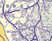 |
||||||

| SC 824 not currently assigned | |||
| Previous SC 824's: |
SC 824: Appeared as new primary routing in 1940. Ran from SC 82 (current SC 81) 1 mile west to Barnes in Southern Anderson County.
It appears that in 1941 or 1942, SC 824 was extended west another mile to the Abbeville County Line. In 1948, SC 824 was downgraded to S-4-36. |  |
|
| SC 831 not currently assigned | |||
| Previous SC 831's: |
SC 831: Appeared in 1940 as new primary routing, running from SC 83 Clio east 6 miles to SC 95 (current SC 57) near the Little Pee Dee River bridge.
In 1948, SC 831 was downgraded to S-34-19 and S-17-26. | 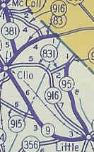 |
|
| SC 850 not currently assigned | |||
| Previous SC 850's: |
SC 850: Appeared in 1940 as new primary routing. Ran from SC 85 (current SC 145) north of Chesterfield to the North Carolina State Line.
In 1942 SC 850 was renumbered to SC 742 to match NC 742 which was extended south from Wadesboro. See scan under SC 851. | 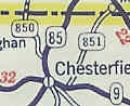 |
|
| SC 851 not currently assigned | |||
| Previous SC 851's: |
SC 851: Appeared in 1940 as new primary routing. Ran from SC 9 east of Chesterfield northeast to North Carolina, 7 miles away. North Carolina's side was SR 1837 Chesterfield Rd.
SC 851 was downgraded in 1948 to S-13-23. | 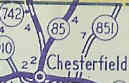 |
|
Last Update: 11 December 2004
Previous: SC 810 - 819 |
Next: SC 900 - 909
Top | South Carolina Hwy Index
Home