< TN 12 | Home | TN 13 Spur | TN 14 >
|
|
|
|
| ROUTE LOG |
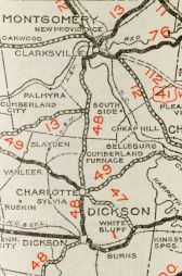
AL STATE LINE: 0 - 0 TN 227 EB: 2.3 - 2.3 TN 227 WB: 0.4 - 2.7 Natchez Trace Pkwy: 7.4 - 10.1 TN 203: 2.1 - 12.2 US 64, TN 15: 15.1 - 27.3 TN 228: 7.5 - 34.8 TN 48: 5.6 - 40.4 Perry-Wayne Line: 3.1 - 43.5 TN 128: 8.4 - 51.9 US 412, TN 20: 4.1 - 56.0 TN 438 EB: 6.7 - 62.7 TN 438 WB: 2.4 - 65.1 Humphreys-Perry Line: 8.8 - 73.9 I-40 (exit 143): 3.4 - 77.3 TN 230: 12.0 - 89.3 TN 13 Spur: 3.8 - 93.1 Houston-Humphreys Line: 12.2 - 105.3 TN 231: 3.8 - 109.1 TN 49: 3.0 - 112.1 TN 46: 4.4 - 116.5 Montgomery-Houston Line: 2.5 - 119.0 TN 235: 9.2 - 128.3 TN 48 SB: 2.1 - 130.3 TN 149: 5.6 - 135.9 US 41 ALT Byp SB, TN 12 EB, TN 76 EB: 2.6 - 138.5 TN 48 NB: 1.5 - 140.0 US 41 ALT, US 41 ALT Byp END, US 79 SB, TN 12 WB, TN 76 WB, TN 112: 0.8 - 140.8 TN 48 SB: 1.7 - 142.5 TN 48 NB: 2.2 - 144.7 TN 374: 0.8 - 145.5 I-24 (exit 4): 2.2 - 147.7 KY STATE LINE: 5.4 - 153.1
|
Creation: Appeared in 1923 as an original state highway, running from TN 1 (now TN 13 Spur) Waverly north through Erin and Clarksville to Kentucky at Guthrie.
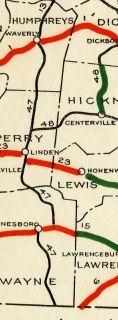
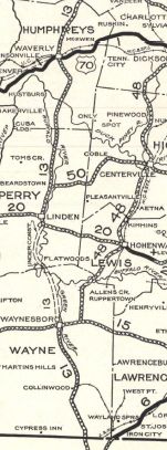
| Adjustments: It appears TN 13 originally used the current TN 149 corridor between Erin and Clarksville. This was changed by 1926 to avoid Stewart County entirely. It appears the old route used these surviving segments: a bit of TN 149 out of Erin; Substation Loop and Pitt Loop above Erin; most of TN 149 to Dolomite; a bit of Old TN 149 then TN 233 and TN 434; TN 149 from Cumberland City to Sailor Creek except right at the Guice Creek area. In 1927 or 1928, TN 13 was extended south replacing TN 47 through Linden and Waynesboro to the Alabama line heading for Florence. It is unclear if TN 47 was moved or if it was TN 13 when moved from the routing via Topsy to Linden but the old route was TN 99, Topsy Rd, Hollow Rd, Big Opposum Creek Rd and Mayberry Rd.
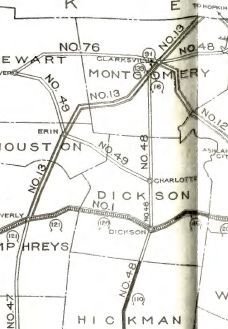
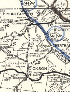
In 1931, TN 13 was moved from Franklin St (no longer crosses Red River)/Old Russellville Pike in Clarksville to College St. Also in 1931, TN 13 was removed from King Branch Rd/Dove Ln and Old Beardstown Rd at Beardstown In 1931 or 1932, TN 13 was rerouted again between Erin and Clarksville. The old routing is "Old Highway 13" in Houston/Montgomery Counties to TN 149; TN 149 eastward except: Fishermans Alley; Sheeks Cir; Killebrew Ln; Tarsus Church Rd; Hallibuton Cir; Harris Cir; a bit of Shiloh Canaan Rd; abandoned roadway; Patsy Rd and the lengthy Palmyra Rd to Hilltop.
In 1933, TN 13 was removed from Melrose Ave (no longer connects to)/Tank Hill Rd north out of Linden and also from Woolworth Loop in Woolworth In 1934, TN 13 was removed from Cherry St in Linden; Old Hwy 13 N out of Linden Also in 1934, AASHO tried to assign US 43 from Alabama to Waynesboro and from the north end of TN 48 to Clarksville. In 1937, AASHO tried to assign US 42 from Clarksville to Kentucky. It is unclear if TN 13 ever used any of these loops in Montgomery County but definitely stopped doing so by 1939: Carney Cir at Shiloh; Philip Rd at TN 235; Alonzo Pl and Morgan Cir at Cunningham; Yarbrough Cir and Ball Rd north of Cunningham In 1939, TN 13 was straightened out at the Buffalo River crossing north of Flatwoods, leaving behind Armstrong Rd (no longer connects to)/Old Mt Olive Rd In 1949, TN 13 was removed from Old Hwy 13 just inside Humphreys County; also from Keegan Ln/abandoned route/Cuba Landing Rd/Bodine Loop (cutoff by I-40)/Old Highway 13 through Buffalo and Hurricane Mills (still partly unpaved) up to nearly TN 230; also Old Linden Rd and Main St within Linden In 1952, TN 13 was removed from 4th Ave in Lobelville and Tennessee Gas Rd About 1960, TN 13 was removed from the lengthy Old Hwy 13 S through Bethel; S. Mill St/US 412 in Linden In 1965, TN 13-48 was removed from River Rd/Zinc Plant Rd to a new Cumberland River crossing approaching Clarksville. In the mid 1970s(?), TN 13 was placed on Riverside Dr around Clarksville. The old route through town used Cumberland Dr, Madison St, 2nd/3rd St one-way pair and College St. Posting: TN 13 is primary throughout except between Erin and TN 48 Cunningham, which is secondary. TN 13 is not posted south of Riverside Dr in Clarksville Secret US Route Overlay: US 79 (12.3 mi) Comment: TN 13 is a major N-S corridor in west central Tennessee | ||||||||
Previous: TN 12 |
Next: TN 13 Spur | TN 14
Top | Tennessee Hwy Index
Home
Page last modified 27 June 2021