< TN 52 | Home | TN 54 >
|
|
|
| ROUTE LOG |
US 41, TN 2: 0 - 0 I-24 (exit 110): 0.9 - 0.9 TN 280: 9.3 - 10.2 Cannon-Coffee Line: 0.9 - 11.1 TN 281: 8.8 - 19.9 US 70S WB, TN 1 WB: 4.4 - 24.3 US 70S EB, TN 1 EB: 0.7 - 25.0 Dekalb-Cannon Line: 11.1 - 36.1 US 70 EB, TN 26 EB, TN 96 NB: 3.7 - 39.8 TN 96 SB: 1.4 - 41.2 US 70 WB, TN 26 WB: 3.9 - 45.1 Smith-Dekalb Line: 1.5 - 46.6 TN 141 WB: 6.5 - 53.1 TN 141 EB, TN 264: 4.5 - 57.6 I-40 (exit 258): 0.4 - 58.0 US 70N WB, TN 24 WB: 4.2 - 62.2 TN 264: 4.0 - 66.2 US 70N EB, TN 53 EB: 3.7 - 69.9 Jackson-Smith Line: 4.2 - 74.1 TN 290: 4.5 - 79.6 TN 262: 7.8 - 87.4 TN 56 SB: 0.8 - 88.2 TN 56 NB, TN 85 WB, TN 135 NB: 1.2 - 89.4 TN 135 SB: 0.2 - 89.6 TN 85 EB: 0.6 - 90.2 Clay-Jackson Line: 9.2 - 99.4 TN 292: 1.8 - 100.2 TN 52: 5.7 - 105.9 KY STATE LINE: 8.9 - 114.8
|
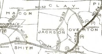
Creation: Appeared in 1923 as an original state highway, running from TN 24 (now 1st St) Baxter to TN 52 (now Old Livingston Hwy) Celina.
| Adjustments: In 1927 or 1928, TN 53 south was rerouted at Gainesboro to head southwest as new state highway to Chestnut Mound, then followed TN 24 west to S. Carthage, then south as more new state highway to Alexandria, then followed TN 26 southeast to near Liberty, then went south as new state highway to end at TN 1 Woodbury. The old route from Gainesboro to Double Springs became part of TN 56 (today this is TN 291; TN 56 to Gainesboro except - Old Gainesboro Rd in Bloomington Springs as well as Bethel Park Rd just inside Jackson County; Herbert Johnson Cir/Biss Johnson Cir, Lee Fox Cir, James Stafford Rd, Hubert Brown Cir and Pap Johnson Cir north of Center Grove. In 1929, TN 53 was extended from Celina east to TN 24 (now TN 111) west of Byrdstown. In 1931 or 1932, TN 53 was extended south to US 41/TN 55 (now Woodland at Fort St) Manchester.
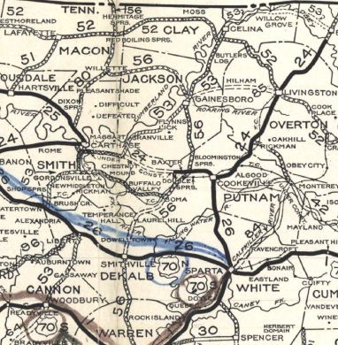
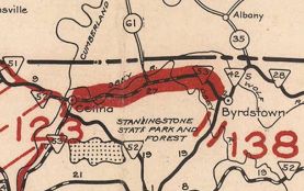
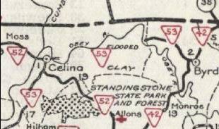
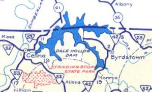
In 1932, TN 53 was given its current Cannon County routing north of Woodbury. It is unclear whether TN 53 used Doolitte Rd/Pleasant Ridge Rd or Cavender Rd prior to this. In 1934, TN 53 was removed from the lengthy Hollow Springs Rd in southern Cannon County. In 1935, TN 53 was removed from abandoned route/Dry Fork Rd/Flynns Creek Rd below Flynns Lick. This is also likely when TN 53 was removed from Jack Roberts Rd and Cabin Cir between there and Gainesboro. If TN 53 ever used Old Woodbury Hwy north of I-24 it stopped doing so by 1936. If TN 53 ever used Hayes St/Old Manchester Rd south out of Woodbury it stopped doing so by 1938. Between 1941-43, TN 53 was essentially closed east of Celina as Dale Hollow Lake was formed. The largest surviving piece, from then-TN 42 westward, explicitly remained in the highway system through at least 1949. Surviving segments are: Dale Hollow Marina Rd west of the lake; TN 294 starting at the entrance to the Willow Grove Recreation Area and heading east; Lily Dale Rd; TN 325 east of the lake In 1942, TN 53 was removed from Enigma Rd between Chestnut Mound through Enigma to abandoned (underwater) alignment at Little Indian Creek and the Jackson County line. In the 1940s, TN 53 was placed on its current routing through Granville. The original route used Clover St which used to meet current TN 53 near Huff Branch. In 1947, TN 53 was removed from Clear Fork Rd/Old Givens Hollow Rd south of Liberty. I'm guessing about 1950 TN 53-56 was removed from Murray St in Gainesboro, which used to connect to TN 53-56 at the north end of Birch St. In 1951, TN 53 was extended from Celina, replacing the short-lived TN 137 northeast to Kentucky near Thompsons Store.
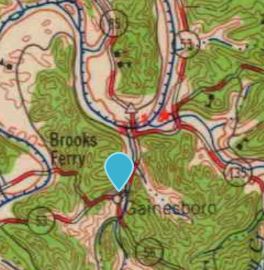
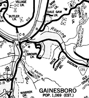
In 1953, TN 53 was placed on the current US 70 routing between Liberty and Alexandria. This left behind abandoned alignments west out of Liberty; "Old Hwy 53"; Driver Rd; Old Liberty Rd Sometime before 1961-77, TN 53 was removed from Cedar Point Cir and Main St into South Carthage. Sometime between 1961-79, TN 53 was removed from Pelham Rd and abandoned routing south of Woodbury. In 1972, TN 56-85 was rerouted east out of Gainesboro to its current Roaring River crossing. The old route became more TN 135 and abnadoned routing through Roaring Creek Park to the former bridge crossing.
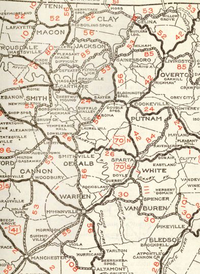
In 1975, TN 53 was removed from Mitchell St and E Lake Ave through Celina. In 1978, TN 53 was removed from Old State Route 53/Sugar Creek Rd well north of Gainesboro; around this time TN 53 was also removed from the gnarly Old Highway 53 just inside Clay County. In 1981, TN 53 was removed from Brush Creek Circle through Brush Creek; Paschall Cir; Cherry Cir; Scudder Rd in New Middleton In 1985, TN 53 was given its bypass of Alexandria, leaving behind High St and Edgewood Dr. Between 1990-93, TN 53 was given its current Corridor J routing northeast of Celina, leaving behind: East Old Hwy 53; Lake View Dr; abandoned routing across modern TN 53; Schell Ln; West Old Hwy 53; Davistown Loop; Stephens Cir; Fire Hall Rd through Thompsons Store and to the Kentucky Line. Posting: Posted as primary routing Manchester to South Carthage and Gainesboro to Kentucky; posted as secondary everywhere else. The US 70S overlay is fully posted; the US 70 overlay is not. The US 70N overlay is posted only at the western split Secret US Route Overlay: None Comment: TN 53 from Celina to Kentucky is part of ADHS Corridor J | |||||||||||||
Previous: TN 52 |
Next: TN 54
Top | Tennessee Hwy Index
Home
Page last modified 31 December 2020