< TN 94 | Home | TN 95 Temp | TN 96 >
|
|
|
| ROUTE LOG |
US 411, TN 33: 0 - 0 US 321 NB, TN 73 EB: 9.9 - 9.9 TN 444: 3.6 - 13.5 US 11, TN 2: 1.9 - 15.4 I-75 (exit 81): 2.6 - 18.0 US 70, TN 1: 0.9 - 18.9 I-40 (exit 364), US 321 END, TN 73 END: 3.8 - 22.7 Roane-Loudon Line: 0.9 - 23.6 TN 58: 5.8 - 29.4 Anderson-Roane Line: 4.4 - 33.8 TN 62: 3.2 - 36.0 TN 61: 5.5 - 41.5
|
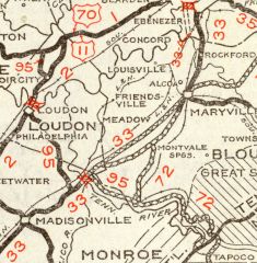
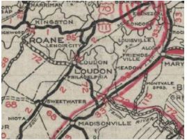
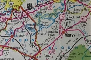
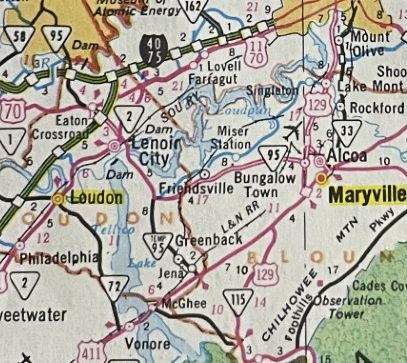
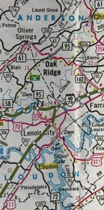
Creation: Appeared in 1927 or 1928 running from US 70 Eatons Crossroads south through Lenoir City to Loudon, then south to end at TN 33 (now US 411) Vonore.
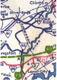
| Adjustments: In 1929, TN 95 was extended from Vonore across the Little tennessee River, then extended east to end at TN 72 (now US 129) Bacon's Ferry. In 1933 or 1934, TN 95 south was truncated to US 11 Lenoir City. Lenoir City to Loudon remained part of US 11, while the route to Lenore became part of TN 72 (today this is Grove St leaving Loudon; Vonore and Old Vonore Hwys and a litle bit of Chop Way; the old route is underwater to Monroe County except a tiny Old Vonore Hwy near current TN 72; pieces of Rarity Bay Pkwy; underwater some more; Church St in Vonore; US 411 across the river; Clearview Dr, underwater, Marina Harbor; TN 72 to Hammantree Branch; abandoned routing to Smoky Branch; "Old Hwy 72" in 3 disconnected (and possibly not publicly accessible) segments along waterways to TN 72 near the US 129 junction. In 1951, TN 95 was extended north as new routing to the Clinch River at White Wing Ferry In 1957 or 1958, TN 95 was extended across a new bridge over the Clinch River then cut northeast to end at TN 61 southwest of Clinton.
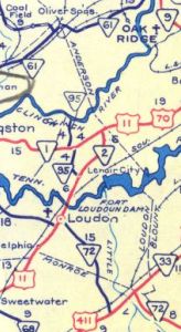
In 1962, TN 95 was removed from Kingston St/Old TN 95 north out of Lenoir City; US 70 and placed on today's US 321 routing. Between 1963-64, TN 95 was extended south across the Fort Loudon Dam and down to US 411 Greenback. It is unclear if this happened initially but by 1971 the route south of Lenoir City was designated as TEMP TN 95 In the late 1970s, TN 95 was removed from Elza Dr near TN 61 In 1980, TN 95 was extended east from near the Fort Loudon Dam to Maryville on newly constructed routing and US 321 was added to TN 95 from Maryville to I-40. The 1980 and 1981 Officials show TN 95 doing this and TN 95 TEMP still in place. In 1982, TN 95 was removed from US 321 out of Maryville (replaced by TN 73) and again sent south replacing TN 95 TEMP to end once again at US 411 Greenback. TN 73 was also added to TN 95 all the way to I-40. About 1984, TN 95 was removed from White Wing Rd and straightened out east of I-40
Posting: Posted as primary from I-40 to Clinton; secondary US 411 to US 321 The overlay with US 321 is not posted Secret US Route Overlay: None (the secret route with US 321 is TN 73) Comment: TN 95 is the E-W major thoroughfare through Oak Ridge TN 95 is misidentified as TN 85 on the 1929 official. | ||||||||||||