ROUTE LOG
US 70, TN 1: 0 - 0
TN 47: 2.1 - 2.1
Williamson-Dickson Line: 8.1 - 10.2
I-40 (exit 182): 0.5 - 10.7
TN 100 WB: 5.0 - 15.7
Davidson-Williamson Line: 4.4 - 20.1
TN 100 EB: 0.9 - 21.0
Williamson-Davidson Line: 1.7 - 22.7
Natchez Trace Parkway: 1.6 - 24.3
TN 46: 3.6 - 27.9
US 431 Bus NB, TN 106 NB: 4.9 - 32.8
US 31 Bus, TN 6: 0.1 - 32.9
US 431 Bus SB, TN 106 SB: 0.1 - 33.0
US 31, US 431, TN 397: 1.5 - 34.5
I-65 (exit 65): 1.1 - 35.6
TN 252: 7.4 - 43.0
US 31 ALT, US 41 ALT, TN 11: 3.1 - 46.1
Rutherford-Williamson Line: 3.4 - 49.5
TN 102: 0.8 - 50.3
I-24 (exit 78): 8.5 - 58.8
TN 99 WB: 1.6 - 60.4
US 41, US 70S, US 231 SB, TN 1, TN 10 SB, TN 99 EB: 0.6 - 61.0
US 231 NB, TN 10 NB: 1.0 - 62.0
TN 268: 5.2 - 67.2
TN 266 WB: 2.9 - 70.1
TN 266 EB: 0.9 - 71.0
Cannon-Rutherford Line: 6.8 - 77.8
TN 145: 3.8 - 81.6
Wilson-Cannon Line: 1.2 - 82.8
TN 267: 0.9 - 83.7
DeKalb-Wilson Line: 3.2 - 86.9
US 70 WB, TN 26 WB, TN 53 SB: 1.7 - 88.6
TN 53 SB: 1.4 - 90.0
US 70 EB, TN 96 EB: 5.4 - 95.4
TN 264: 4.8 - 100.2
TN 141 WB: 6.0 - 106.2
TN 141 EB: 1.1 - 107.3
Putnam-Dekalb Line: 2.3 - 109.6
I-40 (exit 268): 1.4 - 111.0
Smith-Putnam Line: 3.0 - 114.0
Putnam-Smith Line: 0.5 - 114.5
US 70N WB, TN 24 WB: 0.1 - 114.6
US 70N EB: 4.8 - 119.4
Jackson-Putnam Line: 6.5 - 125.9
TN 53: 2.2 - 128.1
|
|
Creation: Appeared in 1927 or 1928 running from US 31 Franklin east through Murfreesboro to US 70 near Liberty.
Adjustments: By 1932, TN 96 west may have been extended to TN 106 (now TN 46) Bethlehem. This had been US 31/TN 6 up until 1929.
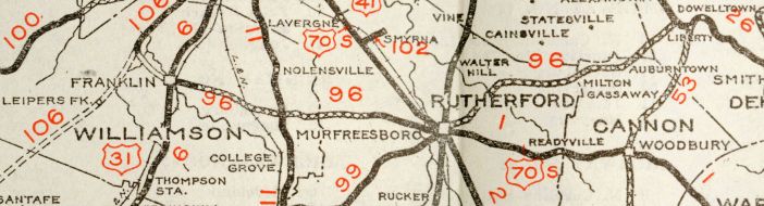
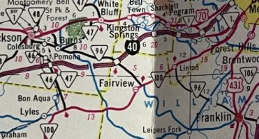
TN 96 from TN 106 or Franklin to Liberty
1932 Official
If TN 96 ever went directly through the courthouse square in Murfreesboro it stopped doing so by 1939.
In 1939 or 1940, TN 96 west definitely ended in Franklin.
In 1949 or 1950, TN 96 west was extended west through Leipers Fork to end at TN 47 Burns
In 1956, TN 96 was straightened out from Burns to Williamson County, leaving behind abandoned route north and west of Beaverdam Cr; Spencer Mill Rd/Eastside Rd through Eastside; Old eastside Rd/Old White Bluff Rd/abandoned routing;
Also in 1956, TN 96 was removed from Old State Hwy 96 in Wilson County; Cottage Home Rd
In 1957, TN 96 was removed from Northwest Hwy from TN 100 west to New Hope plus New Hope Rd and placed on new construction.
About 1962, TN 96 west was rerouted at Burns and extended as new construction to US 70 in eastern Dickson. This left behind Church St in Burns.
About 1963, the modern TN 96 routing from Franklin to TN 46 was completed. It is unclear if TN 96 was temporarily sent southwest on TN 46 back to Leipers Fork. The 1971 Official suggests no.
It appears about 1966 that TN 96 was rerouted in Murfreesboro to follow US 231 to East Clark Blvd to Lascassas Pike. The old route used E. Main St, Middle Tennessee Blvd, Greenland Dr and Old Lascassas Pike
It appears that about 1970, TN 96 was removed from Old Highway 96 and today's TN 266 in Lascassas; Milton St in Milton and Old Milton Rd in Rutherford County.
In 1971, the rest of new TN 96 was constructed from TN 46 to TN 100 in Davidson County and TN 96 was put on it. This left behind today's TN 246 to Southall; Southall Rd to Leipers Fork; "Old Hwy 96" to Fernvale; Ferndale Rd and Old Nashville Rd to Fairview
In 1973, TN 96 was placed on its modern Murfreesboro routing of Old Fort Pkwy, Memorial Blvd and E. Clark blvd. The old route used Bridge Ave, W. Main St, N Front St, College St, N. Maple St.
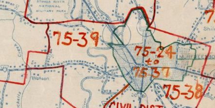
TN 96 original Murfreesboro route
1939 Rutherford County
|
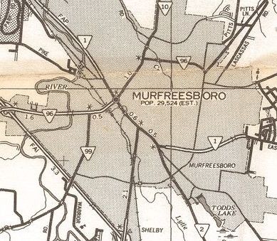
TN 96 modern Murfreesboro route
1977 Rutherford County
|
In 1979, TN 96 was removed from Old Milton Hill Rd in Cannon County; W. Main St/TN 145 in Auburntown
In 1981, TN 96 was removed from Old Highway 96 just west of I-40 exit 182.
In 1982, TN 96 east end was moved 0.2 miles west on US 70, leaving behind "Old hwy 96"
In 1983, TN 96 east was extended with US 70 through Dowelltown, then extended north to US 70N, then east with US 70N, then north to end at TN 53 Granville.
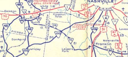
TN 96 west extended to Burns
1951 Official
|
TN 96 west extended to Dickson and routed away from Leipers Fork
1972 Official
|
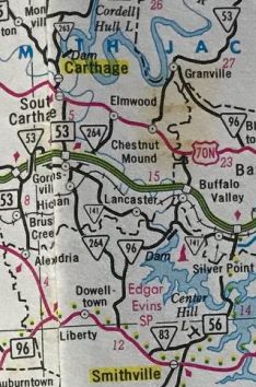
TN 96 east/north extended to Granville
1986 Official
|
Between 2001-07, TN 96 was rerouted in Franklin to use Church St to get from 5th Av to 3rd Ave instead of US 31 Bus Main St.
Posting: Posted as primary from Dickson to Liberty; secondary Liberty to Granville
The overlays with TN 100, US 431 Bus and US 231 are posted
The overlays with US 70 and US 70N are not posted.
TN 96 changes from E-W to N-S at US 70 Liberty.
Secret US Route Overlay: None
Comment: TN 96 is blown off by I-840 but can easily reach it via either TN 102 or US 41A.
The Natchez Trace Parkway overpass is sleek and spectacular.
Prior to TN/I-840 TN 96 was the way to go from Franklin to Murfreesboro.
TN 96 crosses Center Hill dam and serves the nearby Edgar Evins State Park.
North of US 70 TN 96 is full of winding alignments
|