< US 78 | Home | US 79 Byp | US 111 >
| ROUTE LOG AR STATE LINE: 0 - 0 I-55 SB (exit 12), TN 1 Begin: 0.5 - 0.5 US 61 SB, TN 14: 0.7 - 1.2 US 78 EB, TN 4: 0.4 - 1.6 TN 278: 0.9 - 2.5 US 51 NB, TN 1 NB, TN 3 NB: 0.3 - 2.8 I-240 (exit 30): 1.3 - 4.1 US 51 SB, US 72 Begin, TN 3 SB, TN 23 Begin: 0.2 - 4.3 US 72 EB, TN 23 EB, 277 SB: 2.1 - 6.4 TN 57 EB, TN 277 END: 0.5 - 6.9 TN 1 WB, TN 57 WB: 0.7 - 7.6 I-40 (exit 10): 5.4 - 13.0 US 64 EB, TN 15: 4.7 - 17.7 TN 177: 3.3 - 21.0 TN 385: 7.2 - 28.2 Fayette-Shelby Line: 3.6 - 31.8 TN 196: 1.7 - 33.5 TN 59 EB: 4.1 - 37.6 Tipton-Fayette Line: 2.1 - 39.7 TN 59 WB: 0.9 - 40.6 Haywood-Tipton Line: 3.9 - 44.5 TN 222: 4.2 - 48.7 TN 179: 0.1 - 48.8 TN 19 WB: 10.7 - 59.5 TN 76 SB: 2.2 - 61.7 TN 19 EB: 0.8 - 62.5 US 70 EB, US 70 ALT Begin, TN 1 EB: 0.5 - 63.0 TN 369: 1.2 - 64.2 Crockett-Haywood Line: 10.1 - 74.3 TN 88 WB: 1.0 - 75.3 TN 88 EB: 0.2 - 75.5 US 412, TN 20: 1.5 - 77.0 TN 221: 5.4 - 82.4 Gibson-Crockett Line: 4.1 - 86.5 US 70 ALT Byp, US 79 Byp, TN 366: 0.3 - 86.8 US 45W NB, TN 5 NB: 1.0 - 87.8 US 45W SB, TN 5 SB: 0.5 - 88.3 TN 152: 0.3 - 88.6 US 45W Byp, US 70 ALT Byp, US 79 Byp, TN 366: 1.1 - 89.7 TN 187: 1.8 - 91.5 TN 186: 2.2 - 93.7 US 45E, TN 43, TN 77 WB, TN 104: 5.9 - 99.6 TN 425: 1.9 - 102.5 TN 77 EB: 2.3 - 104.8 Carroll-Gibson Line: 0.2 - 105.0 TN 220: 1.6 - 106.6 US 70 ALT EB, TN 77 EB: 1.6 - 108.2 TN 220 ALT: 0.6 - 108.8 TN 77 WB: 0.6 - 109.4 TN 105: 3.6 - 113.0 TN 436: 9.7 - 122.7 TN 124: 0.5 - 123.2 TN 423: 0.4 - 123.6 TN 22: 1.1 - 124.7 Henry-Carroll Line: 1.1 - 125.8 TN 218: 11.8 - 137.6 US 641, TN 69: 1.4 - 139.0 TN 356: 0.9 - 139.9 TN 218 SB: 3.3 - 143.2 TN 218 NB: 3.0 - 146.2 TN 140: 7.1 - 153.3 TN 119: 2.6 - 155.9 Stewart-Henry Line: 1.5 - 157.4 TN 232: 4.4 - 161.8 TN 461: 5.8 - 167.6 TN 49: 3.0 - 170.6 TN 120: 8.9 - 179.5 TN 46: 3.5 - 183.0 Montgomery-Stewart Line: 2.3 - 185.3 TN 233: 5.5 - 190.8 TN 374: 4.0 - 194.8 US 41 ALT NB, TN 12 NB: 3.9 - 198.7 US 41 ALT SB, US 41 ALT Byp, TN 13 SB, TN 76 EB, TN 112: 1.5 - 200.2 TN 48 SB: 1.7 - 201.9 TN 48 NB: 2.2 - 204.1 TN 374: 0.8 - 204.9 I-24 (exit 4): 2.2 - 207.1 KY STATE LINE: 5.4 - 212.5 |
Creation: US 79 was not an original US route but its original 1935 run had its northern end in Memphis. It is not clear where it ended or even if it was posted in Tennessee. US 79 was extended east with US 70 into Memphis from Arkansas.
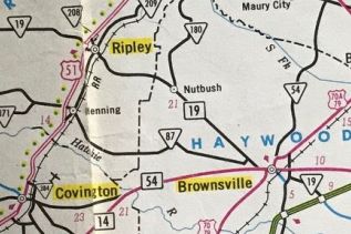
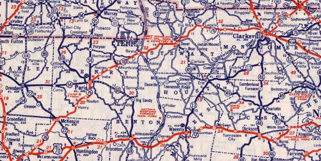
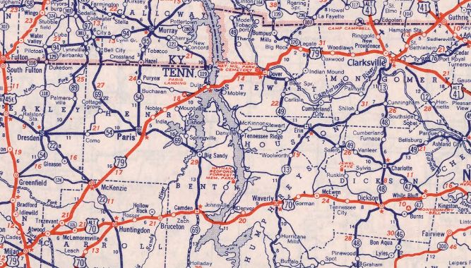
Adjustments: In 1944, US 79 was extended east with US 70 to Brownsville; northeast with TN 76 through Humboldt, Milan, and McKenzie to Clarksville; then followed TN 76 to Kentucky.
 TN 76 across northern tier 1944 Rand McN
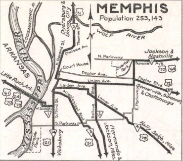
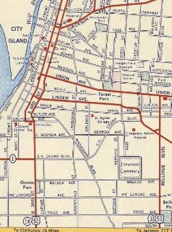
 US 79 across northern tier 1948 Rand McN By 1947, US 79 moved from 2nd St to 3rd St in Downtown Memphis.
About 1948, US 79 was given its direct routing through Milan. Prior to this it used Highland St, College St, Main St, Williamson St and Park Ave.
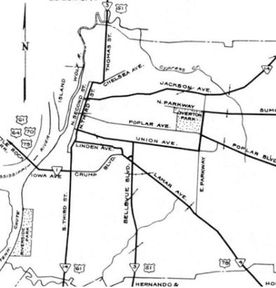
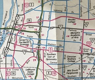
In 1949, US 79 was placed on the new Memphis-Arkansas bridge, leaving behind the Hanaran Bridge which is still open to foot/bicycle traffic. In 1951, US 79 was removed from Main St, Paris Ave and Paris Pike in McKenzie. By 1953, US 79 was put on one way splits through downtown Clarksville - WB used 3rd/College and EB used the original routing of 2nd/Madison. Between 1952-56, US 79 was put on one-way routing through downtown Memphis, with EB using 3rd and WB using 2nd/Calhoun. In 1957, US 79 was removed from Harmony Church/Old harmony Church Rds at the Montgomery-Robertson line which used to connect back to TN 76 at about S. Bryant Rd. The former Sulphur Fork Bridge is still standing. In 1958, US 79 was removed from the lengthy Old Hwy 79 from east of Dover to TN 120. It appears US 79 was placed on its modern route from the Tennessee River to west of Dover in a couple stages in the early 1970s. The original route used Old Paris Landing Rd; Walnut Grove Rd; Onion Hill Rd; Pumpkin Ridge Rd/Gentry Cir; Buckner Rd About 1983, US 79 was routed around Downtown Memphis using Danny Thomas from Union to Crump. The old routing on Union remained TN 3 and 2nd/3rd remained TN 14.
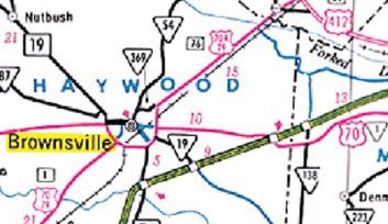
In 1984, US 79 was removed from Church St in Dover. In 1995, US 79 was placed on its bypass around the south and east of Brownsville, leaving behind Grand Ave; TN 54 on Main St west of the square; TN 54 on Washington St north of the square; all of TN 369.
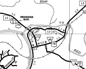
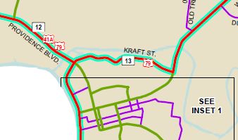
About 2003, US 79 was removed from Pioneer Rd through Henry and Camp Tyson Rd through Routon About 2006, US 79 was removed from Dover Rd through Oakwood Between 2006-08, US 79 was rerouted in Clarksville to use TN 13 Kraft St. The old routing used US 41A 2nd St and TN 48 College St.
In 2008, US 79 was removed from Woodlawn Rd west of Clarksville In November 2024, US 79 was moved to the partly completed Atwood Bypass, then west with TN 77 back into town to the original route. It appears the old route is still TN 77. Posting: Fully posted but poorly posted in Downtown Memphis. The turns involving Danny Thomas are unmarked in all directions. Secret TN Route Overlay: TN 1 I (2.3 mi) TN 3 (1.5 mi) TN 23 (2.1 mi) TN 277 (0.5 mi) TN 57 (0.7 mi) TN 1 II (10.1 mi) TN 76 (180.1 mi) TN 13 (12.3 mi) Comment: US 79 connects Clarksville to points southwest towards Memphis. | ||||||||||