< I-81 | Home | I-66 >
|
|
|
|
| ROUTE LOG |
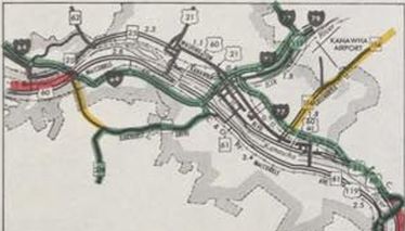
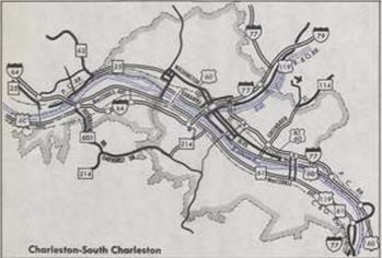
Kentucky State Line: 0 - 0 EXIT 1 - US 52 SB, WV 75: 1.3 - 1.3 Cabell-Wayne Line: 4.6 - 5.9 EXIT 6 - US 52: 0.6 - 6.5 EXIT 8 - WV 152, WV 527: 1.7 - 8.2 EXIT 11 - WV 10: 2.8 - 11.0 EXIT 15 - US 60: 3.6 - 14.6 EXIT 18 - WV 193: 3.5 - 18.1 EXIT 20 - CR 60/89: 1.7 - 19.8 EXIT 28 - CR 13: 7.8 - 27.6 Putnam-Cabell Line: 4.3 - 31.9 EXIT 34 - CR 19: 2.0 - 33.9 EXIT 39 - WV 34: 4.8 - 38.7 EXIT 40 - US 35, US 35 Spur: 1.8 - 40.5 EXIT 44 - WV 817: 3.0 - 43.5 EXIT 45 - WV 25: 1.0 - 44.5 Kanawha-Putnam Line: 0.9 - 45.4 EXIT 47 - WV 622: 2.0 - 47.4 EXIT 50 - WV 25: 2.6 - 50.0 EXIT 53 - CR 25/25: 2.4 - 52.4 EXIT 54 - US 60: 1.2 - 53.6 EXIT 55 (WB only) - CR 12: 0.7 - 54.3 EXIT 56 - CR 60/64: 1.0 - 55.3 EXIT 58A - US 119 SB: 2.1 - 57.4 EXIT 58B (EB only) - US 119 NB: 0.4 - 57.8 EXIT 58C - US 60: 0.3 - 58.1 EXIT 59 - I-77 NB (exit 101): 0.4 - 58.5 EXIT 100 - Leon Sullivan Way/Capitol St: 0.8 - 59.3 EXIT 99 - WV 114: 1.0 - 60.3 EXIT 98 (EB only) - CR 60/62, CR 60/63: 0.9 - 61.2 EXIT 97 (WB only) - US 60 WB: 1.8 - 63.0 EXIT 96 - US 60 EB: 0.7 - 63.7 EXIT 95 - WV 61: 1.4 - 65.1 EXIT 89 - WV 94: 4.8 - 69.9 EXIT 85 - WV 6: 4.8 - 74.7 EXIT 79 - CR 79/3: 5.2 - 79.9 EXIT 74 - CR 83: 5.3 - 85.2 Fayette-Kanawha Line: 7.1 - 92.3 EXIT 66 - CR 15: 0.9 - 93.2 EXIT 60 - WV 612: 6.6 - 99.8 EXIT 54 - CR 23/2: 4.9 - 104.7 Raleigh-Fayette Line: 2.1 - 106.8 EXIT 48 - US 19 ALT: 5.1 - 111.9 EXIT 45 - Vankirk Dr: 1.8 - 113.7 EXIT 44 - WV 3: 1.2 - 114.9 EXIT 42 - WV 16, WV 97: 2.3 - 117.2 EXIT 121 - I-77 SB (exit 40): 2.8 - 120.0 EXIT 124 - US 19 CONN: 3.7 - 123.7 EXIT 125 - CR 9/9: 1.3 - 125.0 EXIT 129 - CR 9: 3.3 - 128.3 EXIT 133 - CR 27: 4.6 - 132.9 Summers-Raleigh Line: 5.1 - 138.0 EXIT 139 - CR 7: 0.4 - 138.4 EXIT 143 - CR 4: 4.8 - 143.2 Greenbrier-Summers Line: 4.4 - 147.6 EXIT 150 - CR 23/2: 2.3 - 149.9 EXIT 156 - US 60: 6.1 - 156.0 EXIT 161 - WV 12: 5.5 - 161.5 EXIT 169 - US 219: 7.9 - 169.4 EXIT 175 - CR 60/14 - 5.9 - 175.3 EXIT 181 (WB only) - US 60 WB: 5.0 - 180.3 EXIT 183 (EB only) - WV 311: 3.0 - 183.3 VA STATE LINE: 0.6 - 183.9
|
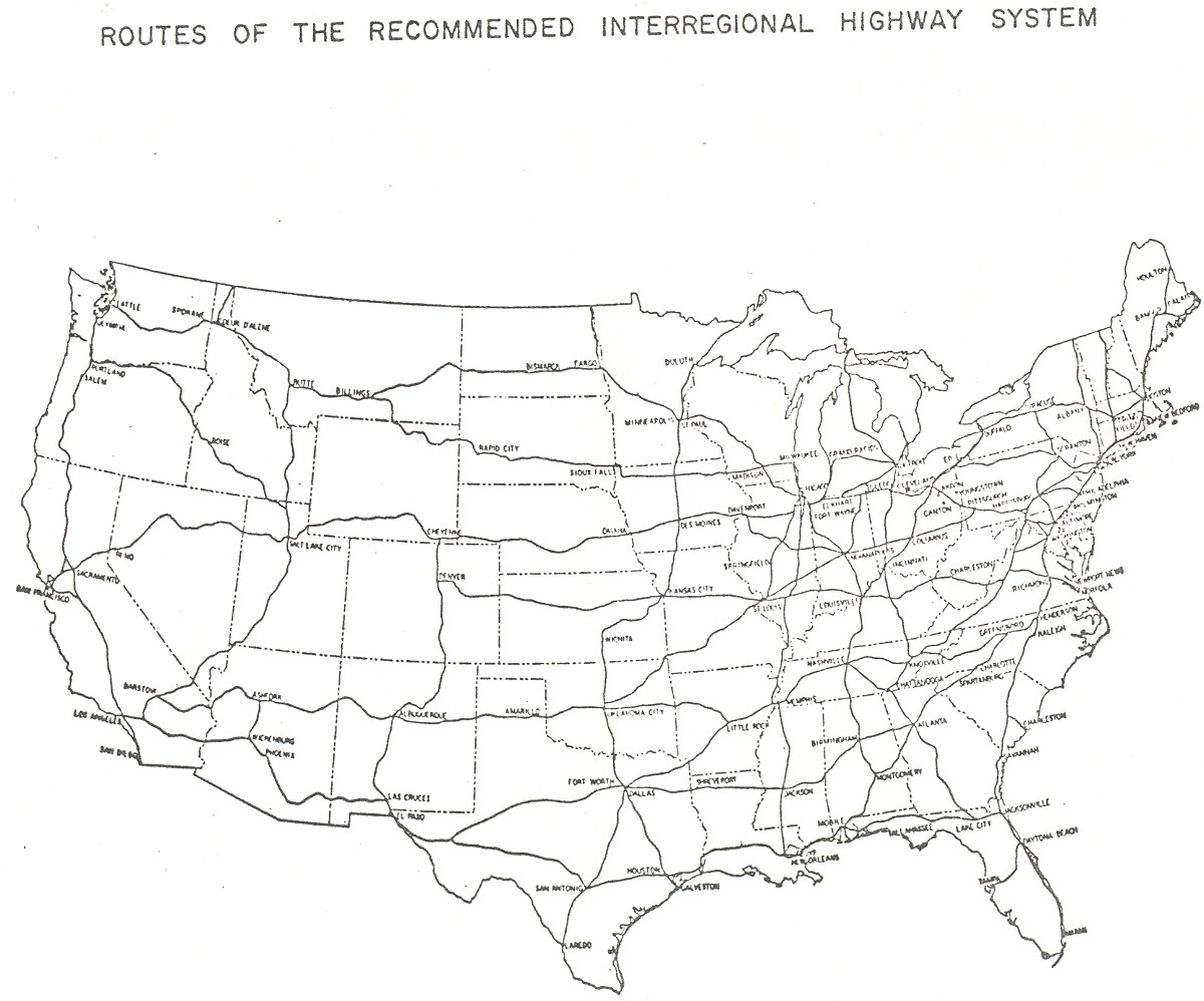
Creation: I-64's origins go back to at least the 1943 Interregional Highway System Proposal. It was not on the 1939 proposed system.
| Adjustments: The following date information comes from the I-64 Wikipedia entry, which references an untitled 2003 WVDOT report I cannot locate on-line. The first segment of I-64 to open was between today's Exit 15 and 20, in 1960. In 1961, per this excellent Gribblenation article on I-64 and I-79 origins, the routng of I-64 from Charleston to the Lewisburg area would no longer follow roughly US 60 but would instead follow the West Virginia Turnpike to the Beckley area, then head east to Lewisburg.
In 1962, I-64 was opened from CR 13 Milton to WV 34. In 1963, I-64 was opened from WV 34 to WV 17 (now WV 817). In 1964, I-64 was opened from Exit 20 to CR 13.
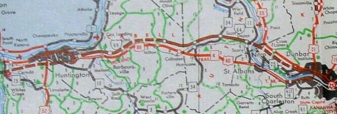
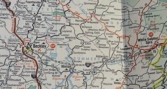
I-64 taking shape between Huntington and Charleston. 1963 Official In 1965, I-64 was opened from the Kentucky state line to US 60 east of Huntington. Also about 1965, per the 1974 EIS of I-64 from Bragg to Beckley, studies were undertaken to determine exactly where I-64 would leave the Turnpike to head east. The initial recommendation was for I-64 to leave the Turnpike at MM 37, well south of Beckley. In 1966, I-64 was opened from WV 17 to WV 25 Institute. Also in 1966, a supplemental study was perfomred on the I-64 path east of the Turnpike, recommending a path around the north of Beckley and intersecting the Turnpike just north of WV 3. It appears the state then concentrated its efforts on determining where I-77 would actually go, as some proposals were not a 100% attach it to the Turnpike. One proposal had I-77 SB using the Turnpike as it is west of Beckley while I-77 NB would run on a newly constructed bypass around the east of Beckley. In 1967, I-64 was opened from Institute to Dunbar. In 1971, I-64 was opened from WV 12 Alta to the Virginia State line. In 1972 (per the 1974 EIS for I-64 Beckley), the EIS for I-77 was completed and thoughts went back to where I-64 should meet it. The EIS studied 7 alternate corridors from the Turnpike to Bragg, which resulted in 5 different potential points of Turnpike Jct over a 12 mile stretch: 1. MM 36 and there would be an interchange with US 19/WV 3 at Shady Spring 2. MM 37 as was recommended in 1965 3. MM 40 with an interchange with US 19/WV 3 in the Glen Morgan area 4. Just north of WV 3 as recommended in 1966 5. At the current US 19 ALT Corridor L interchange - in this scenario, Corridor L would intersect I-64 east of today's US 19/WV 16 and never intersect the Turnpike In 1973, I-64 was opened from US 60 Sam Black Church to WV 12 Alta. In March 1974, the EIS was completed and in April 1974 (AASHO), the route was finally selected (#3 above).
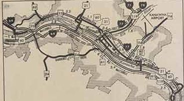
Also in 1974, I-64 was opened from Dunbar to today's Exit 54. In 1975, I-64 was opened from Exit 55 to I-77 in Charleston. In 1976, I-64/77 was opened from the 64-77 split to the north end of the Turnpike.
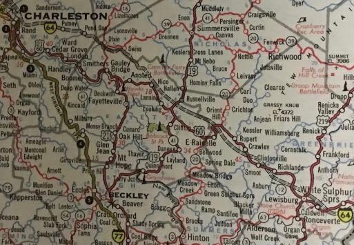
In 1988, the entirety of I-64 from the Turnpike to Sam Black Church was opened. By this time, the Turnpike had been converted to interstate standard and I-64 was signed onto it. Prior to this, I-64 traffic in Charleston heading east was still being directed to follow the mountainous US 60. 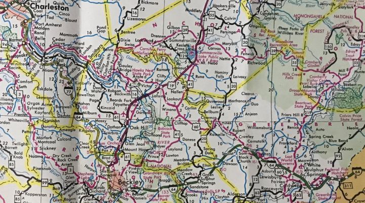
I-64 completed to Beckley and added to I-77/WV Turnpike 1988-89 Official Improvements: Opened as 4 lanes everywhere except Exit 54 US 60 through Charleston to Exit 98 35th St east of the city (about 8 miles). The interstate both directions from the New River bridge has a climbing lane. About 2000, I-64 was 6 laned from Exit 45 WV 25 to Exit 53 Dunbar About 2009, I-64 was 6-laned from Exit 39 WV 34 to the CR 29 underpass west of Exit 44. In 2012, I-64 was 8 laned from the Low Gap Rd underpass east of Exit 53 to Exit 54. In 2021, I-64 was 6-laned from I-77 to US 19 ALT in the Beckley area. New Interchanges: EXIT 45 (Tpk) - Tamarack (1996) EXIT 18 - WV 193 (2001) EXIT 40 - US 35 (2009) Also, Exit 20 was substantially altered in 2001. Comment: Like I-79, many of I-64's exits are signed for primary routes that are nearby instead of the route the exit ramps lead to. I-64 west of Charleston is quite busy and it is being upgraded to be 6+ lanes over to Huntington. Consideration was given to a high bridge over the New River near Sandstone but evidently cost drove the decision to have the interstate descend to the river in both directions. I have hit a deer on I-64 a little east of WV 12. Good times. |
||||||||||