< WV 7 | Home | WV 9 >
|
|
|
| ROUTE LOG |
WV 2: 0 - 0 US 30: 8.5 - 8.5
|
Creation: Created between 1965-70 as a renumbering of part of WV 2, running as it does now. This is the 2nd WV 8.
| Adjustments: None Improvements: Fully paved upon inception; no multilane segments Comment: Not sure why WV 2 was removed from this...
| Previous WV 8's:
1932 ROUTE LOG US 19: 0 - 0 WV 64 NB: 36 - 36 WV 64 SB: 1 - 37 WV 2: 43 - 80 WV 37 WB: 84 - 164 WV 37 EB: 3 - 167 WV 75: 10 - 177 US 60: 5 - 182 |
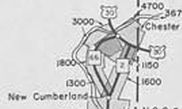
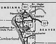
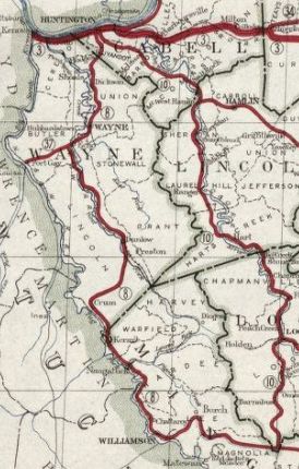
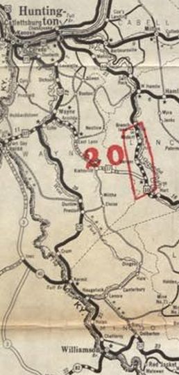
WV 8 #1: Appeared 1922 as new primary routing running from WV 4 (now US 19) Bluefield right at the Virginia line northwest via Welch, Williamson, and Wayne to end at WV 3 (now US 60) Huntington.
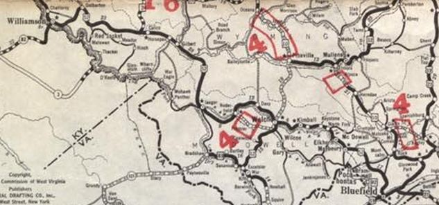
In 1926, the 6th St bridge over the Ohio River at Huntington was opened. It is unclear if WV 8 was placed on it. If so, it was renumbered as part of US 52 in late 1926. Between 1926-28, WV 8 was moved from today's CR 52/1 snd placed on current US 52 from Iager to Roderfield. About 1931, WV 8 was placed on new primary routing between Roderfield and Welch. The route via Davy became an unnumbered primary route. Today it is CR 7 and a little bit of WV 16. In June 1931 (AASHO), WV 8 was renumbered in its entirety as US 52. Today it is approximated by: CR 11 from Bluefield to Bluewell; CR 52/21 Warden Ave; CR 52/6 (no longer connects to)/CR 52/4; US 52; CR 52/38 (no longer connects to)-CR 15-CR 120/1 through Bramwell; more US 52; abandoned routing along Simmons Creek and Booths Hollow to meet CR 52/9 to McDowell County; CR 52/14 to Maybury area; CR 52/12 to Switchback; US 52 to Welch except CR 52/23 near Ennis, CR 52/24 at Upland, CR 52/92 Broadway through North Fork, Main St and Chestnut St in Kimball, CR 52/17 Superior/Maitland; US 52 ALT through Welch; US 52 Welch to Iaeger; US 52 from Iaeger to Gilbert except Backtrack Rd at the Wyoming/McDowell line; CR 52/10 Loop C Rd and CR 52/11 D Loop Rd near Hanover; CR 52/47 Lost Branch Rd (no longer connects to)/CR 52/14 Visitor Center Rd east of Justice; US 52 to the Logan County piece; abandoned routing northwest, then WV 44; CR 252/57 from WV 44 to Taylorsville; US 52 to outskirts of Williamson; Sycamore and Moore Sts in Williamson; partly abandoned loop that used Lt Alex Bucci Rd in Williamson; US 52 to US 119; CR 15 through West Williamson; CR 14 and 14/14 through Goodman; US 52 to WV 152 except CR 252/4 leading to the US 52/119 split, CR 252/21 loop in Kermit, CR 52/79 and CR 52/29 loop at Crum, CR 29/16 and CR 29/9 loop north of Crum; WV 152 to WV 75 except CR 52/49 in the Echo area, CR 37/41 (no longer crosses Twelvepole Ck) and WV 37 into Wayne, Garretts Creek/Norfolk/Cleveland Sts in Wayne; CR 52/39 Camp Rd, CR 52/68 Moore Rd (no longer connects to) CR 52/5 Dickson Dam Rd below Dickson; CR 52/62 Bloss Hill Rd, CR 152/7 Carolyn Dr (no longer connects to), CR 13 Beech Fork Rd below Lavalette; CR 11 and CR 37 McCoy Rd north out of Lavalette which becomes 8th St in Huntington; 8th St all the way to 4th Ave.
|
|||||||||||