ROUTE LOG
US 52, WV 80: 0 - 0
WV 971: 8.7 - 8.7
WV 10 SB: 13.4 - 22.1
WV 10 NB: 0.3 - 22.4
WV 54 SB: 12.1 - 34.5
Raleigh-Wyoming Line: 3.3 - 37.8
WV 305: 7.1 - 44.9
WV 121: 3.1 - 48.0
WV 16 SB, WV 54 END: 0.2 - 48.2
WV 121: 0.4 - 48.6
I-64, I-77 (exit 42), WV 16 NB: 3.7 - 52.3
|
|
Creation: Appeared in 1971 or 1972, running from WV 10 Rock View to WV 54 Maben. This was an upgrade to CR 10/8 to Keyrock, CR 4/2 and CR 4 to Saulsville, and CR 5 to Maben. This is the only WV 97.
Adjustments: Between 1978-80, WV 97 was rerouted west of Saulsville to go to WV 10 further south (replaced CR 4), then extended with WV 10 into Pineville, then west as an upgrade to CR 9 to US 52/WV 80. The old Saulsville to WV 10 Rock View route returned to being CR 10/8 and CR 4/2.
No state official map shows it and even today the county maps don't show it, but by 2000 (per HB Elkins photo) WV 97 was extended north with WV 54 to its end at WV 16, then north with WV 16 to end at I-64/77 in Mabscott.

WV 97 appears
1973 Official
|
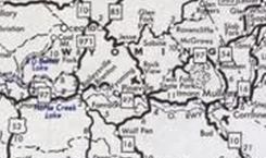
WV 97 extended west to US 52 and rerouted to Pineville directly
1980 Official
|
Improvements: Upon designation, WV 97 was fully paved; WV 97 is multilane on most of its WV 16 overlay.
Comment: WV 97 serves Twin Falls State Park and its extension to I-64/77 may be tied to that.
|