ROUTE LOG
US 50: 0 - 0
US 19 SB: 2.8 - 2.8
US 19 NB: 0.4 - 3.2
WV 20: 2.5 - 5.7
|
|
Creation: Appeared between 1978-80, running from US 19 east to WV 20 Nutter Fort. East of Chestnut St was new construction. This is the only WV 98.
Adjustments: Between 1989-92, WV 98 was extended south with US 19, then west replacing CR 19/11 and CR 50/11 plus a bit of CR 50/39 to US 50.
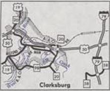
WV 98 from US 19 to WV 20 south of Clarksburg
1980 Official
|

WV 98 extended west to US 50
1992 Official
|
Improvements: Upon designation, WV 98 was fully paved; WV 98 has no multilne segments.
Comment: Not sure why WV 98 and WV 58 aren't the same designation...
|