ROUTE LOG
WV 9: 0 - 0
US 340: 6.1 - 6.1
WV 51: 1.3 - 7.4
WV 9: 5.7 - 13.1
WV 480: 2.5 - 15.6
Berkeley-Jefferson Line: 1.5 - 17.1
WV 9: 2.2 - 19.3
|
|
Creation: Appeared about 1990 as a renumbering of part of WV 9. It originally ran from the new US 340 freeway through Charlestown to the new WV 9 bypass north of Ranson. This is the only WV 115.
Adjustments: About 2007, WV 115 was extended north to WV 480 Kearneysville, mostly over more WV 9 though there was some new alignments to maneuver around interchanges, etc., especially from CR 9/1 Currie Rd to CR 8 Wiltshire Rd. where it is unclear if WV 115 followed War Admiral Rd (shown on Jefferson County map even though it is posted as CR 9/50), duplexes with WV 9 (not posted there either), or was in separate pieces.
By 2019 WV 115 was posted on War Admiral Blvd and does not duplex with WV 9 anywhere.
About 2010, WV 115 was extended north over more WV 9 then west over new construction back to WV 9 in Berkeley County.
In November 2012 (aaroads forum), WV 115 was extended south over WV 9 in the other direction to the new WV 9 alignment at the Virginia State Line.
Improvements: Upon designation, WV 115 was fully paved; WV 115 has no multilane segments
Comment: WV 115 was not posted between US 340 and the Virginia State line until between 2024-26 - there was a reassurance shield leaving US 340 and that was it.
Not sure why it is necessary for WV 115 to exist north of the WV 9 jct past Ranson.
WV 115 is shown but not labeled on official tourism maps but is shown on a different kind of state map on WVDOT's website
|
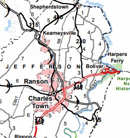
WV 115's full length
2017 Official
|
|