N.C. 36
< 35 | Home | 36-A | 37 >
| N.C. 36 10.6 miles | ||||
| The Road: | Begins at NC 42-50 and ends at US 70/NC 42 Clayton, all within Johnston County | Towns and Attractions: | Johnston Co: Clayton |
History: |
NC 36 appeared in February 2025 replacing NC 42 from NC 50 to I-42, duplexing with I-42, then replacing SR 1560 to end at US 70/NC 42 Clayton. This is the 3rd NC 36.
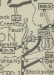
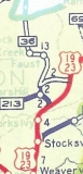
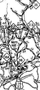
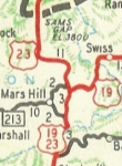
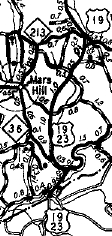
NC 36 #1: Born as part of the late 1934 Great Renumbering. It ran from US 19-23 (current SR 1540) near Forks of Ivy north to Mars Hill then
north to Sams Gap, where it continued into Tennessee as TN 81. In the early days of NC 36, it didn't completely follow today's US 23. Instead, it followed today's US 23 to the settlement of California, then veered off onto SR 1347 Chandler Creek Rd, back across US 23 near Faust, then west along SR 1503, Old US 23, to modern US 23-A which it
followed to Tennessee. This was a replacement for a piece of NC 213 below Mars Hill, the western half of NC 31, and all of NC 311.
|
Comment: | Today's NC 36 was created to eliminate confusion regarding "route 42" for emergency responses in Johnston County, since NC 42 was intersecting the newly designated I-42. However, this now leaves a discontinuous NC 42 (the segment east of NC 36 could have been NC 36 to NC 11 and NC 350 could have been restored to the Ahoskie-Colerain bit. I wonder if there will be signs for NC 42 traffic to follow NC 36? |
Last Update: 7 March 2025
Previous: N.C. 35 |
Next: N.C. 36-A | N.C. 37
Top | NCRoads.com
Home