U.S. 29
< 25 | Home | 29-A | 29A-1 | 29 Bus | 33 >
Photo: US 29 in Grover, showing a rare 2-lane segment of US 29 (Adam Prince)
| U.S. 29 173 miles | |||
| The Road: | Enters from South Carolina at Grover (Cleveland County) and leaves into Virginia near Pelham (Caswell County). Nationally the road runs from US 90-98 Pensacola, FL to MD 99 Ellicott City, MD | Towns and Attractions: | Cleveland Co.: Grover, Kings Mountain
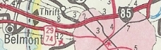
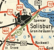
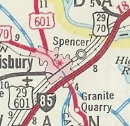
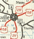
Gaston Co.: Gastonia, Lowell, McAdenville, Cramerton, Belmont Mecklenburg Co.: Charlotte Cabarrus Co.: Charlotte Motor Speedway, W. Concord, Kannapolis Rowan Co.: Landis, China Grove, Salisbury, Spencer Davidson Co.: Lexington, Thomasville Randolph Co.: None Guilford Co.: High Point, Greensboro Rockingham Co.: Reidsville Caswell Co.: None |
History: |
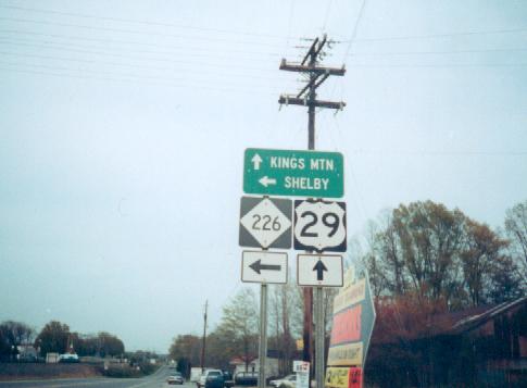
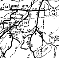
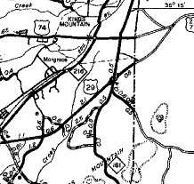
US 29 is an original US Highway. In North Carolina it was attached to NC 205, running only from the S.C. line at Grover to US 74 Kings Mountain.
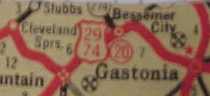
It appears that in 1929, US 29/NC 205 was removed from Margrace Rd below Kings Mountain. In 1932, US 29 was extended with US 74/NC 20 east to Charlotte then replaced US 170 from Charlotte through Concord, Salisbury, Greensboro and Reidville to Virginia. In 1936, US 29-74 replaced NC 7 between Kings Mountain and Gastonia to use modern US 74 Bus and US 29-74. The old route through Bessemer City became US 29A-74A (today this is NC 161 and NC 274).
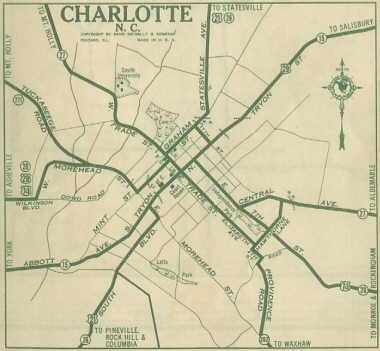
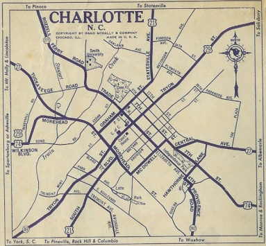
About 1936, US 29's route through Charlotte was altered. Initially, US 29 used Wilkinson Blvd, Morehead St, Mint St, Trade St and Tryon St. Now US 29 used Graham to Trade to Tryon.
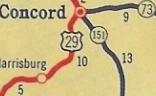
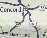
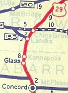
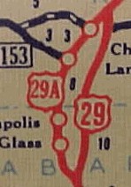
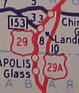
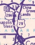
Also about 1936 (bridge date), US 29-70 was removed from S. Salisbury St in Lexington. In 1938, US 29 was placed on a newly constructed bypass of Kannapolis, Landis and China Grove. The old route became US 29-A. Also in 1938, US 29 was rerouted at West Concord from Old Charlotte Rd onto Wilshire Ave east to Union St into Concord.
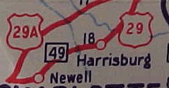
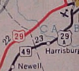
In 1940, US 29 and US 29-A swapped routings and US 29 again went directly through Kannapolis, Landis and China Grove. About 1941, US 29-70 was given its modern routing between the Yadkin River and outside Lexington. The old route used SR 1147 Trading Ford Way/Old Salisbury Rd to I-285; SR 3158 Anna Lewis Dr; Main St into Lexington In 1943 or 1944, US 29 was rerouted to use Dalton to transfer from Graham to Tryon. Between 1939-44, US 29 was removed from Pelham Loop in Pelham. In 1948, US 29 was rerouted away from Newell and Harrisburg to instead use current US 29 via the speedway to West Concord. The old route is Old Concord Rd in Newell, NC 49, Old Charlotte Rd, Wilshire Ave, Union St and Church St.
Also in 1948, US 29 was again put on the bypass of Kannapolis, Landis and china Grove. All of this was a route swap with US 29-A (now decommissioned).
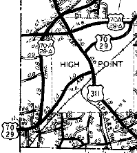
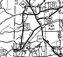
Between 1945-49, US 29 was routed around central High Point using Westchester to Lexington to Greensboro Rd. This was a route swap with US 29A-70A (now just English Rd, Main St and Montlieu out to Greensboro Rd).
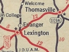
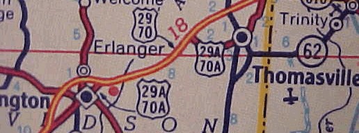
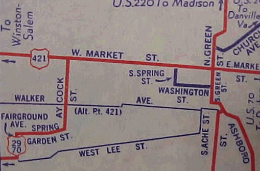
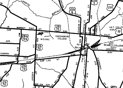
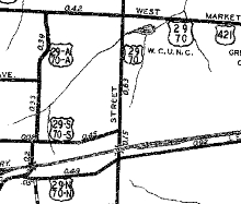
Also between 1945-49, US 29 was placed on brief one-way splits in central Greensboro. NB used Market to Forbes to Summit; SB used Summit to Church to Market. Also in this timeframe, US 29 was removed from Fairground Av and Spring Garden St and instead use Lee directly to Aycock. Fairground Ave became an extended US 29A-70A. About 1949, US 29 was put on its modern routing from Phillips Ave in Greensboro north to the Rockingham County line, leaving behind more Summit Ave and Old Reidsville Rd. Also about 1949, US 29 was given its modern routing between Lexington and Thomasville. This left behind Atlantic St/Greensboro St in eastern Lexington; SR 1844 Greensboro St Ext; SR 2123 Old US Hwy 29; SR 2044 Old Lexington Rd approaching Thomasville. In 1952, US 29 was given bypasses of Lexington and Thomasville, leaving behind US 29-A routes. Today this is SR 1298 Grimes Blvd; SR 3157 Brian Center Dr; Main St/Atlantic St/Greensboro St through Lexington and Lexington Ave/Main St/National Hwy through Thomasville.
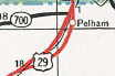
In 1952, US 29 was put on (mostly) its modern route from Ruffin to Virginia. Virginia officials show this better than NC Officials...the old route is a lengthy Old US 29.
Between 1950-53, US 29 was split in southern Greensboro: NB continued to use Lee to Aycock. SB used Aycock, Spring Garden and Fairground down to Lee.
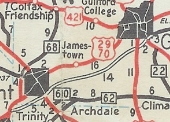
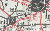
About 1956, US 29 was given its modern routing from Thomasville bypassing High Point, Jamestown, Sedgefield, and downtown Greensboro. The old routing through High Point became US 29-A (now US 70; English Rd, Main St, and Qubein/Montlieu which is no longer continuous through High Point Univ). High Point to Sedgefield became US 29A-70A (now just Greensboro Rd; Main St through Jamestown; Gate City Blvd (except used High Point Rd around I-73 area); Lee St/Aycock/Market/Summit through Greensboro).
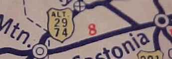
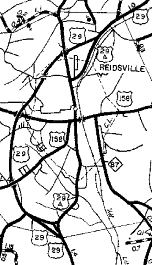
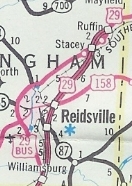
In 1957, US 29 was given a new bypass around the west side of Reidsville, leaving behind US 29-A (now just Scales St and Madison St). About 1957, US 29 was placed on its bypass of Kings Mountain (new construction), leaving behind an extended NC 216 and US 74.
In 1958, US 29 was removed from Charlotte, and was routed over Little Rock Rd, I-85 and today's SR 2772 (exit 42 connection to US 29/NC 49) northeast of Charlotte. The old route remained US 74, US 21 and NC 49. Morehead St became unnumbered. Eventually (1960) this route became US 29 Bus and today is again mainline US 29. In 1960, US 29 was removed from Little Rock Rd and extended further west on newly opened I-85 to NC 273, then used NC 273 back south to US 74, leaving behind more US 29 Bus with US 74. Also in 1960, US 29 was added to I-85 bypassing Salisbury and Spencer, leaving behind US 29 Bus. In June 1963 (NCDOT), US 29 was removed from NC 273 and I-85 and instead returned to its original routing through Charlotte (replacing US 29 Bus).
In 1965, US 29 was returned to running through Salisbury and Spencer, replacing US 29 Bus.
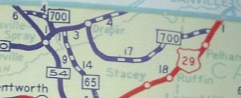
In 1970, a new freeway was built east of Reidville from US 29 south to US 158. It is unclear what if anything was assigned to this freeway (US 29-A?). In October 1973 (NCDOT), US 29 was placed on new freeway to the east of Reidsville which was completed to north of Ruffin. The previous route including the west bypass of Reidsville became US 29 Bus. About 1981, US 29 was placed on freeway north of Ruffin, leaving behind Rail Rd.
In the mid-90s, US 29 was rerouted to avoid what is now Bank of America Stadium. It now leaves Morehead at Mint St, then cuts back over to a rerouted Graham St. In 2014 (bridge date), US 29 was removed from the Wil-Cox Bridge over the Yadkin River. This 1922 bridge is now a trail/park. Adam Prince profiles this historic bridge. |
Comments: |
US 29 in Virginia is known as the Seminole Trail. Oddly, the 1952 Shell Map shows US 29-74 east of Kings Mtn as the Seminole Trail, but this name appears nowhere else on the map.... US 29 is now the step-child for I-85 for most of its existence, but is still nearly all 4-lane. US 29 north of Greensboro is slated to be part of the coming I-785. Improvements to the semi-freeway between I-85 Business and NC 150 have been ongoing for years now to facilitate that designation. A good example of early NC interstate configurations still exist on US 29 in places between Lexington and High Point |
Last Update: 23 March 2025
Previous: U.S. 25 |
Next: U.S. 29-A | U.S. 29A-1 | U.S. 29 Bus | U.S. 33
Top | NCRoads.com
Home