|
|
|
|
ROUTE LOG
US 220: 0 - 0
VA 40 EB: 3.14 - 3.14
VA 40 WB: 0.03 - 3.17
US 220: 2.16 - 5.33
|
|
Creation: US 220 Business for Rocky Mount appeared in Sept 1961 (CTB) when US 220 was placed on new expressway east of town.
Adjustments: None
Improvements: Paved upon inception; 100% multilaned from VA 40 northward
Posted: Fully posted; At least one cutout made it to 1992.
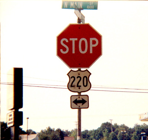
In 2007 there were a number of oval error 220 shields that were replaced not long afterwards with correct shields
Multiplexes: VA 40 (0.03 mi)
Legislative names: Peter Saunders Bridge over Pigg River (3-7-40); W.N. Angle Memorial Bridge over the RR (11-3-55)
Other names: Main St
Scenic Byway: no segments
Comment: Official maps through most of the 1960s incorrectly have this as mainline 220 (with 220 ALT on the bypass).
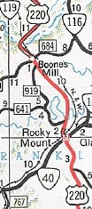
US 220 through Rocky Mount
1956 Official
|
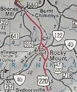
US 220 Bus through Rocky Mount
(US 220 ALT designation in error)
1963 Official
|
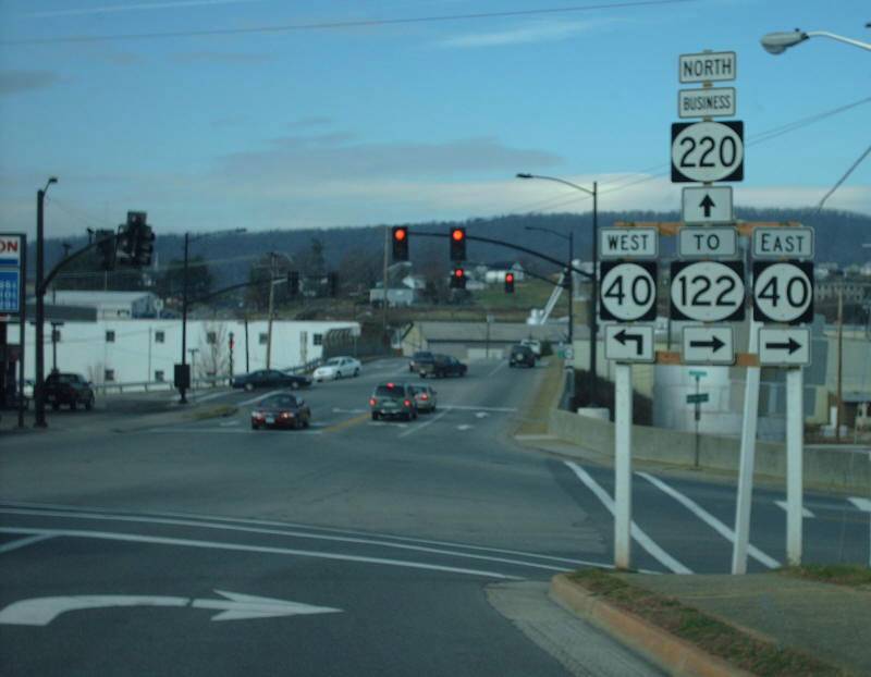
one of several oval 220 business shields
photo by Mapmikey Dec 2007
|
|
|
|
|
|
ROUTE LOG
US 220: 0 - 0
VA 87: 0.83 - 0.83
US 220: 0.85 - 1.68
|
|
Creation: US 220 Business for Ridgeway appeared in April 1963 (CTB) when US 220 was placed on new routing west of town.
Adjustments: None
Improvements: Paved upon inception; no multilane segments
Posted: Fully posted;
Multiplexes: None
Legislative names: none
Other names: Church St (s of VA 87); Main St (n of VA 87)
Scenic Byway: no segments
Comment: Ridgeway is a sleepy little town...
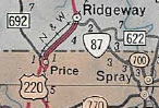
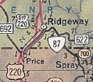
US 220 through Ridgeway
1963 Official
|
US 220 Bus through Ridgeway
1965 Official
|
|
|
|
|
|
ROUTE LOG
US 58, US 220: 0 - 0
US 58 Bus WB: 3.21 - 3.21
Martinsville-Henry Line: 0.72 - 3.93
US 58 Bus EB, VA 57 EB: 0.71 - 4.64
VA 57 WB, VA 457: 1.10 - 5.74
Henry-Martinsville Line: 0.65 - 6.39
VA 174: 3.01 - 9.40
US 220, VA 57: 1.30 - 10.70
|
|
Creation: US 220 Business for Martinsville appeared in July 1976 (CTB) when US 220 was placed on new expressway west of town. The south end of US 220 Business initially was at US 58 just south of the Smith River.
Adjustments: In Nov 1977 (CTB), US 220 Business was extended south its current end when the rest of the US 220 bypass freeway was completed south of US 58.
Improvements: Paved upon inception; 100% multilaned from inception
Posted: Fully posted;
Multiplexes: US 58 Bus (1.43 mi)
VA 57 (1.10 mi)
Legislative names: none
Other names: Greensboro Rd (s of 58 Bus); Memorial Blvd; Virginia Ave (n of Martinsville CL)
Scenic Byway: no segments
Comment: The Martinsville Speedway is directly on US 220 Business.

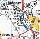
US 220 through Martinsville
1958 Henry County
|
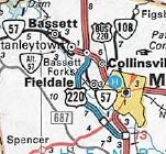
US 220 Business through Martinsville
1977 Official
|
US 220 Business extended south
1978 Official
|
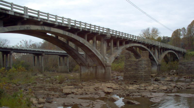
Beautiful Smith River Bridge on US 58-220 Business
photo by Mapmikey Oct 2006
|
|
|
|
|
|
ROUTE LOG
US 220, VA 419: 0 - 0
US 220: 2.34 - 2.34
US 221 SB: 1.20 - 3.54
VA 116 SB: 0.30 - 3.84
US 11 SB: 0.28 - 4.12
I-581 (exit 8), US 11 NB, US 220, US 221 NB, VA 116 NB: 0.30 - 4.42
|
|
Creation: US 220 Business for Roanoke looks to have been created about 1974 when the freeway carrying I-581/US 220 was extended south to Franklin Rd. Both the 1975 VDOT City Atlas and state officials up through 1994 show no primary route on Franklin Rd south of VA 116, a 1975 picture confirms 220 Business was signed downtown.
Adjustments:In Dec 1980 (CTB) US 220 Business was extended south when US 220 was placed on new expressway from Franklin St south to VA 419.
Improvements: Paved upon inception; Multilaned upon inception everywhere except between McClannahan St and US 221.
Posted: Fully posted, including mini white border shields in most places; A number of cutouts made it to the early 1990s.
Multiplexes: US 221 (0.30 mi)
US 221, VA 116 (0.28 mi)
US 11, US 221, VA 116 (0.30 mi)
Legislative names: none
Other names: Franklin Rd; Williamson Rd
Scenic Byway: no segments
Comment: US 220 Business within downtown is not recognized in the traffic logs.
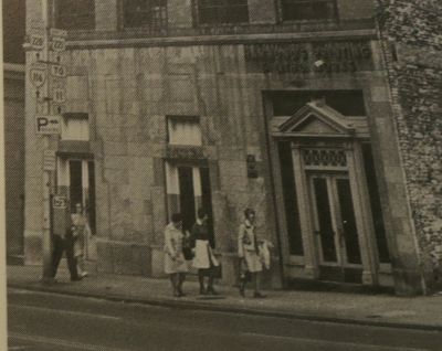
US 220 Bus shown posted in 1975
1975 photo by Carolyn Hale Bruce
from a pictoral history of Roanoke book
|
US 220 Bus shown south of downtown only
1986 Official
|
US 220 Bus extended to downtown
1994 Official
|
|
|
|
|
|
|
|
ROUTE LOG
US 220: 0 - 0
US 60 Bus EB: 1.50 - 1.50
VA 188: 0.32 - 1.82
I-64 (exit 24), US 60, US 220, US 220 Bus BEGIN, VA 384: 1.31 - 3.13
|
|
Creation: Appeared Dec 1987 (AASHTO) when US 220 was placed on I-64 around the north side of Clifton
Forge.
Adjustments: It appears US 60-220 was
put on one-way splits in Clifton Forge in 1972.
In summer 2011, US 60-220 Bus was returned to two-way traffic through downtown. Ridgeway St became US 60 Business TRUCK.
Improvements: Paved upon inception; Multilane from Clifton Forge CL west, likely since inception.
Posted: Fully posted although BUSINESS banners are missing in many locations; several cutouts remain as of Aug 2021 (GMSV).
Multiplexes: US 60 Bus (1.63 mi)
Legislative names: Robert F. Craft Memorial Bridge, Jackson River (since 10/26/67)
Other names: Ridgeway St; Main St; A St; Verge St
Scenic Byway: no segments
Comment: Clifton Forge reverted from an independent city back to incorporated town in the early 2000s.
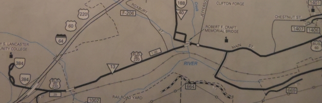
US 220 Business through Clifton Forge
1995 Alleghany County
|
Previous: US 219 |
Next: US 221
US 220 | US 220 ALT | US 220-Y
Top | Virginia Hwy Index
Home
Page last modified
5 March 2022
| | | |