US 23 Business
< US 21 | Home | US 23E >
US 23 | US 23 ALT
US 23 view
Photo: US 23 Business leaving Norton (photo by Mapmikey 5/24/08)

From:  Hamiltontown (Wise County)
To:  near Wise C.H. (Wise County)
Total Length:  2.75 miles  
ROUTE LOG
US 23: 0 - 0
US 23: 2.75 - 2.75
Creation: Appeared Oct 1966 (CTB) when US 23 was placed on a new bypass around the west side of Wise C.H. This is the 1st US 23 Business.
Adjustments: In Sept 1970 (CTB), US 23 Business south was extended from SR 757 to the current US 23 routing, replacing a bit of what had been the US 23 Bypass.
Improvements:  Paved upon inception; Multilane from Cherry St to SR 640.
Posted:  Fully posted; A cutout was still present NB SR 640 in summer 2009 (gone by 2016); square 23 shields were also present in summer 2009 at SR 640 (gone by 2016); white I-23 shield SB after SR 757 from 2000 has been replaced.
Multiplexes:  None
Legislative names:  Trail of the Lonesome Pine (since 3/24/30)
Other names:  Norton Rd, Main St
Scenic Byway:  Entire route (since 3/8/93)
Comment: US 23 Business did not appear on Officials until 1969.
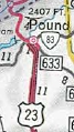
1969 Official
US 23 Bus in Wise
1969 Official


From: Gate City (Scott County)
To:  Gate City (Scott County)
Total Length: 2.65 miles  
ROUTE LOG
US 23, US 58, US 421: 0 - 0
VA 71: 1.95 - 1.95
US 23, US 58, US 421: 0.70 - 2.65
Creation: US 23 Business for Gate City appeared in Oct 1966 (CTB) when US 23-58-421 was placed on new expressway south of town. This is the 2nd US 23 Business.
Adjustments: None
Improvements:  Paved upon inception; Multilane from about VA 71 east to Bypass
Posted:  Fully posted; Cutouts removed in late 90s.
Multiplexes:  US 23 Bus, US 421 Bus (entire route)
Legislative names:  None
Other names:  Daniel Boone Rd, W. Jackson St
Scenic Byway:  no segments
Comment: The Gate City bypass does not appear on officials until 1969.
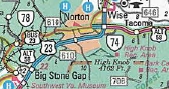
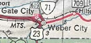
1969 Official
1969 Official

From:  near Pound (Wise County)
To:  Pound (Wise County)
Total Length:  3.08 miles  
ROUTE LOG
US 23: 0 - 0
VA 83: 1.80 - 1.80
US 23: 1.28 - 3.08
Creation: Appeared Aug 1968 (CTB) when US 23 was placed on a new bypass around the west side of Pound. This is the 3rd US 23 Business.
Adjustments: None
Improvements:  Paved upon inception; no multilane segments
Posted:  Fully posted;
Multiplexes:  None
Legislative names:  Trail of the Lonesome Pine (since 3/24/30)
Other names:  Indian Creek Rd, Main St
Scenic Byway:  Entire route (since 3/8/93)
Comment: None
1969 Official
US 23 Bus in Pound
1969 Official


From:  near Oreton (Wise County)
To:  Esserville (Wise County)
Total Length:  3.08 miles  
ROUTE LOG
US 23, US 58 ALT EB: 0 - 0
US 58 ALT WB: 1.52 - 1.52
VA 68: 2.24 - 3.76
VA 78: 0.50 - 4.26
Norton-Wise Line: 9.44 - 13.70
VA 74: 1.82 - 15.52
VA 283: 0.26 - 15.78
Wise-Norton Line: 1.50 - 17.28
US 23: 0.40 - 17.68
Creation: Appeared in Oct 1983 (AASHTO) when US 23 was placed on a new bypass around the east side of Esserville. it's south end was at today's VA 283. This is the 4th US 23 Business.
Adjustments: In Aug 1991 (CTB), US 23 Business was extended through Norton, Appalachia, and Big Stone Gap as the new 23 bypass was completed.
Improvements:  Paved upon inception; multilane within Norton
Posted:  Fully posted; a cutout remains in Big Stone Gap as of 2015; several cutouts remain in Norton.
Multiplexes:  US 58 ALT (1.52 mi)
Legislative names:  Trail of the Lonesome Pine (since 3/24/30)
Other names:  Park Ave (Norton); Kent Junction Rd; Main St (Appalachia); Roaring Branch Rd; 5th St/Gilley Ave (Big Stone Gap)
Scenic Byway:  Entire route (since 3/8/93)
Comment: US 23 Business is a scenic ride through these mountain communities.
1989 Official
US 23 bypasses Esserville
1989 Official
1994 Official
US 23 bypasses everybody
1994 Official

Previous: US 21  |  Next: US 23E
US 23 | US 23 ALT
Top  |  Virginia Hwy Index Home

Page last modified 3 February 2022