ROUTE LOG
VA 3: 0 - 0
END VA 347: 2.98 - 2.98
|
|
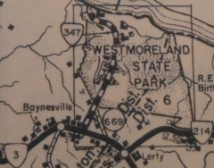
Creation: VA 347 was created in July 1940 (CTB) when Park route R-1 in Westmoreland State Park (opened in 1936) were taken into the primary system, a total of 2.48 miles. This is the only VA 347.
Adjustments: In Aug 1947 (CTB), the road leading to the bath house was added to VA 347.
Improvements: paved since 1951; There are divided sections but only 1 travel lane in each direction.
Posted: Fully posted in shields at VA 3. No internal postings.
Multiplexes: None
Legislative names: None
Other names: State Park Rd
Scenic Byway: Entire route, since 8/15/02
Comment: VA 347 appears on officials since July 1940.
Although there is an unpaved SR 669 Old Park Rd that crosses VA 347, this was never part of VA 347 even in its pre-paved days.
VA 347
1940 Official
|
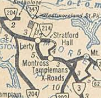
VA 347 initial routing not using SR 669
1946 Westmoreland County |
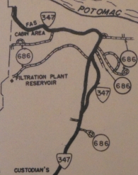
VA 347 paved and split
1951 Westmoreland County |
VA 347's descent to the Potomac River is as twisty as a mountain descent!
Some roads within the park are SR 686.
|
