< VA 400 | Home | VA 402 >
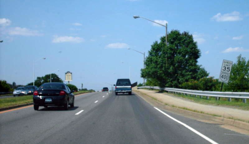
Photo: Transitioning from SR 613 to VA 401 (photo by Mapmikey, July 2008)
| US 401 | |||
| ||||||||||
| ROUTE LOG Alexandria-Fairfax Line: 0 - 0 VA 236: 1.05 - 1.05 VA 420: 1.79 - 2.84 |
Creation: Appeared in Nov 1980 (CTB) as an upgrade to what was
once SR 613. Ran from the SCL of Alexandria north of I-95/495 along Van
Dorn St to VA 236. This is the 3rd VA 401.
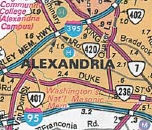
Adjustments: In June 1984 (CTB), VA 401 was extended north along Van Dorn St, then over Kenmore Ave to end at VA 420 Seminary Rd. In April 2013, VDOT recommended that VA 401 be extended south nearly 3 miles to SR 611 Telegraph Rd. This didn't go anywhere because Fairfax County didn't support the extension. Improvements: Paved and multilaned upon inception Posted: Fully posted south of VA 236 (but not from VA 236). As of 2023 modern white border signs are still up. It appears there were briefly VA 401 shields on some I-95/495 signs when the express lanes through Alexandria were completed...the SR 613 shields are patches... Multiplexes: None Legislative names: None Other names: Van Dorn St, Kenmore Ave Scenic Byway: None Comment: VA 401 is a highly-used thoroughfare in Alexandria, serving as access to the Capital Beltway and also Landmark Mall. VA 401 is not mentioned at all from the Beltway even though it is very close by.
| |||||||||
| Previous VA 401's:
1932 ROUTE LOG NC STATE LINE: 0 - 0 US 58 WB, VA 12 WB: 19 - 19 US 58 EB, VA 12 EB: 1 - 20 US 1 SB, VA 31 SB: 6.5 - 26.5 US 1 NB, VA 31 NB: 0.5 - 27 VA 437: 2 - 29 VA 423: 4 - 33 VA 433: 5 - 38 VA 48: 4 - 42 |
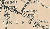
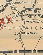
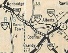
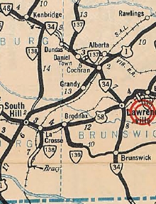
VA 401 #1: Appeared in Aug 1928 as an upgrade to CRs 12, 17, 7
and 1. It initially ran from the North Carolina line south of
Valentines up to Lawrenceville, then northwest 1.25 miles. A second
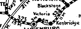
piece of VA 401 replaced VA 323 from
VA 44 (now VA 49) Victoria southeast to Kenbridge, then continued as an
upgrade to CR 7 southeast 8.8 miles to the Dundas area.
In Aug 1929 (CTB), the southern piece of VA 401 was extended north 2 miles. In 1930, VA 401 from Victoria to Kenbridge was renumbered as an extended VA 48 (today it is VA 40).
In June 1930 (CTB), the southern piece of VA 401 was extended to and along a brief duplex north with US 1, then northwest 10 miles to the Lunenburg County line, connecting the two pieces. It appears in 1932 that VA 401 moved from SR 713 to SR 715 to head north into Lawrenceville. In July 1933, VA 401 was renumbered as VA 34.
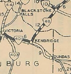
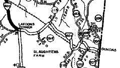
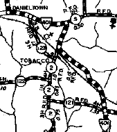
Today, the route is VA 46 from the NC Line north, using SR 768 loop near the state line and the SR 767 and SR 766 loops above Brunswick. VA 401 then cut east on SR 715 over the Gholson Bridge over the Meherrin River, back around to VA 46. The route followed VA 46 to Cochran, then US 1 north, then SR 758 which is cutoff by I-85. The route picks up VA 46 again. Just north of SR 652, VA 401 crossed the RR and stayed north of it (no longer public road) all the way to SR 644, then went north to SR 643 then west to SR 729 over to Danieltown. VA 401 then crossed VA 46 to stay on SR 729 which no longer connects to VA 137. VA 401 picked up VA 137 through Dundas, then used SR 616 south across the RR, then northwest on what is not a public road back to VA 137. VA 401 then followed VA 137 to VA 40 in Kenbridge.
VA 401 #2: First mentioned in CTB Minutes in September 1957, as the route assigned to the Emporia Bypass. VA 401 was also in the October 1957 minutes describing a new route from US 1 Triangle to VA 350 Woodbridge. VA 401 was the assigned state route number to I-95. It was last mentioned in the CTB minutes in February 1987. VA 401 was not likely ever signed as such. |
|||||||||

Previous: VA 400 |
Next: VA 402
Top | Virginia Hwy Index
Home
Page last modified 10 February 2025