< VA 418 | Home | VA 420 >

Photo: VA 311 northbound at VA 419, before the roundabout was built here (photo by Mapmikey, 1/27/07)
| |||||||
| ROUTE LOG US 220, US 220 Bus: 0 - 0 Roanoke-Roanoke City Line: 0.07 - 0.07 US 221: 2.21 - 2.28 Salem-Roanoke Line: 3.16 - 5.44 US 11: 0.69 - 6.13 US 11 ALT SB, US 460 ALT WB: 1.47 - 7.60 US 11 ALT NB, US 460, US 460 ALT END: 0.53 - 8.13 Roanoke-Salem Line: 0.88 - 9.01 I-81 (exit 141): 0.96 - 9.97 VA 311: 0.57 - 10.54 |
Creation: Appeared in Sept 1964 (CTB) as a renumbering of VA 119 running from US 220 Cave Spring to US 11 ALT Salem. This is the 3rd VA 419.
Adjustments: In Feb 1966 (CTB), VA 419 was largely rebuilt from US 220 to US 11 onto the current routing. This left behind SR 904 Starkey Rd; SR 613 Merriman Rd; SR 897 Crystal Creek Dr; US 221; Old Cave Spring Rd; all the McIvity Rd segments between US 221 and US 11 near the Roanoke River. Officials didn't start showing this change until 1971. In Dec 1968 (CTB), VA 419 was extended north as new construction to I-81, then replaced VA 116 from I-81 to VA 311.
Improvements: Paved upon inception VA 419 was first multilaned on its 1968 extension to I-81 VA 419 was multilaned from US 220 to US 221 in 1972 VA 419 was multilaned from US 221 to US 11 in 1975. VA 419 was multilaned from US 11 to US 11-460 ALT in 1977. VA 419 is still 2-lane north of I-81. Posting: Fully posted; Multiplexes: None Legislative names: Jubal Anderson Early Highway, from SR 780 to VA 311 (10-15-53 designation predates VA 419) Other names: Electric Rd Scenic Byway: None Comment: VA 419 provides a major thoroughfare from I-81 to the Cave Spring and South Roanoke areas. VA 419 also provides easy access from I-81 to VA 311 NB and was once the only way to get to VA 311 from the interstate. | ||||||
| Previous VA 419's:
1932 ROUTE LOG VA 19: 0 - 0 VA 418: 24 - 24 1964 ROUTE LOG US 58: 0 - 0 NC STATE LINE: 3.1 - 3.1 |
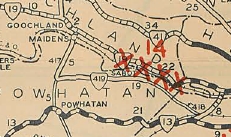
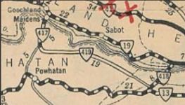
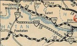
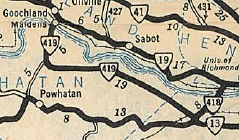
VA 419 #1: Appeared in August 1928 as an upgrade to CRs 17 and 1 from VA 417 (now US 522) Jefferson east 10.17 miles
In Aug 1929 (CTB), VA 419 was extended east 1.5 miles. In June 1930 (CTB), VA 419 was extended east to the Chesterfield County Line.
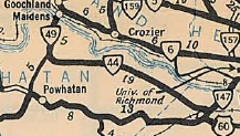
In Dec 1930 (CTB), VA 419 was extended east to VA 418 (now VA 147). In 1932, VA 419 was extended over VA 417 from Jefferson to VA 19 (now VA 6) Goochland C.H. In July 1933, VA 419 was renumbered as part of VA 49 from Jefferson to Goochland (now US 522, SR 664 and SR 710/717) and all of VA 44 from Jefferson to VA 147 (now SR 711 except VA 419 used SR 641 Fine Creek Loop and east of VA 288 used Twin Team Ln, Powderham Ln, and Grey Oaks Ln).
VA 419 #2: Appeared in June 1964 (CTB), as an upgrade to SR 694 in Halifax County, running from US 58 south to the North Carolina Line. The designation was meant to be temporry pending action by the Cities of Salem and Roanoke regarding longtime-VA 119 there. In Sept 1964 (CTB), VA 419 was renumbered as VA 119 in a route swap. No map I have seen shows VA 419 here but the Sept 1964 CTB minutes clearly indicate 419 was the number in Halifax County. |
||||||
Previous: VA 418 |
Next: VA 420
Top | Virginia Hwy Index
Home
Page last modified 16 February 2025